LovingGulfLows
Member
- Joined
- Jan 5, 2017
- Messages
- 1,499
- Reaction score
- 4,100
Well RGEM actually trended better for me. Now I'll actually see some token flakes at the end. #winning
Assuming this trend continues on the 12z GFS, I would anticipate that BMX will downgrade the warning to an advisory.
All aboard the train. Destination is Bust City.
I don't think so. The models trend at the time were pretty good for what they issued. I am sure after all the 12z and 18z runs are completed today they will reevaluate the situation.Is it technically a bust if BMX downgrades to an advisory ahead of time?


He's always the snow buster lover. GFS coming back some.Just talked to Rob Smith. Too warm.


You don't want to know. He's a met. that loves to bust hopes of snow lovers. He loves it.Who is rob smith?
Sent from my iPhone using Tapatalk
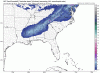
Looks to be slowing down, hence more moisture
lol.. I should have not said anything. You don't want to know. I'll be quite now.Who is rob smith?
Sent from my iPhone using Tapatalk

Who is rob smith?
Sent from my iPhone using Tapatalk


Yea. Would think they would wait till after 12z and 18z completed since it not affecting them til later on in the day tomorrow.I'm surprised Atlanta Public School decided to close this early.
I'm surprised Atlanta Public School decided to close this early.
Storm looks to hit at the worst time. Too early for early dismissal options
Sent from my iPhone using Tapatalk
Should have another frame left12z cmc is a nod towards the NAM. Of course it’s looked like hell for the past 4 days
Sent from my iPhone using Tapatalk
They are going to avoid Snow Jam III whatever the cost.Also, Kemp closed all State offices, so I'm sure that persuaded them a bit.

I can say they have about 0.3 inches here now. But that's just FFC. I can't figure out Morristown's call map and why it's so high.Something I've noticed is that the models seem to be trending worse for SE TN/NW GA but the NWS and local mets are remaining bullish on accumulation totals. What are they seeing that most of the models aren't showing?