NAM looks slower this run.
-
Hello, please take a minute to check out our awesome content, contributed by the wonderful members of our community. We hope you'll add your own thoughts and opinions by making a free account!
You are using an out of date browser. It may not display this or other websites correctly.
You should upgrade or use an alternative browser.
You should upgrade or use an alternative browser.
Wintry January 29th-30th ARCC Slam Dunk Winter Weather Threat
- Thread starter ForsythSnow
- Start date
accu35
Member
Might be a good nam run, I hope
Snowflowxxl
Member
This run already looking promising
NAM looks slower this run.
Yeah, it's a little slower (and stronger) looking at hr 60 compared to 12z.


RollTide18
Member
This run already looking promising
Very good, looking like it’s trying to wind up

Snowflowxxl
Member
This is ideal
RollTide18
Member

Yeah, it's definitely slowing down, at 12z Tuesday the snow is just starting to enter NW AL, other models had it coming into NW GA or ATL metro by then.

LovingGulfLows
Member
- Joined
- Jan 5, 2017
- Messages
- 1,499
- Reaction score
- 4,100
ATL goes from heavy rain to light snow. Imagine if it was cold enough.

accu35
Member

Well that was an interesting run. lol

NoSnowATL
Member
LovingGulfLows
Member
- Joined
- Jan 5, 2017
- Messages
- 1,499
- Reaction score
- 4,100
It goes bonkers with the precip rates over GA, but it's not cold enough.
Stormlover
Member

Blue_Ridge_Escarpment
Member
Wow even N.C. east of the mtns is looking good now. What a winter here!!
Snowflowxxl
Member
I'd imagine we are close to a even bigger deal.
Stormlover
Member
say what?It goes bonkers with the precip rates over GA, but it's not cold enough.
NBAcentel
Member
With a low like that based off what the NAM is showing there would be a deform band east of the apps
Snowflowxxl
Member
Where do I cash out? We hug lol!
ATL got NAM'd!
ATLwxfan
Member
Dang. Hope it’s cold
Sent from my iPhone using Tapatalk
NorthGaWinter4
Member
We just got NAMed
RollTide18
Member
ATL got NAM'd!
I-85 from MGM to ATL got NAM’d at that, cant wait til 0z.
??? Why is COD's version of this map more aggressive with the kuchera snowfall totals than the Pivotal version?
NBAcentel
Member
North GA/NC got NAM’ed lol
NoSnowATL
Member
Haha this should be in banter since it’s crazy. I go from .03 to 7in. Ok then.
Sent from my iPhone using Tapatalk
JLL1973
Member
Nam looks good for north ms. I don't care what the other models show. I'm riding the nam to glory
mjscott30
Member
I know, right? I'm afraid to get too excited and jinx it.I-85 from MGM to ATL got NAM’d at that, cant wait til 0z.
I know people are desperate and trying to cling to whatever model shows them getting the most snow, but keep in mind it's still too early to take the NAM too seriously.
olhausen
Member
This looks great but doesn’t the nam always overdue precipitation totals? Believe me I hope it’s on to something as it’s the best run for I’ve seen since yesterday morning.
Model trends seem to be highlighting central and northern MS for the higher accumulation potential (outside of the Apps). I'm glad I made the decision to stay in Clinton, MS Monday night and Tuesday. Depending on road conditions, I might have to wait until Wednesday to drive back home though.
NBAcentel
Member
If I’m not mistaken the upgraded NAM has a drier bias now, was to dry with the ZR that last ice storm in nc but trended up as it got closer
GeorgiaGirl
Member
This looks great but but doesn’t the nam always overdue precipitation totals? Believe me I hope it’s on to something as it’s the best run for I’ve seen since yesterday morning.
Actually they corrected it and maybe went overboard according to someone here last month. The point though is I think the changes to where it's looked more like the Euro happen in it's reasonable time.
Point of this is still the same though, if no low develops, it'll probably just be light precip.
weatherguy
Member
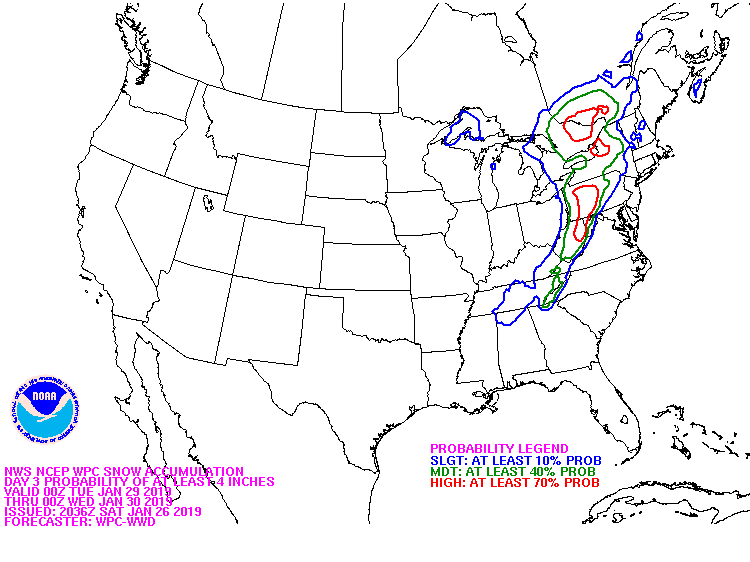
New WPC map has brought the 10% or greater probability of 4"+ of snow down into AL :
GeorgiaGirl
Member
Just realized I posted the wrong maps. :fp: Here's the actual 10:1 and Kuchera.


This is wild, sheesh.
This is wild, sheesh.
olhausen
Member
Looking at it now it seems to keep the precipitation around longer then the 12z gfs.Actually they corrected it and maybe went overboard according to someone here last month. The point though is I think the changes to where it's looked more like the Euro happen in it's reasonable time.
Point of this is still the same though, if no low develops, it'll probably just be light precip.
This map is laughable at best. 7" for Atlanta and 45 miles west in Carrollton not a flake. Yeah I'm sure that will happen.Just realized I posted the wrong maps. :fp: Here's the actual 10:1 and Kuchera.
View attachment 13595
View attachment 13596
This is wild, sheesh.
Pardon my ignorance (and going off-topic), but how accurate are these Kuchera maps compared to the standard 10:1 ratio maps and do they include sleet accumulations?