Storm5
Member
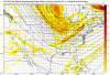
Through 00z Wednesday . No doubt the ugliest run yet . It’s like watching a slow death
18z vs 00z


Sent from my iPhone using Tapatalk
18z vs 00z


Sent from my iPhone using Tapatalk
it's about it melting and freezing..that's the worst road..get's like a skating rinkIf an inch of snow causes you to run off the road, i would hate to see what 6 inches or more would do !
Can you explain how it's caving to euro, I'm just asking not being sarcastic LoL. I'm just curious that's all
FV3 just caused me to run off the road! Liking the trends for central Alabama!
Through 00z Wednesday . No doubt the ugliest run yet . It’s like watching a slow death
18z vs 00z
Sent from my iPhone using Tapatalk

That looks worse than 12z, much lighter it appears.Euro is going to stay the course I believe. View attachment 13426
That looks worse than 12z, much lighter it appears.


Does I t looks like it tried to develop a surface low to you ??The interesting part will be does it keep the surface wave.


Looks to me king has held serve. So now I wonder who we believe?? The king or gfs???Solid 2-4 inch event according to Euro. All hail the KING
View attachment 13436View attachment 13437
 old run 12z
Does I t looks like it tried to develop a surface low to you ??
Ironic how these kuchera maps are better on snowfall accumulations here than the 10:1 ratio maps. I thought it would be the opposite.
Memphis get shafted in qpf on this run .. about the same in the rest of the areas if not a little better
New runView attachment 13439old run 12z
View attachment 13440