RollTide18
Member
This actually is better for central and south central Alabama compared to 18z.
The GFS is in the process of caving to the Euro so don't really worry about what the surface looks like.
cmc sucks too....if euro does..then I'll be worried but the nam looks great...time to get into some sref plumes
Can you explain how it's caving to euro, I'm just asking not being sarcastic LoL. I'm just curious that's allThe GFS is in the process of caving to the Euro so don't really worry about what the surface looks like.

He means that it is thinking about developing that lowCan you explain how it's caving to euro, I'm just asking not being sarcastic LoL. I'm just curious that's all


Hate to say it big decrease I think in the gefs.
Funny how 12 hours makes a difference. ??????

Believe it or, this has trended better for us south Bama folksThat's an understatement. Ouch.


I just don’t understand. WTH!!
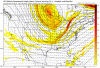
New run 0z gefs
View attachment 13408
12 hours earlier. 12z gefs. View attachment 13409
You better take it in a hurry. Tomorrow night might look like this.I’ll take it all day . Will be interesting to see if the euro trends a little south as well
Sent from my iPhone using Tapatalk

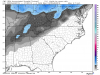
Ok this is 12z hour 108. It’s still looks way better then tonight’s.Your going way to far out in the run
Sent from my iPhone using Tapatalk

I just don’t understand. WTH!!
New run 0z gefs
View attachment 13408
12 hours earlier. 12z gefs. View attachment 13409
Also 108 hour on new run.Your going way to far out in the run
Sent from my iPhone using Tapatalk

Ok this is 12z hour 108. It’s still looks way better then tonight’s.View attachment 13413


I mean let’s be honest the models are an utter joke at this point. We know this is always possible but it never gets easier when you are 4 or less days away and it goes away. Maybe trends will turn our way but it’s doubtful. Here’s to the euro at least hopefully looking better then the gfs!Well I just did what I said I wouldn’t do. I was living by the models. And now I died by the models.
Time to reset for Euro. ???
If an inch of snow causes you to run off the road, i would hate to see what 6 inches or more would do !FV3 just caused me to run off the road! Liking the trends for central Alabama!
If an inch of snow causes you to run off the road, i would hate to see what 6 inches or more would do !