• Hello, please take a minute to check out our awesome content, contributed by the wonderful members of our community. We hope you'll add your own thoughts and opinions by making a free account!

Wintry January 29th-30th ARCC Slam Dunk Winter Weather Threat

Here's the precip totals from the 18z gfs. If this verifies, I'll take my chances.
View attachment 13869
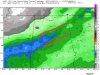
Clearly an uptick, you might be in a good spot...
7ddced735bd285615f8540cbad9ea5bd.gif


Sent from my SM-G950U using Tapatalk
 
NWS Jackson issued a Winter Storm Watch

URGENT - WINTER WEATHER MESSAGE National Weather Service Jackson MS 351 PM CST Sun Jan 27 2019 ...WINTER STORM WATCH IN EFFECT FOR MUCH OF THE ARKLAMISS REGION .A strong cold front will combine with a weather disturbance to bring wintry precipitation to the ArkLaMiss region Monday night into Tuesday morning. There is increasing confidence that significant snowfall will occur as temperatures fall rapidly behind the cold front changing rain to snow. With temperatures falling below freezing, icing of roads, and especially bridges and overpasses, will become a concern as we near the morning commute. In addition, strong wind will combine with the cold temperatures to make for very cold wind chill readings. Stay tuned for updates on this developing winter weather situation. LAZ007>009-015-016-023-025-MSZ030>033-035>059-280600- /O.NEW.KJAN.WS.A.0001.190129T0600Z-190129T1800Z/ Morehouse-West Carroll-East Carroll-Richland-Madison LA- Franklin LA-Tensas-Clay-Lowndes-Choctaw-Oktibbeha-Humphreys- Holmes-Attala-Winston-Noxubee-Issaquena-Sharkey-Yazoo-Madison MS- Leake-Neshoba-Kemper-Warren-Hinds-Rankin-Scott-Newton-Lauderdale- Claiborne-Copiah-Simpson-Smith-Jasper-Clarke-Jefferson- Including the cities of Bastrop, Oak Grove, Epps, Lake Providence, Rayville, Delhi, Tallulah, Winnsboro, Newellton, St. Joseph, Waterproof, West Point, Columbus, Ackerman, Weir, Starkville, Belzoni, Isola, Durant, Tchula, Lexington, Pickens, Goodman, Kosciusko, Louisville, Macon, Brooksville, Mayersville, Rolling Fork, Anguilla, Yazoo City, Ridgeland, Madison, Canton, Carthage, Philadelphia, Pearl River, De Kalb, Scooba, Vicksburg, Jackson, Pearl, Brandon, Richland, Forest, Morton, Newton, Union, Decatur, Conehatta, Meridian, Port Gibson, Crystal Springs, Hazlehurst, Wesson, Magee, Mendenhall, Taylorsville, Raleigh, Bay Springs, Heidelberg, Quitman, Stonewall, Shubuta, and Fayette 351 PM CST Sun Jan 27 2019 ...WINTER STORM WATCH IN EFFECT FROM LATE MONDAY NIGHT THROUGH TUESDAY MORNING... * WHAT...Total snow accumulations of one to two inches are possible with locally higher amounts. Temperatures are expected to fall below freezing resulting in icy roads. * WHERE...Portions of central, east central, northeast, southwest and west central Mississippi and northeast Louisiana. * WHEN...From late Monday night through Tuesday morning. * ADDITIONAL DETAILS...Plan on difficult travel conditions, including during the morning commute on Tuesday.


Sent from my SM-G950U using Tapatalk
 
Well remember last january models did the same thing for areas east of apps, increased qpf as it got closer until the event unfolded, of course that one was all snow but still
 
Rah NWS saying inch or less mainly I-85 north and west (for now) but also mention the concern for flash freezing/black ice for the morning commute.... could be low impact but still fun to see how it plays out. It's something different for around here anyway
 
don't discard Baron lightly...their products rock...even if it's a little overdone, it's something to take note of.. and it's been consistent with the snow amounts and temps, unlike most of these other models

I’m not talking about the snow amounts I’m talking about the temperatures. There isn’t anything even in the same ballpark that supports that


Sent from my iPhone using Tapatalk
 
I’m not talking about the snow amounts I’m talking about the temperatures. There isn’t anything even in the same ballpark that supports that


Sent from my iPhone using Tapatalk
I know, I just commented on that..it's been consistent and it's great products. I'd just watch for lower temps than forecast even if that is a little low.
 
Back
Top