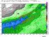
Clearly an uptick, you might be in a good spot...Here's the precip totals from the 18z gfs. If this verifies, I'll take my chances.
View attachment 13869

Sent from my SM-G950U using Tapatalk
Clearly an uptick, you might be in a good spot...Here's the precip totals from the 18z gfs. If this verifies, I'll take my chances.
View attachment 13869


Bama model shows 13 degrees in my backyard at 8AM Tues as the snow winds down after about 2 inView attachment 13873
View attachment 13874
don't discard Baron lightly...their products rock...even if it's a little overdone, it's something to take note of.. and it's been consistent with the snow amounts and temps, unlike most of these other modelsNothing supports those temps . Seems way overdone
Sent from my iPhone using Tapatalk
don't discard Baron lightly...their products rock...even if it's a little overdone, it's something to take note of.. and it's been consistent with the snow amounts and temps, unlike most of these other models
I know, I just commented on that..it's been consistent and it's great products. I'd just watch for lower temps than forecast even if that is a little low.I’m not talking about the snow amounts I’m talking about the temperatures. There isn’t anything even in the same ballpark that supports that
Sent from my iPhone using Tapatalk
Fresh arctic air plus a snow pack ... I beg to differ seems legitNothing supports those temps . Seems way overdone
Sent from my iPhone using Tapatalk
It also looks like N AL and N MS are getting their QPF reduced for that reason.Agreed. The precip enhancement across the gulf has translated to a better look further south into Alabama and also gives Atlanta and central NC a better shot at seeing snow.


Wouldn't be surprised. Roxboro jackpots in every NC winter storm. I think RDU could pick up a dusting if we're lucky.
I wouldn't put too much trust in that model. The FV3 kinda sucks to be honest.18Z FV3 appears to have a larger area of snow Tuesday Morning.
Am I looking at it incorrectly.
Fine with me im right over by the polk paulding lineI think Haralson or Polk County in GA will be the jackpot in GA, outside of the mountains.
I think 1-2" is a good possibility for you. It's almost always better to be west of Atlanta than east of Atlanta in most winter systems. I would hate to live in Rockdale, Newton, Walton counties, etc.Fine with me im right over by the polk paulding line


Slight improvements but we will take anything..... trends my friend trends.Gefs is getting interesting last minute for nc ?

anything? got tons of sloppy cold 43º rain we'd love to send ... LOLbut we will take anything
It appears that Forsyth will be right on the fringe of getting almost nothing and making the ground a little white. At this point in a winter that I have not seen a sleet pellet or flurry, I'll take a dusting and call it a win. It does suck that only a county or two to my west will probably get 1-2" but I'll take what I can get. 1-2 counties to my east will probably get nothing so I should be happy.
Thanks but no thanks, had my share of that this year.... enjoy it, in fact be selfish and keep all of it for yourselfanything? got tons of sloppy cold 43º rain we'd love to send ... LOL