• Hello, please take a minute to check out our awesome content, contributed by the wonderful members of our community. We hope you'll add your own thoughts and opinions by making a free account!

Wintry January 29th-30th ARCC Slam Dunk Winter Weather Threat

Can’t take the snow accum maps verbatim bro. The snow doesn’t know where those lines are drawn & furthermore give zero effs about them.
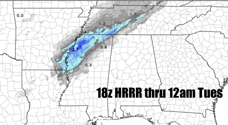
Semi-reverse psychology. Plus, better to not expect anything and be suprised than vice-versa. But for real, I don't expect enough snow to cover the ground here. I think the lee side effect will be in place with this; the dense cold air will have a tough time spilling over the mnts into this area and points east.
 
EF7A9412-0BC7-46D4-9584-8AAB88DF4EBB.thumb.jpeg.4a91e4b83636e589de865f25889c47e1.jpeg
 
It appears that Forsyth will be right on the fringe of getting almost nothing and making the ground a little white. At this point in a winter that I have not seen a sleet pellet or flurry, I'll take a dusting and call it a win. It does suck that only a county or two to my west will probably get 1-2" but I'll take what I can get. 1-2 counties to my east will probably get nothing so I should be happy.
Actually, FCC is calling for 1-2" of snow for Forsyth County.
 
I feel pretty sure the GFS has been under doing the moisture recently after comparing HRRR to GFS thru 12am Tuesday. :)
Widespread 2" snow amounts starting to enter AL on the HRRR is a good sign:

snow-1-27-19_zps0v0k3dfl.gif
The hrrr is extremely untrustworthy the further you get from hour zero. I think it’s best from about 6 hours or less. Many of us have hung our hopes on the hrrr before only to have things slowly correct to other guidance one run at a time. Typically, you want to use a blend of the best models, especially the hi-res nam.
 
This is a learning questions for me.Will the temperature profile support wet snow or Powder? Will this be a heavy wet snow or a dry snow? Could it start as a wet snow and as it gets colder will it "dry out"? Speaking of central Bama.
 
The hrrr is extremely untrustworthy the further you get from hour zero. I think it’s best from about 6 hours or less. Many of us have hung our hopes on the hrrr before only to have things slowly correct to other guidance one run at a time. Typically, you want to use a blend of the best models, especially the hi-res nam.
I know at 18 hours out it has always been the best model here in N. AL for snow. Perhaps it's not as good at 36 hours out, but it also might be picking up on some small mesoscale features which the other models haven't picked up yet.
 
Last edited:
This is a learning questions for me.Will the temperature profile support wet snow or Powder? Will this be a heavy wet snow or a dry snow? Could it start as a wet snow and as it gets colder will it "dry out"? Speaking of central Bama.
It will be a "wet" thick snow, especially with convective snow bands, which can produce heavy falling snow. A good amount a snow can fall in a short period of time with those convective snow bands. This is why some areas could get 2-3" max.
 
Last edited:
I’m about to reference 3/1/09 and I know it’s a completely different setup, but similar duration, it wasn’t long lasting but a pocket in East Alabama around Lee County got 5” from a convective band.

That ULL came from Michigan. We had a tornado warning in Salem, AL and 24 hours later had 6 inches on the ground. It was crazy.
 
I would imagine will see the euro increase things just a little bit and or drop temperature is a little as well that has been the trend on the Nam and GFS today at least for Georgia
 
Only problem may be that layer, this was what arcc mentioned and I’ve seen it before where that warm layer lags a little, other than that this is what it looks like when things switchover, when that change happens that will likely be some pretty heavy wet, sleety type snow (btw this is a sounding from central AL E6BDC466-3715-4A78-B256-F5956FD77DD4.jpeg
 
I'm guessing 1/2-2" for most of ATL area. My best guess is ~1/4" of liquid equiv. but not all will translste to accumulating snow or snow, period .It appears it will last only for ~3-5 hours at most. So, there could be a period of ~1"/hour snow at the peak...i.e., pretty substantial.

I'm guessing KATL will get ~1".

Edit: I mean entire precip to last no more than 3-5 hours, some of which would be snow. So, maybe 2-3 hours of snow at most?
 
Last edited:
I'm guessing 1/2-2" for most of ATL area. My best guess is ~1/4" of liquid equiv. but not all will translste to accumulating snow or snow, period .It appears it will last only for ~3-5 hours at most. So, there could be a period of ~1"/hour snow at the peak...i.e., pretty substantial.
Yeah if we see some heavy convection embedded in the line of snow, we could see some high rates. I've seen a convective snow shower put down a quarter of an inch in 10 minutes before, so if we see similar rates, someone could get a solid few inches.
 
My mean increased over 0.5, max is 2.5 lolol, early this morning my mean was barely over .10, really want to see if the NAM follows the trend of dropping more snow west and east of the apps
 
Yeah if we see some heavy convection embedded in the line of snow, we could see some high rates. I've seen a convective snow shower put down a quarter of an inch in 10 minutes before, so if we see similar rates, someone could get a solid few inches.
So I’m assuming this is essentially a winter equivalent of a squall line?
 
SREF Mean up to 2.52 for Birmingham. 8 members over 3 inches and two of them right around 6. Interesting that it keeps climbing
Check Shelby County Airport(eet) I can see everything but tot snow fall. Wanting see if it was just me or the site.
 
I'm guessing 1/2-2" for most of ATL area. My best guess is ~1/4" of liquid equiv. but not all will translste to accumulating snow or snow, period .It appears it will last only for ~3-5 hours at most. So, there could be a period of ~1"/hour snow at the peak...i.e., pretty substantial.

I'm guessing KATL will get ~1".

Edit: I mean entire precip to last no more than 3-5 hours, some of which would be snow. So, maybe 2-3 hours of snow?
Larry, I love to see your posts because I've followed you for years and years on these boards and know you are straight to the point, no bs or hype. Not trying to be too IMBY but how badly do you think the apps will prohibit the cold air from getting to Forsyth Co. NEward? That is my fear. The arctic airmass will be very cold and dense and will have trouble manouvering through the apps so it will take longer for us in NE Metro ATL.
 
Back
Top