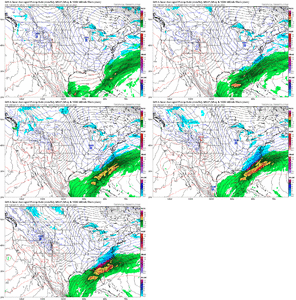
wow
Member
This is more of a fold to the rest of the models but not by much! All about the northern stream interaction.
Yep for once can watch the Nam and rgem for precip expansion and not sleet line 200m north of globalsReally like where this is for the 85 corridor as we start getting into short range models lead
So on the last storm, the Canadian was considerably colder than the rest of the models -- that didn't really verify, did it? Obviously makes a huge difference in the Florida panhandle/south Georgia/coastal S.C. in terms of cold rain vs. ice/sleet.
So on the last storm, the Canadian was considerably colder than the rest of the models -- that didn't really verify, did it? Obviously makes a huge difference in the Florida panhandle/south Georgia/coastal S.C. in terms of cold rain vs. ice/sleet.
Jason Simpson mentioned 17:1 north central alabamaRatios likely higher than 10:1 in the north of this
Sent from my iPhone using Tapatalk
Completely agree. If we continue to move towards a consensus on the globals, look for amounts to ramp up to the north and west as we approach go time. This isn't even just about precedence or a feeling (which you obviously know), it's about synoptics and mesoscale meteorology. Overrunning is always underdone on globals and especially in the presence of a powerful right entrance region to an upper level jet.Listen, at less than 4 days out, this is place to be for the I-85 crowd. There is lots of precedence for models to underplay the phasing until we're only 48 hrs away for a setup like this. Getting enough energy injected into it to turn that trough axis neutral and BOOM.
Honestly I'm liking this setup even though it's far south currently. We are close enough to a phase it's very possible still. If we get the energy just right it will be an absolute explosion. I don't think this will remain coastal for much longer.Listen, at less than 4 days out, this is place to be for the I-85 crowd. There is lots of precedence for models to underplay the phasing until we're only 48 hrs away for a setup like this. Getting enough energy injected into it to turn that trough axis neutral and BOOM.
I think the Canadian has issues with surface temps being too low and thus overdoes ice storm amounts. Or at least that used to be an issue and if the last storm is anything to go by, it still is.
And the midlands of SC. Warm nose please stay back.The arch-nemesis of ENC snow is slowly creeping back on the GFS ...
Long way to go, but this book has been seen a million times. You do NOT want to be in the bullseye at day 3-7. Your heart will get ripped to pieces. Typically it's the 85 or I40 crowd that deals with this, but in this instance.Seen this movie a time or two
View attachment 164593
The hint of a dual jet structure would agree to that. Both the GFS/CMC have strong to intense FGEN banding right along the Carolina Coast. The GFS obviously looked warmer aloft (ZR coastal), however, soundings looked like a IP/SN sounding (pretty deep cold air dome up to 800mb)...Honestly I'm liking this setup even though it's far south currently. We are close enough to a phase it's very possible still. If we get the energy just right it will be an absolute explosion. I don't think this will remain coastal for much longer.
When this switched to more of a northern stream storm, this comes into play. It all comes down to the position of LP off the coast. Too far off the coast you don't have to worry about the warm nose but you also don't get the qpf. Closer to the coast you'll have the high qpf but will have to watch the warm nose. It's a fine line but that's how you get the big storms in central NC.The arch-nemesis of ENC snow is slowly creeping back on the GFS ...
I think a small part of the difference is the slower movement of some of the members. Either way, it's definitely juicing up.
i know a lot are talking about the NW trend....but I really dont think the physics allow the actual low to go but so far NW....now, the precip shield will make it appear its trending NW as the surface lines up w the 500 VORT. IMO this is a 50-100 mile off shore NE to ENE slider

