lexxnchloe
Member
CFS has been rock solid with thisWell, we made it through the 12z models much better than I was expecting. @rburrel2 here's the CFS for your chart. It's on board!


CFS has been rock solid with thisWell, we made it through the 12z models much better than I was expecting. @rburrel2 here's the CFS for your chart. It's on board!


It used to have the tendency to be the least amped and progressive model back in the day. Even more than the GFS. I'm not sure if it's had any upgrades, but I like the trend.

That is snow depth. According to this model, my hypothetical snow doesn't melt away until 2/4/2025. That's on the ground for almost 2 weeks. Insane.Well, we made it through the 12z models much better than I was expecting. @rburrel2 here's the CFS for your chart. It's on board!

.LONG TERM...
(Saturday morning through next Wednesday)
Issued at 251 PM EST Thu Jan 16 2025
A dreary start to the long term (Saturday) is expected with periods
of widespread light to moderate rainfall across much of the forecast
area through the day. A lack of surface instability or notable upper
level support should negate any thunder chances overall. Rain
chances will gradually come to an end from west to east Saturday
night as the system exits eastward. A rain/snow mix is not out of
the question at the highest elevations in northeast GA as
temperatures begin falling late Saturday night. Another wave of
energy swings through the base of the trough on Sunday and may
support post-frontal cloud cover and a low chance of flurries in
North GA during the afternoon. By Sunday night temperatures plummet
and frigid temperatures look to stick around through at least mid-
week...
Early next week, the forecast area becomes situated near the base of
a very broad 500mb trough. At the surface, latest global ensembles
are painting a strong arctic surface high sliding south into the
north-central CONUS by early next week. Energy rotating through the
base of the broad trough will act to reinforce the colder air which
looks to stick around through at least mid week next week. At the
time of this writing, we`re looking at temperatures Monday and
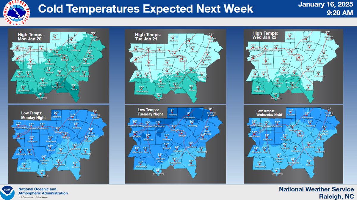
Tuesday 20 to 25 degrees below normal! Early morning temperatures
Monday through Wednesday are forecast to be in the teens to low 20s
and forecast daytime temperatures ranging from the mid 20s to mid
30s. Many locations (a line north of LaGrange to Griffin to Athens)
will struggle to rise above freezing. Breezy winds will not help the
situation at all keeping wind chills (aka the `feels like`
temperature) in the teens to single digit values Monday through
Wednesday. We are in the midst of winter and now is the time to prep
for the cold! Pipes, plants, pets and people!
Finally, the thing on everyone`s mind -- will another winter storm
impact portions of North and Central Georgia? Right now a few things
we can say...
-Latest deterministic and ensemble guidance is still highly
inconsistent with the bulk of the difference in outcomes depending
on the 500mb pattern. As we know here in the south, that placement
of upper level features as well as moisture can make or break a
winter wx forecast and is really what leads to the difficulties
surrounding it.
-Regardless of winter precip -- VERY cold and frigid temperatures
are highly likely next week. Please prepare now.
The pieces of this potential winter weather puzzle will continue to
come together in the coming days. So stay tuned for details
including exactly what, where, and how much...
&&
.AVIATION...
(18Z TAFS)
Issued at 1228 PM EST Thu Jan 16 2025
VFR conditions with SKC through the forecast. West winds will gust
to 24-28kts this afternoon before decreasing to 4-8kts after 23Z.
Light NW winds Friday morning will shift to SSE 4-7kts after 19Z
Friday.
No shocker there. They obviously think they know more than any of us all looking at the models. They are going to ride cold and dry until the bitter end and only forecast winter precip until they have to. I guess they have to have every model showing something but they are always so conservative when It comes to winter weather. I hope they can get brought back down to earth one day with a good snow storm.GSP says we are trending drier for next week. How much drier can you get when they already forecasted cloudless skies? Are they not looking at any models?
Navgem has a flat bias, go on ahead and bump that baby NW oh, say, 150 miles
I think a lot of the old school forecasting has given way to model watching. I'm not saying these guys do that. I don't know. But there's a lot of that that goes on out there, even in the pro world.No shocker there. They obviously think they know more than any of us all looking at the models. They are going to ride cold and dry until the bitter end and only forecast winter precip until they have to. I guess they have to have every model showing something but they are always so conservative when It comes to winter weather. I hope they can get brought back down to earth one day with a good snow storm.
If you go read the latest forecast discussion on NWS RAH you will see they only reference the Euro & GFS for their look ahead at this storm. They still are top scorers at this range--especially the 0z eps ens mean.I think a lot of the old school forecasting has given way to model watching. I'm not saying these guys do that. I don't know. But there's a lot of that that goes on out there, even in the pro world.
Agree 100% RC..you never hardly hear "Analogs" any more. I know they aren't gospel but a great forecasting tool imoI think a lot of the old school forecasting has given way to model watching. I'm not saying these guys do that. I don't know. But there's a lot of that that goes on out there, even in the pro world.
Model watching has become a very big thing, especially for broadcast meteorologist. I know we give him a hard time but Brad P is one of the best at being able to look beyond the models and can look at the entire picture to make a prediction. My local guys on all 4 stations are entirely fixated on models and what they show. And yes that includes Chris Justice who I really like and tends to be more hopeful when models show something good and the people at fox carolina who are quick to go to the worst outcome if the models even hint at no snow. It’s one reason I tend to be more hopeful. You start dropping troughs in California and the typical response is almost always amplification out east. Especially when the biggest driver here would be overrunning in that situation which itself is notorious for NW trends.I think a lot of the old school forecasting has given way to model watching. I'm not saying these guys do that. I don't know. But there's a lot of that that goes on out there, even in the pro world.
CAE with a good AFD on next week's potential:
.LONG TERM /SUNDAY THROUGH THURSDAY/...
- A very strong cold front arrives late Sunday as the lingering
surface low lifts northeast.
- Temps 15-25 degrees below average expected Monday through Thursday.
- Wintry precip chances continue for mid-week, but confidence
remains low.
The aforementioned surface low will lift northeast Sunday, followed
by the long discussed cold front. So there will not likely be
much of a diurnal swing Sunday as strong advection arrives
during the day. For Monday and Tuesday, the broad trough of the
Arctic airmass will settle into the central and eastern US. EC
and NAEFS are in excellent agreement over the general nature of
the initial airmass with highly anomalous cold, but not record
setting; temps 15-25 degrees below average yield highs in the
~30`s or low 40`s, along with overnight lows in the teens or low
20`. EC EFI continues to show EFI values between 0.9 and 0.95
Monday and Tuesday, but SoT is very low; a classic high
confidence in well below average, but not extreme temps, signal.
Regardless, the LREF output suggests we will approach or exceed
Cold Weather Advisory criteria at some point next week, so stay
aware of that potential new product issuance. Frozen pipes and
related impacts are becoming more likely during the mid- week
period as high temps will only make it above freezing for a few
hours each day.
Late Tuesday and into Wednesday is when the wintry precip potential
starts to enter the picture. Based on the last handful of guidance
suites, there is only a little more clarity on the possibility of
winter weather next week. Based on extent of the cold airmass and
associated surface high pressure, a suppressed low track
solution looks more and more likely with any wintry precip
chances actually increasing the further south you go in the
Midlands and CSRA. GEFS, and ECE to a lesser extent, have
trended towards this solution over the past several runs with
probabilities of 1" of snow in the central and northern
Midlands decreasing notably as the surface high settles into the
TN Valley. The GEFS and deterministic GFS remain the most
suppressed, with little-no precip into the forecast area. The
Canadian and at its ensemble are the other end of the spectrum,
with a northern GoM oriented storm track and significantly more
moisture overrun into eastern GA and SC; the EC and its
ensemble looks to be directly in the middle of these two
solutions over the last fews suites. The key feature of the
forecast is how the low level cold air and surface high pressure
is handled and how far southeast it can reach. How this high
pressure progresses is a result of extremely strong confluence
along the western flank of the trough main trough. And how this
confluence progresses is a result of a cutoff low in the Pacific
and its interaction with the main trough. A faster phase of
this cutoff drags the surface high further west, and a slower
phase causes the opposite. Unfortunately with chaotic nature of
cutoffs sitting under ridge axes, it will take several more days
to get consistent model guidance on this event. But generally,
the GFS-EC solution of a slower decay of the cutoff-ridge
pattern in the Pacific is more likely given typical model biases
in blocking patterns.
Overall, the forecast hinges on a notorious synoptic scale
interaction. But beyond that the general pattern is favorable
with a suppressed GoM storm track solution looking likely.
Whether that yields snow- wintry precip into the Midlands and
CSRA is highly uncertain at this time.
If you go read the latest forecast discussion on NWS RAH you will see they only reference the Euro & GFS for their look ahead at this storm. They still are top scorers at this range--especially the 0z eps ens mean.
Good catch, I hadn't seen that.RDU hasn’t updated the AFD for next week since 3am this morning
Sent from my iPhone using Tapatalk
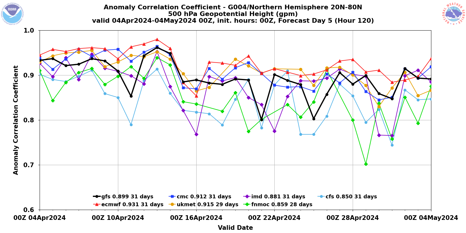
I wanted to re-post the latest H5 scores. For a time, the UKMET has been right up there with the Euro lately and the CMC as of late had a bad run along with the GFS. You can see how inconsistent it is, whereas the UKMET and Euro are typically the best.If you go read the latest forecast discussion on NWS RAH you will see they only reference the Euro & GFS for their look ahead at this storm. They still are top scorers at this range--especially the 0z eps ens mean.

| 00z Euro Ens mean: 8.47 | 8.5 |
| 00z Euro Control | 8.3 |
| 12z GFS Ens Mean | 8.2 |
| 12z GFS Control | 8.0 |
| 00z GFS Ens Mean | 7.9 |
| 00z Ukmet | 7.9 |
| 00z GFS Control | 7.5 |
| 00z Canadian | 7.3 |
It is ideal 5 days outView attachment 164252well this isnt ideal
What happened to all the ice ? Now it's just rain or snow ?View attachment 164252well this isnt ideal
not the same setup where we're just waiting on some 100 mile jog NWIt is ideal 5 days out
Maybe the result of being more of a Miller A setupWhat happened to all the ice ? Now it's just rain or snow ?
It absolutely is.not the same setup where we're just waiting on some 100 mile jog NW
Not digging as much compared to 12zView attachment 164259
Todays 12Z GFS At 84hr
