Snowlover34
Member

There are model runs and then there is GEFS #17. Not liking the amped up members, far too early.
View attachment 163271
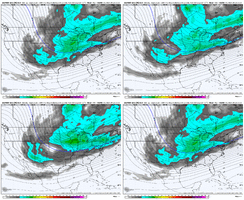
Then you got the EPS doing this… and even the latest 06z lookingGEFS dialed in with the WAR. Great zone opening up for a storm track View attachment 163288
GEPS not there yet but improving every run View attachment 163289

Yeah. If it winds up a amped up system , it will come northThis is about as classic a surface map as you will ever see for a SE winter storm. Strong HP moving in in tandem with a wave of LP from the Gulf with an arctic air mass in place. We need to thoroughly appreciate seeing these things when they're printed out.
View attachment 163290
17 is apocalyptic lol
Right now I'd definitely still lean ensembles for the general H5 pattern (good or bad trends) at this range. EC AI has been jumping around quite a bit so it's definitely not dialed in yet at this range.Then you got the EPS doing this… and even the latest 06z lookingView attachment 163292
Yes it did after a foot of snow with temps in the teensYou wanna talk about rates? Almost 12" falls in Charlotte in six hours then an inch of sleet on top of it.
One thing a lot of folks dont remember about 1988 is it ended as sleet.
Dang!!! I haven’t seen crazy runs like I’ve seen through the thread in years!!!! There was one model that always buried us on 384 hours.. forgot the name.. but geez!! This is next week!!! We couldn’t buy a fantasy run in the last couple years!come to papa
View attachment 163281
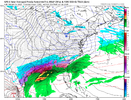
You could not ask for a better run.....amazing. It will change 100 times between now and then, but that is classic.Huge SE winter storm on the 6z GFS. Similar to other operational and ensemble runs we’ve seen.
View attachment 163256
View attachment 163257
View attachment 163258
This is about as classic a surface map as you will ever see for a SE winter storm. Strong HP moving in in tandem with a wave of LP from the Gulf with an arctic air mass in place. We need to thoroughly appreciate seeing these things when they're printed out.
17 is apocalyptic lol
Dang!!! I haven’t seen crazy runs like I’ve seen through the thread in years!!!! There was one model that always buried us on 384 hours.. forgot the name.. but geez!! This is next week!!! We couldn’t buy a fantasy run in the last couple years!
EPS looks good thoughYeah, the GFS seems keen on a system for sure, and that was a glorious 6z run. Makes me frustrated just seeing it knowing we haven't had one in 20 years. lol.
I too don't think a whiff/completely suppressed is believable. I've got to think with the trough to our west, and with a WAR, that we get a system with alot of qpf over the SE. What that does to the temps, don't know right now. But man if we have a 1040+ high in NY during go time like GFS, I'd be ALOT less worried.
Waiting on the EPS to tag in. It's looked pretty uninterested and suppressed the last couple days. Honestly GEFS honking isn't real until the EPS is.
00z EPS was honking about as loud as you could ever hope for at this range and lines up quite well with the 06z GEFS. Long way out, but I thought that was a big signal for a storm in general. If this signal holds or improves over the next 48-72 hours that would be a good sign we could be tracking something significant.Yeah, the GFS seems keen on a system for sure, and that was a glorious 6z run. Makes me frustrated just seeing it knowing we haven't had one in 20 years. lol.
I too don't think a whiff/completely suppressed is believable. I've got to think with the trough to our west, and with a WAR, that we get a system with alot of qpf over the SE. What that does to the temps, don't know right now. But man if we have a 1040+ high in NY during go time like GFS, I'd be ALOT less worried.
Waiting on the EPS to tag in. It's looked pretty uninterested and suppressed the last couple days. Honestly GEFS honking isn't real until the EPS is.


It showed winter storms over much of the SE a few runs prior, so which "Euro" do you believe?The Euro shows nothing and I trust the Euro over the GFS.
Just a troll. I've learned to mute them and move on. That "ignore" button has extreme power to continue to make this board enjoyable.It showed winter storms over much of the SE a few runs prior, so which "Euro" do you believe?
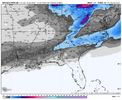
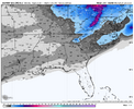
Correct me if I’m wrong, but wouldn’t the subtropical ridge get beaten down some by the STJOnly thing about the AIFS that I complain about it the weakness of the S/W and how strong the subtropical ridging gets on the SE, so it’s a ice event rather then snow View attachment 163283View attachment 163284View attachment 163286
I never had sleet here with that storm!Yes it did after a foot of snow with temps in the teens
GSP actual ended it with a period sleet and then a bit of ZRI never had sleet here with that storm!
It almost shocks me that areas to my NE did.
I promise you don't want to see the tweaks happening yet. This needs to stay right where it is another 3 days at least IMOICON is suppressed at 180 hours. 700mb winds were out of the west southwest but then shifted to west northwest at 180 hours. No over-running is gonna happen there. View attachment 163310
