ForsythSnow
Moderator
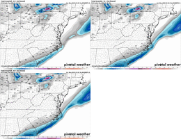
HRRR coming in a lot more moist north it looks like. Don't think it has the plane data yet either.
Haha If that came to be all models need to be thrown
Moisture surging northHRRR warming up in much of south Bama/Ga./Florida
It has improved but not nearly as much as others but it's been stubborn so any movement NW on it is good imoHey @RBR71 how do the MOGREPS look? The UKMET has yet to fully jump on board.

Whoa. Still got time to get that a couple more counties in. That’s a big deal to have Dr Nobot make a move like that
You think you’ve got a good chance of getting an inch of pure powder?
Precip on this filling back to N Miss.
That's what I am talking about. Brings a lot of moisture to N. ALA
Sleetfeast and I’m ok with that.This map is OBSCENE. This is a HRRR map!! Showing 7.6” in PCB!
View attachment 166039
Well realistically probably keep fingers crossed for a continued northward stream of qpf and maybe sneak a inch of super dry snow.... But who knows maybe the hurricane hunter measuring data in gulf and ground truth to our west overperforming and bunking modelsImma be honest I live in north metro atl and I was hoping for like 4 inches. But I feel like at this point even if it does keep ticking north, realistically it won’t actually change anything for me. But I guess you never know. (somebody give me encouragement)
That's insane. This going to over perform to the point where people are going to be unprepared.
Geez that gets us some up here in nw bama.wtheck?
No, I think this is going to stay just east of Wake county. We find creative ways to miss…last week missed 2-4” by 30-40 miles and will miss 2-4” to SE by 30-40 miles.You think you’ve got a good chance of getting an inch of pure powder?
Was this predicted?? And is it making to it the ground?
Plzzz don’t get my hopes up! When could we see this start to dry up, if it even does?That's insane. This going to over perform to the point where people are going to be unprepared.
That's a question for someone with letters behind there name. Between radar and the latest EURO AI, things are unticking in our areaPlzzz don’t get my hopes up! When could we see this start to dry up, if it even does?
That’s going to be a lot of sleet I’m afraidThis map is OBSCENE. This is a HRRR map!! Showing 7.6” in PCB!
View attachment 166039
You can see the drastic change. I think this is plane data View attachment 166044
Doesn't even show the full extent of the moisture lol.Nam is STILL adjusting View attachment 166045

Snow in s car before the stormYou can see the drastic change. I think this is plane data View attachment 166044
