NBAcentel
Member
This is making the home folks in Hope Mills happy.Took longer than I thought to finally see this but the classic last second NW shift is happening leading into this overrunning event.
View attachment 165924
Bruh!!
Holy smokes that was almost the exact same lead time too. WowLook similar ? View attachment 165930
IIRC, it verified even a little further West than that, correct? It's interesting because that last panel is pretty much at the same time range as the 18z runs are today. I know I got some flurries from that system and my notes say Spartanburg got an inch.Look similar ? View attachment 165930
yes it did I believe. We had very heavy snow in CNC a few hours after it startedIIRC, it verified even a little further West than that, correct? It's interesting because that last panel is pretty much at the same time range as the 18z runs are today.
IIRC, it verified even a little further West than that, correct? It's interesting because that last panel is pretty much at the same time range as the 18z runs are today. I know I got some flurries from that system and my notes say Spartanburg got an inch.

I saw a mid Atlantic met mention in the post storm model analysis from yesterday’s storm that the actual frotogenesis band setup 30 miles further north than all of the models. Do you see something similar happening for us, or is the placement a bit of a wild card?I’m going to press x doubt that this is going to be just light snow or virga for most of East-Central NC. There’s going to be some moderate to heavy rates wherever snow occurs.
This pivoting band of low level frontogenesis on an initially advancing low to mid level warm front, then a crashing cold front, argues for a lot more than just light snow.
This could easily put down a few inches or more if you get stuck under that. Models currently advertising that to setup shop near the I-95 corridor.
View attachment 165929
Yes back towards the foothills ended up with 1 inch. CLT got 2 and I got 2.7IIRC, it verified even a little further West than that, correct? It's interesting because that last panel is pretty much at the same time range as the 18z runs are today. I know I got some flurries from that system and my notes say Spartanburg got an inch.
Holy smokes that was almost the exact same lead time too. Wow
Yep. Chose those panels because that was the exact lead time as this setup, where we starting seeing drastic shifts west, and columns getting more moistIIRC, it verified even a little further West than that, correct? It's interesting because that last panel is pretty much at the same time range as the 18z runs are today. I know I got some flurries from that system and my notes say Spartanburg got an inch.
The NAM painted a similar area with 6”+ at 18z, I think. Gotta love a model moving a spot from a coating to 6”+ of snow in six hours at a <D2 lead.
Man, that stuff just misses Wake county
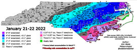
I got about .5" for the 2022 -21/22 storm in the Southern foothills.Yes back towards the foothills ended up with 1 inch. CLT got 2 and I got 2.7
If they're smart, they will wait until 3AM, if not 12z tomorrow or so.I'm expecting the national weather service center from Columbia to issue atleast winter weather advisories for the I-20 around Augusta and Columbia within the next couple of hours. Models are trending towards atleast a light event if not more.
All these years watching good snows in Wake county lost by only county to the NW trend, you would think we might finally get a county bump in our favor?Man, that stuff just misses Wake county
One can hope. If this busts and only eastern NC cashes in it’s gonna feel worse than yesterday. Hope we all get itAll these years watching good snows in Wake county lost by only county to the NW trend, you would think we might finally get a county bump in our favor?
I saw a mid Atlantic met mention in the post storm model analysis from yesterday’s storm that the actual frotogenesis band setup 30 miles further north than all of the models. Do you see something similar happening for us, or is the placement a bit of a wild card?
FWIW where this still shows zilch .... at 10PM that night I had 1.5" On the ground in Mooresville and Stanly county got 2-3"Look similar ? View attachment 165930
Storms never like to slide off the SE coast without Gulf Stream resistance - but there will be limits to the inland jogCheck out the 3km NAM IR trend.
View attachment 165942
Tilt, equals more QPF into orientation / column ect. HP weakening allowing slight ticks West instead of bullying the LP into AfricaThis thread seems to be nothing but wishcasting atp. Can anyone explain based on what the models are currently suggesting as to why we could see more moisture/ NW trend? Or a repeat Jan of 2014?
This thread seems to be nothing but wishcasting atp. Can anyone explain based on what the models are currently suggesting as to why we could see more moisture/ NW trend? Or a repeat Jan of 2014?
Ik it may be banter but so help me god theres gonna be some elated or miserable humans in here in t-minus 15 min. Hopefully it atleast holds. Would love to see 50 miles more expansion N OR WestThe 18z GFS is rolling.
