beanskip
Member
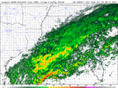
GSP/CLT back in the game if 18z NAM is, you know, sober.
Same rule as earlier applies.... youd have to think its a bit more filled in than this but good way to start eve session
Love it. Maybe FFC got an exclusive early showingOMG FFC may have the last laugh! NAM throws snow up into N. Ga. lol.
Yeah, the outline is there, but pretty anemic amounts this run. I expect it to fill in more over the next two model cyclesNot sure on amounts (probably pretty light), but the snow is seemingly significantly further N/W across NC at hr 30.
you can see with the more NW movement how it drastically reduces the snow on the GA and SC beaches and 95 corridor. More mixing.
Yeah, it’s hard to see getting more than an inch or so, even if this trends better. Wouldn’t hate seeing some snow on the ground with temperature below freezing all day on Wednesday, though. 1” is encroaching on Raleigh there on the 18z NAM.Yeah, the outline is there, but pretty anemic amounts this run. I expect it to fill in more over the next two model cycles
It’s virga but it’s there, snowing at a few thousand feetOMG FFC may have the last laugh! NAM throws snow up into N. Ga. lol.
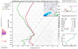
Virga is factored in and taken out of QPF. Of course, FFC had some discussion that models could be overestimating how much precip will be lost to virga, as well, which could argue for more than what the models are showing, but that’s above my pay grade. Some of these DPs progged on the modeling do seem unrealistically low, though.Question... those nam totals... would that include virga or what it expects to reach the ground?
  36 01/22 00Z   34     16     338       5    0.05  0.00    536    558   -8.8 -16.7 1028.4 100 -SN   045BKN112 120OVC228 251BKN355   37     34 20.0
42 01/22 06Z 28 22 38 10 0.09 0.00 536 558 -11.2 -16.5 1028.7 100 -SN 053BKN088 118OVC234 234OVC420 34 28 7.4Thank you.Virga is factored in and taken out of QPF. Of course, FFC had some discussion that models could be overestimating how much precip will be lost to virga, as well, which could argue for more than what the models are showing, but that’s sniff my pay grade. Some of these DPs progged on the modeling do seem unrealistically low, though.
Just watched the briefing. I Thought Keith did a great job explaining and illustrating the concerns FFC has with the modeling, and the possibility of column saturation getting precip to the surface (especially metro and to the north) that the models have struggled to reflect.Love it. Maybe FFC got an exclusive early showing
I’m proud of them for being different. Hope it pans out for them- don’t want to see them getting cooked online
Match the Kuchera ratios to the radar simulations for a quick analysis.Question... those nam totals... would that include virga or what it expects to reach the ground?
Yeah, it will catch up a bit by the 12z run tomorrow, but you can bet it will be one of the driest models.Knowing how stingy the 3km NAM is on the NW extent of precip...the .1" precip line will get back to CLT to GSO
View attachment 165911
Again tons of virga..Hopefully it can break through along that moisture axis3K NAM did tick north - but it’s well south of the 12km- big time improvement for CAE area thoughView attachment 165909

I am a few more tics away from legit business about 20 mile north of I 20 in West Georgia turn baby turnNeed that energy to dig more to move further south if we wanna see more forcing, we are getting there View attachment 165901
Honestly, what are the odds we see more of this and see the upper level DGZ produce and rip so much it completely blasts through the dry layer?I truly love this hobby
View attachment 165904

