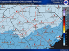
Are they using the “expected” amount for coloring but the 90th percentile amount as the upper bound on the labels? Bizarre map.This is a confusing map. Look at the colors and then the forecasted amounts. Columbia, for example, is shaded in the lightest shade which would indicate 0.1-1” but then it says <4”.
-
Hello, please take a minute to check out our awesome content, contributed by the wonderful members of our community. We hope you'll add your own thoughts and opinions by making a free account!
You are using an out of date browser. It may not display this or other websites correctly.
You should upgrade or use an alternative browser.
You should upgrade or use an alternative browser.
Wintry January 21-23 2025
- Thread starter SD
- Start date
Something wrong with this graph? <6" in places like Southern Pines and still others outside the heavy shading?? Did they give this a quality check before releasing?
They know something
Sent from my iPhone using Tapatalk
Drizzle Snizzle
Member
It looks very unprofessional.Something wrong with this graph? <6" in places like Southern Pines and still others outside the heavy shading?? Did they give this a quality check before releasing?
albertwilsonjr
Member
One thing I'm seeing over the upstate that models are NOT picking up on is the Forcing Mechanism with this. The WAA will likely produce some precip over the upstate and That alone could create a .5" to 1" of Snow. That may very well be what the NWS and WPC is Thinking. This is what I am now thinking cause I could very well see this scenario playing out across our Area. Let's see if models start picking up on that and expanding the Precip shield up into our area.
Sent from my iPhone using Tapatalk
Sent from my iPhone using Tapatalk
packfan98
Moderator
Gfs looks a little worse with more separation of the energy. Northern stream not as far west as 6z at hr 45
I hope they know they need to fix their mapIt can and will change at some point (for better or worse).
Too much reading into the NWS maps.
For places like I20, CAE, even up to Newberry line, this thing has high bust potential on either side.
This is an absolute nightmare to forecast and whichever way the watches and warnings come out is going to be right and both wrong for some.
Reminds me of the whole Jan 2000 snow when no moisture was supposed to come inland.
dsaur
Member
My point forecast has gone up 10 percent chance daily and now it's 60 with a WSW. I'd call that a nw shift over time.Speaking as a homer - would take about a 60 mile shift on the NAM to bring significant impacts to ATL. So 60 miles in the next 60 hours. Feels pretty doable? But also not likelyView attachment 165478
SimeonNC
Member
I know, the precip, if any, will come during the overnight. I fear that since most of the public up here won't be expecting snow that if any falls and accumulates on the roads. They will get up in the morning and be blindsidedJan ‘14 was snowmageddon in ATL because the snow came down around lunch time after a normal morning commute. When businesses started letting their people go it was too late. The roads were already screwed upz.
They have come a long way. However, it was so cold I don’t think the salt would have done much.Atlanta didn't have adequate equipment /resources for brining the roads then either. Since that time they build massive salt storage tents all around the city, and the have a ton more trucks available to treat the roads.
Well this storm sure has trended in the wrong direction 
Gfs looking a little worse, no change w southern feature and cold press is a little harsher
1”<4” so the map is accurateThis is a confusing map. Look at the colors and then the forecasted amounts. Columbia, for example, is shaded in the lightest shade which would indicate 0.1-1” but then it says <4”.
DAWG4LIFE
Member
I honestly trust the NWS/NOAA more than any
They have come a long way. However, it was so cold I don’t think the salt would have done I had to drive home and that and thing that really screwed everything up was ….once the snow started falling and sticking immediately, businesses and schools decided …that was a great time to let everybody go home at the same time. Come pick up your kids ,release the buses to take kids home from school and … hey oh yeah, you can go home if you’re working also…all at the same time!
Sctvman
Member
TWC's point forecast for downtown CHS just upped things to 3-5" of snow and ice. It was 1-3. It still has 1-3 for James Island. Gonna be a crazy forecast
dsaur
Member
What people who laugh at Atl don't know is Atl is a city of hills and even people from Alaska can't drive on black ice up a steep hill, or even a slight incline, without road treatments and proper tire devices. Hard to drive when all you do is spin. People who laugh the loudest live where it's flat.Jan ‘14 was snowmageddon in ATL because the snow came down around lunch time after a normal morning commute. When businesses started letting their people go it was too late. The roads were already screwed upz.
well that's a bit anemic
AJ1013
Member
New Orleans jackpot I guess 
iGRXY
Member
until that N/S gets its act together this is thing is a wrap for anything decent north of I20, especially in SC and Georgia. I95 right now looks like the sweet spot. The central and southern upstate could see some flakes flying and I guess if you consider that a win, then so be it but unless we get the N/S to slow down and dig more to the SW the southern vort can only do so much on its on. FGEN WAA will over produce but it’ll likely be for the folks along I95
wow
Member
This is barely a storm now. What a disaster. Goes to show how much things have to fall just perfectly to get a memorable one.
Twister
Member
The NWS and WPC is seeing something nobody in here has a Clue About. If they didn't see and know something they wouldn't have put out what they put out.
Shaggy
Member
It shows how clueless models can still be in the long range. I've been doing this since the interest allowed us to watch models and every year I tell myself not to look past 7 days and every year I get suckered inThis is barely a storm now. What a disaster. Goes to show how much things have to fall just perfectly to get a memorable one.
The CMC lost all my respect with this one.
I don't know if its different samplings/analogs or what maybe its factoring heavily a NW/W shift just like NE storm that modeling has shifted the low 150 miles over past 3-4 runs and throwing Snow another 100 miles inland. Sadly if your chasing this northward cant look away and just forget about it because of how bad models have soon to do when it comes to Northern extent of stormsThe NWS and WPC is seeing something nobody in here has a Clue About. If they didn't see and know something they wouldn't have put out what they put out.
Shaggy
Member
Yeah it has stunk it up with the last two systems for eastern NCThe CMC lost all my respect with this one.
Webberweather53
Meteorologist
I wouldn’t be shocked if the GFS & CMC suites have over corrected southward here.
tlokpmalone
Member
The CMC lost all my respect with this one.
such a piece of ----Poof. What a terrible model
View attachment 165504
accu35
Member
FWIW more 12z gefs members are more expansive north with the snow
accu35
Member
Gefs slightly improved it seems with a either little more NW or moisture expansion
tlokpmalone
Member
Yeah but how much more north are they really going to go realistically. I’m in metro Atl Atl but the possibility that they trend like 100 miles north to give me decent snow is very lowFWIW more 12z gefs members are more expansive north with the snow
ITUSETOSNOW
Member
Ya never know man,,,2014 is going to happen.Yeah but how much more north are they really going to go realistically. I’m in metro Atl Atl but the possibility that they trend like 100 miles north to give me decent snow is very low
Regarding Snow Amounts:
Exact snow accumulation amounts remain uncertain at this time and
will vary greatly on the strength of the Gulf low and how far
north the mid-level moisture on the north side is able to advance.
The ECMWF and CMC ensembles continue to indicate significantly
wetter solutions than the notably drier GFS ensembles. The latest
forecast has seen a northwestward shift in the axis of highest
precipitation, but it should be noted that the highest snowfall
amounts remain south of the Atlanta metro area. Inner quartile NBM
guidance indicates snowfall totals of 1.5 to 2.5 inches in
central Georgia, with highest amounts in west-central Georgia
(including Columbus). Below are some probabilities at a few
locations for >1 and >2 inches of snow from the 01Z NBM run:
Probabilities of 1+ inch of snow
Columbus: 70% Macon: 55% Atlanta: 50% Athens: 45%
Probabilities of 2+ inches of snow:
Columbus: 55% Macon: 45% Atlanta: 40% Athens: 35%
However, it should be noted that the spread in ensemble members
remains quite large with respect to amounts. This is illustrated by
"reasonable lowest amount" (90% or 9/10 exceedence) probabilities
indicating no measurable snowfall and "reasonable highest amount"
(10% or 1/10 exceedence probabilities indicating as much as 6-8
inches of snow in some locations in central and west Georgia.
Given this large spread in ensemble members, deterministic
forecasts of snowfall will remain variable. Therefore, will
continue to recommend favoring probabilistic guidance over
deterministic.
This snippet is from the morning disco, but FFC is really leaning heavy on NBM for snowfall totals.
 forecast.weather.gov
Exact snow accumulation amounts remain uncertain at this time and
will vary greatly on the strength of the Gulf low and how far
north the mid-level moisture on the north side is able to advance.
The ECMWF and CMC ensembles continue to indicate significantly
wetter solutions than the notably drier GFS ensembles. The latest
forecast has seen a northwestward shift in the axis of highest
precipitation, but it should be noted that the highest snowfall
amounts remain south of the Atlanta metro area. Inner quartile NBM
guidance indicates snowfall totals of 1.5 to 2.5 inches in
central Georgia, with highest amounts in west-central Georgia
(including Columbus). Below are some probabilities at a few
locations for >1 and >2 inches of snow from the 01Z NBM run:
Probabilities of 1+ inch of snow
Columbus: 70% Macon: 55% Atlanta: 50% Athens: 45%
Probabilities of 2+ inches of snow:
Columbus: 55% Macon: 45% Atlanta: 40% Athens: 35%
However, it should be noted that the spread in ensemble members
remains quite large with respect to amounts. This is illustrated by
"reasonable lowest amount" (90% or 9/10 exceedence) probabilities
indicating no measurable snowfall and "reasonable highest amount"
(10% or 1/10 exceedence probabilities indicating as much as 6-8
inches of snow in some locations in central and west Georgia.
Given this large spread in ensemble members, deterministic
forecasts of snowfall will remain variable. Therefore, will
continue to recommend favoring probabilistic guidance over
deterministic.
This snippet is from the morning disco, but FFC is really leaning heavy on NBM for snowfall totals.
National Weather Service
GeorgiaGirl
Member
Gefs slightly improved it seems with a either little more NW or moisture expansion
Bit better in Bama, but even worse to the east though on dryness in comparison to the 6z on mean totals.
rburrel2
Member
My in laws live in Tybee Island, GA... and deep diving there it seems like they have a legitimate shot at 3-5 inches of snow. Probably worst case they get 1-2 inches of snow/sleet.
That has to be almost unprecedented and truly historic there I would think. They can never make it work b/c of boundary layer issues being surrounded by ocean water.
That has to be almost unprecedented and truly historic there I would think. They can never make it work b/c of boundary layer issues being surrounded by ocean water.
Literally CAE's discussion is a big "we have no idea". They're tired of the models flip flopping, as they call it, it seems.
I’d argue that CAE probably has one of the toughest forecast challenges out of anyone out there with this storm.Literally CAE's discussion is a big "we have no idea". They're tired of the models flip flopping, as they call it, it seems.


