-
Hello, please take a minute to check out our awesome content, contributed by the wonderful members of our community. We hope you'll add your own thoughts and opinions by making a free account!
You are using an out of date browser. It may not display this or other websites correctly.
You should upgrade or use an alternative browser.
You should upgrade or use an alternative browser.
Wintry January 21-23 2025
- Thread starter SD
- Start date
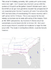
I hope so but that's not what the NWS at RDU thinks in their latest discussion. It was so long I couldn't cut, copy and paste it but they said it would be postively tilted. The adjectives flat and surpressed were in their discussion too. The NWS believes the low will eventually intensify when it gets into the Atlantic but too late to do central and eastern North Carolina much good. That is not good news for snow lovers but they did admit their forecast was low confidence.Looks like its going negative tilt. Might be too late who knows, but that's what Im seeing.
SnowDoomer21
Member
View attachment 165268
We’ll see how this ages.
Why you say that? Cause gonna be honest that’s wayyy to much I’m thinking 1-2 inches certainly not 3-4 but we’ll see I guess…
Sent from my iPhone using Tapatalk
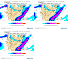
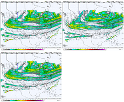
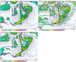
Latest Euro AI run not out yet, but here is EPS, then Euro, then Euro AI at 18z Tuesday
The southern wave thru TX is similar for all 3, but the northern trough thru Indiana is farthest west for the EPS and farthest east for the AI. It looks like the upstream kicker wave in western Canada is fastest on the AI, and the AI northern trough is the weakest (trough not as deep). So, fast and weak with the northern stream is no good for getting more precip north (as seen on the AI and probably the highly suppressed members on the EPS)
The southern wave thru TX is similar for all 3, but the northern trough thru Indiana is farthest west for the EPS and farthest east for the AI. It looks like the upstream kicker wave in western Canada is fastest on the AI, and the AI northern trough is the weakest (trough not as deep). So, fast and weak with the northern stream is no good for getting more precip north (as seen on the AI and probably the highly suppressed members on the EPS)

Webberweather53
Meteorologist
I'd like to pull a comparison. Keep note this was the Euro at 36 hours back in 2017.
View attachment 16525612Z Euro today
View attachment 165257
Subtle differenced with they key being the ULL in the PAC. Keep in mind how far up 2017 actually came to pass. From what I can tell even if we get bad. I'm very much focused on the NS and SW coming in. While this may not play out the same, this is a major reason I've not called anything yet.
Keep this thing in striking distance from a decent storm a few days out and I’m pretty happy with that, especially knowing how these usually trend in the short term. Dec 2017 one of the most prolific examples
Catfish
Member
So would you say Dec 2017 is a sold analog here? But this time with colder air in better climo?Keep this thing in striking distance from a decent storm a few days out and I’m pretty happy with that, especially knowing how these usually trend in the short term. Dec 2017 one of the most prolific examples
Sctvman
Member
Down here in the Lowcountry it’s crazy the difference in the forecast 3 days out. Could have 1/2” and it melts in a few hours or 8” and it’s here till probably the weekend. And so many people have moved here since 2018 they don’t know what to do particularly with ice and snow.
packfan98
Moderator
Well 18z euro AI didn’t change much. It’s bad. Such a bummer. Hopefully it will bounce back tomorrow.
Tokenfreak
Member
Yeah its going to be really interesting to see what actually happens. I was here during the snow storm in January 2018 where we got about 6" a little north of Charleston. I was also here in February 2010 where we got about 6" as well. Both of those times were rough in this area so I can't imagine possibly getting 8" especially with all these new people that have moved in over the years.Down here in the Lowcountry it’s crazy the difference in the forecast 3 days out. Could have 1/2” and it melts in a few hours or 8” and it’s here till probably the weekend. And so many people have moved here since 2018 they don’t know what to do particularly with ice and snow.
Now I don't want to come across as questioning the Raleigh NWS but I'm wondering if they are basing that discussion off of the information from the 18z GFS/GEFS?I hope so but that's not what the NWS at RDU thinks in their latest discussion. It was so long I couldn't cut, copy and paste it but they said it would be postively tilted. The adjectives flat and surpressed were in their discussion too. The NWS believes the low will eventually intensify when it gets into the Atlantic but too late to do central and eastern North Carolina much good. That is not good news for snow lovers but they did admit their forecast was low confidence.
Sent from my SM-S156V using Tapatalk
NBAcentel
Member
packfan98
Moderator
They mentioned all of the models including the euro aiNow I don't want to come across as questioning the Raleigh NWS but I'm wondering if they are basing that discussion off of the information from the 18z GFS/GEFS?
Sent from my SM-S156V using Tapatalk
packfan98
Moderator
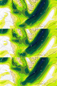
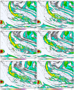
Rounding the bend enough to hit the northeast in future runs?AIFS last 3 runs View attachment 165272
Ahhh ok sounds good because when I saw suppressed and flat I'm like uhhhh the 18z GFS/GEFS was that but I didn't know they mentioned all the modelsThey mentioned all of the models including the euro ai
Sent from my SM-S156V using Tapatalk
That model has been consistent during the last three runs. Not consistently good for snow lovers but consistent none the less.AIFS last 3 runs View attachment 165272
lexxnchloe
Member
Looks to me like the moisture bumped a bit more NW.AIFS last 3 runs View attachment 165272
ForsythSnow
Moderator
It's trending away from flatter. We want to see this. I'd expect if this continues, a larger moisture pool will flow inland. A trend like that to me says it could be catching onto a more phased solution. If there's H5 maps, I'd think it's inching closer to a phase at some point.AIFS last 3 runs View attachment 165272
It did, barely scrapes mby at lowest shade blue, but gotta start somewhere. Orientation changes as well . I wish it would hug the coast an run the seaboardLooks to me like the moisture bumped a bit more NW.
AIFS last 3 runs View attachment 165272
Good trends.
BHS1975
Member
Yeah plenty of time if it keeps trending at that rate.Good trends.
NBAcentel
Member
NBAcentel
Member
Too good to be true lol. Exactly what we want if we still have a shot at the big dog.Since we analyzing everything, 18z HRRR vs 00z View attachment 165277
NEGaweather
Member


Sent from my iPhone using Tapatalk
SnowDoomer21
Member


Sent from my iPhone using Tapatalk
Is that the updated one? sorry I’m in the NWS Tallahassee forecast area
Sent from my iPhone using Tapatalk
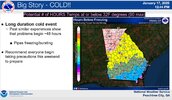
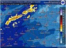
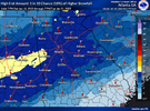
That map is kind of bizarre from this part of Georgia's perspective. We have about 25% chance of 2" of snow but they are expecting no accumulation at all. I figured we would be at least at a trace to less than one inch
Southern Track
Member
More N/S interaction?Since we analyzing everything, 18z HRRR vs 00z View attachment 165277
NEGaweather
Member
Is that the updated one? sorry I’m in the NWS Tallahassee forecast area
Sent from my iPhone using Tapatalk
Yes updated at 7:16
Sent from my iPhone using Tapatalk


Sent from my iPhone using Tapatalk
It says updated at 7pm.Is that the updated one? sorry I’m in the NWS Tallahassee forecast area
Sent from my iPhone using Tapatalk
This is only through 7 pm Tuesday, so it does not include the peak of the storm for areas in the east.


Sent from my iPhone using Tapatalk
albertwilsonjr
Member
Man those odds suck.
It’s only through Tuesday this storm will impact the upstate after 7pm on Tuesday into the overnight hours
Sent from my iPhone using Tapatalk
neelsamb
Member
IMO this is their way of saying “models are showing so many different possibilities we really have no clue what’s going to happen. We could get nothing but we could also get 8 inches.”That map is kind of bizarre from this part of Georgia's perspective. We have about 25% chance of 2" of snow but they are expecting no accumulation at all. I figured we would be at least at a trace to less than one inch
- Joined
- Jan 2, 2017
- Messages
- 1,566
- Reaction score
- 4,279
NBAcentel
Member
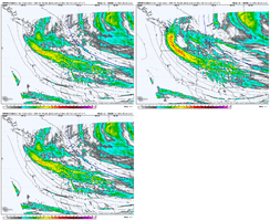
The 00z NAM is not as west with the digging pac energy so far just like the HRRR - this is gonna result in a less strung out Southern wave more then likely. But the northern peice dictates everything.
SnowDoomer21
Member
This is only through 7 pm Tuesday, so it does not include the peak of the storm for areas in the east.
My question is what time does it all go down like is that before or after the storm? So many questions
Sent from my iPhone using Tapatalk
NBAcentel
Member
- Joined
- Jan 2, 2017
- Messages
- 1,566
- Reaction score
- 4,279
Looks more like the 12z

