BKWRN29
Member
I think this thing will trend NW as we get closer! It reminds me so much of Dec 2017 for my area.

That conversation will come when they start in with precip amounts and placementIm surprised there hasn’t been more talk about ratios being higher for this system on the northern edge. It won’t take much qpf to lay down a couple inches which was part of the huge mistake Mets made in 2014
Sent from my iPhone using Tapatalk


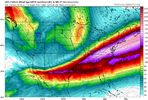
rain on the northwest edge? Must be rate driven stuffEuro also has this on Friday. GFS has had it on and off as well.
View attachment 165142
Seems like an issue with the light qpf in foothills/piedmont of NC is from the amount of low level dry air that has to be overcome. Dew points are a little higher back towards the upstate and N. GA. and I think that's the only difference between it showing .05-.1 and .01-.03.
I still think that qpf is being underdone, assuming the synoptics stay the same. Those fingers of precip streaking out ahead pretty much always over perform, and the jet dynamics aiding in that finger will be really good.
.2 or .3 of liquid is attainable of N. GA, UpstateSC, and Western/Central NC from that, even if we just simply hold the consensus/blend of (gfs,euro,nam/cmc) at 5h with no additional improvements.
And I personally think we're probably pretty locked in at 5h and it's going to be roughly what the 12z euro is showing.
But i'll still optimistically hope we trend a little more amped/connected to the southern wave like the NAM, and also skeptically worry we will trend to less northern stream digging. Fun times ahead!
I guess it just depends on how early the precip comes in on Tuesday ?It's still noteworthy how much warmer the gfs is across the southeast than virtually all other guidance.. as an example...it has it getting to 40!! here tue while all other guidance is subfreezing with the exception of the uk which is low to mid 30s. Indeed its 4 or 5c warmer in the low levels vs other guidance. Here is the gfs compared to the euro for comparison
View attachment 165141
View attachment 165140
Doubt it’s rain. Sleet or FR most likely.rain on the northwest edge? Must be rate driven stuff

Posts like these are not gonna age well. There’s always a NW trend no matter what. You better believe it will be showing in the models probably tomorrow.I don't think there will be too much of traditional "NW Trend", more like there will simply be more precip on the NW side and more precip in general. This could easily be one of those events where most of NC gets a light while somewhere in the coastal plain gets absolutely crushed
I don’t think there will be a drastic change to the path but I think there will be a slight NW trend, totals will increase north and likely decrease south or mixed precip to the south.I don't think there will be too much of traditional "NW Trend", more like there will simply be more precip on the NW side and more precip in general. This could easily be one of those events where most of NC gets a light while somewhere in the coastal plain gets absolutely crushed
Posts like these are not gonna age well. There’s always a NW trend no matter what. You better believe it will be showing in the models probably tomorrow.
I gotta agree with sim that it's gonna just be more of an extended precip field than the low trending more nw and more amped. But it's not totally out of the equationPosts like these are not gonna age well. There’s always a NW trend no matter what. You better believe it will be showing in the models probably tomorrow.

I gotta agree with sim that it's gonna just be more of an extended precip field than the low trending more nw and more amped. But it's not totally out of the equation
If everything goes right for us I think we can come away with 2-4 inches of powder.What kind of totals would this equate to for upstate
Sent from my iPhone using Tapatalk
Nope..this isn't precip related.I guess it just depends on how early the precip comes in on Tuesday ?


Looks similar to what the NAM was showing. Maybe a touch south of the NAM15z SREF!
View attachment 165150
Everyone will laugh but I bet this is the final footprint in the end.Bouncycorn does it again! I’ll take that general footprint all day long baby. Thanks for posting


15z SREF!
View attachment 165150
What’s going on at the coast??15z SREF!
View attachment 165150
The Model agreements for Alabama are impressive!15z SREF!
View attachment 165150
Yeah I would like where we are better if the bottom side of the modeling wasn't so bad (ukmet/euro ai/icon). UKMet here has the northern wave neutral tilt thru E Kentucky with the southern wave positive tilt thru C Texas. That's pretty terrible. 12z Euro AI was ever so slightly better with the overall trough tilt. Just gotta 'hope' somehow / some way that 500mb improves with hi res picking up on it. Columbia etc don't need much or any improvement, but different to the NW.If everything goes right for us I think we can come away with 2-4 inches of powder.
More realistically, I think it's fair to optimistically expect 1-2 inches with where things stand right now.
A complete whiff is still absolutely on the board though, we can't totally discount what the ukmet/euro ai/icon are showing even if we think they're wrong.