That high pressure feed is sexyNow this is the stuff I'm talking about!
View attachment 62198View attachment 62200View attachment 62199View attachment 62201
-
Hello, please take a minute to check out our awesome content, contributed by the wonderful members of our community. We hope you'll add your own thoughts and opinions by making a free account!
You are using an out of date browser. It may not display this or other websites correctly.
You should upgrade or use an alternative browser.
You should upgrade or use an alternative browser.
Pattern January 2021 - Joyless January
- Thread starter TheBatman
- Start date
Cross polar flow FTW? Or typical GFS LR headfake? Stay tuned!
Cad Wedge NC
Member
It's not like you to downplay a snow threat. You seem really confident that this is a DC / Baltimore storm. I would normally be excited to see all the models showing accumulating snow for MBY, but I am reserved.Don't really like the fact that we're also having to rely on dynamical cooling to push us down to freezing in light of how much warm advection there's gonna be. It would be one thing if we actually had the cold air in place prior to precip arrival.
NBAcentel
Member
black hole 
+PNA with a ridge nudging toward the pole up above Greenland. Recipe for absolute vodka cold.black hole View attachment 62202
whatalife
Moderator
Not lack of energy post 240 w/that cold around on the 18z GFS.
Sent from my iPhone using Tapatalk
Sent from my iPhone using Tapatalk
Webberweather53
Meteorologist
Yeah I don’t like this setup... yet.It's not like you to downplay a snow threat. You seem really confident that this is a DC / Baltimore storm. I would normally be excited to see all the models showing accumulating snow for MBY, but I am reserved.
I know this is the 18z but that look in the LR is so freaking amazing
NBAcentel
Member
This would be colder then jan 2018 lol 
RVD
Meteorology Student
I have to say I'm pretty shocked that this thing has trended so substantially SE. GFS says I get 6" per the maps posted by @Ollie Williams, but that's obviously suspect especially when considering it also says temperatures are in the mid-30s:

Accumulations could occur with this look but very inefficiently (another Feb 2020, but further north). Doesn't help that ascent is not maximized (and the cloud is a bit dry) in the DGZ.
One promising thing is the trend towards colder temps ahead of this system- in many ways, I suspect, a continuation of the warm bias we've seen in the medium to long range.

We'd need to see another few trends like this for temperatures not to be so marginal. Which is a big ask IMO, when anticipating a NW trend in the shorter term. This has gotten a lot closer than I thought it would.
We could also use the 850 mb low to be just a little bit weaker/further south on approach than it currently is- again a big ask if anticipating typical trends. But the GFS is really nice in that it develops a strong offshore 850 low which wraps up subfreezing temps really nicely, all the way to the coast. Really the problem by this point is surface temperatures, which are just a few degrees too warm. We'll see if we can pull a good trend at the surface out of our a$$es or not. Otherwise we're relying on latent heat absorption, which relies on heavier rates than we're seeing, which relies on strong forcing for ascent, which requires WAA.


Accumulations could occur with this look but very inefficiently (another Feb 2020, but further north). Doesn't help that ascent is not maximized (and the cloud is a bit dry) in the DGZ.
One promising thing is the trend towards colder temps ahead of this system- in many ways, I suspect, a continuation of the warm bias we've seen in the medium to long range.
We'd need to see another few trends like this for temperatures not to be so marginal. Which is a big ask IMO, when anticipating a NW trend in the shorter term. This has gotten a lot closer than I thought it would.
We could also use the 850 mb low to be just a little bit weaker/further south on approach than it currently is- again a big ask if anticipating typical trends. But the GFS is really nice in that it develops a strong offshore 850 low which wraps up subfreezing temps really nicely, all the way to the coast. Really the problem by this point is surface temperatures, which are just a few degrees too warm. We'll see if we can pull a good trend at the surface out of our a$$es or not. Otherwise we're relying on latent heat absorption, which relies on heavier rates than we're seeing, which relies on strong forcing for ascent, which requires WAA.
Attachments
Damn
Pensacola Punisher
Pensacola Punisher
Rain_Cold special!black hole View attachment 62202
NBAcentel
Member
Yeah those backside soundings are really good, it’s just the marginal surface tempsI have to say I'm pretty shocked that this thing has trended so substantially SE. GFS says I get 6" per the maps posted by @Ollie Williams, but that's obviously suspect especially when considering it also says temperatures are in the mid-30s:
View attachment 62191
Accumulations could occur with this look but very inefficiently (another Feb 2020, but further north). Doesn't help that ascent is not maximized (and the cloud is a bit dry) in the DGZ.
One promising thing is the trend towards colder temps ahead of this system- in many ways, I suspect, a continuation of the warm bias we've seen in the medium to long range.
View attachment 62193
We'd need to see another few trends like this for temperatures not to be so marginal. Which is a big ask IMO, when anticipating a NW trend in the shorter term. This has gotten a lot closer than I thought it would.
We could also use the 850 mb low to be just a little bit weaker/further south on approach than it currently is- again a big ask if anticipating typical trends. But the GFS is really nice in that it develops a strong offshore 850 low which wraps up subfreezing temps really nicely, all the way to the coast. Really the problem by this point is surface temperatures, which are just a few degrees too warm. We'll see if we can pull a good trend at the surface out of our a$$es or not. Otherwise we're relying on latent heat absorption, which relies on heavier rates than we're seeing, which relies on strong forcing for ascent, which requires WAA.
View attachment 62203
View attachment 62207
View attachment 62206

Would be so much better if we were dealing with colder air (temps around 25-30 during the event) rather then 32-38
The LR look definitely has the RC stamp of approval...exactly what I have been wanting to see us evolve toward. Hopefully, it's the real deal.Rain_Cold special!
BHS1975
Member
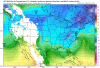
Now this is the stuff I'm talking about!
View attachment 62198View attachment 62200View attachment 62199View attachment 62201

Sent from my iPhone using Tapatalk
We were just stating about no cold on this side of the world , like 2 days ago! Great turnaround! Rooting for y’all!The LR look definitely has the RC stamp of approval...exactly what I have been wanting to see us evolve toward. Hopefully, it's the real deal.
Gfs version 16 (new) for my Carolina friends

Nice cold shot on regular gfs mid/long range. .png")
Last edited:
I am about to post a video update on my FB page. Yes, its been a while but going to do more video updates for sure.
DadOfJax
Member
Can you elaborate?
No, he cannot.
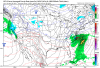
You posted the snow map.Nice cold shot on regular gfs mid/long range. View attachment 62212

We (I-20 crew) didn't score with the look we had in Feb 2015. Wasn't that a pretty good look ? My point is, no matter how good the look it is, it doesn't guarantee anything.
No, but close to I20 did. The February 2015 snowstorm pounded north of BHM with 9-12” of snow. I remember, because that one is number one on my hate list. Freakin NAM had to be right for once in a million tries....
NBAcentel
Member
Like this trend
Seems like there’s areas of energy that sorta “elongate” and extend away from the ULL and pulls it south

Seems like there’s areas of energy that sorta “elongate” and extend away from the ULL and pulls it south
This would be colder then jan 2018 lol View attachment 62208
So the TPV solidifies over our side of the world with a -NAO and +PNA. I’m ok with that.
B
Brick Tamland
Guest
Wow, and this is only about 5 days out now.
NBAcentel
Member
I wonder if we start getting any colder looks on the euro and more suppressed looks, our confluence is trending a favorable way 

Like this trend
Seems like there’s areas of energy that sorta “elongate” and extend away from the ULL and pulls it south View attachment 62213View attachment 62217
Maybe the 18Z ICON is on to something with that southern wave coming through the Baja tugging it south because it appears the 18z Euro is also feeling it as well.
DadOfJax
Member
No, but close to I20 did. The February 2015 snowstorm pounded north of BHM with 9-12” of snow. I remember, because that one is number one on my hate list. Freakin NAM had to be right for once in a million tries....
We were buried in Gadsden!
Dewpoint Dan
Member
Not a flake in Oxford !We were buried in Gadsden!

Six Mile Wx
Member


Man that’s a look from the Legends. The GFS dug deep in its archives for this.
L
Logan Is An Idiot 02
Guest
Anyone have the 18z Euro?
Sent from my Pixel 3 using Tapatalk
Sent from my Pixel 3 using Tapatalk
Six Mile Wx
Member
Anyone have the 18z Euro?
Sent from my Pixel 3 using Tapatalk

Six Mile Wx
Member
Anyone have the 18z Euro?
Sent from my Pixel 3 using Tapatalk

Six Mile Wx
Member
Anyone have the 18z Euro?
Sent from my Pixel 3 using Tapatalk

Montanasnow30
Member
I’ll never forget that one I still hate that system to this dayNo, but close to I20 did. The February 2015 snowstorm pounded north of BHM with 9-12” of snow. I remember, because that one is number one on my hate list. Freakin NAM had to be right for once in a million tries....
Last edited:
NBAcentel
Member
EPS is even colder so far at 18z ! More confluence from the 50/50 low 
NBAcentel
Member
Yeah this EPS run is gonna be much better than 12z
Clem282340
Member
It only goes out to 90 hrs correctYeah this EPS run is gonna be much better than 12z