L
-
Hello, please take a minute to check out our awesome content, contributed by the wonderful members of our community. We hope you'll add your own thoughts and opinions by making a free account!
You are using an out of date browser. It may not display this or other websites correctly.
You should upgrade or use an alternative browser.
You should upgrade or use an alternative browser.
Pattern January 2021 - Joyless January
- Thread starter TheBatman
- Start date
NBAcentel
Member
Very well could, if we get northern stream energy further ahead of it/stronger around the GL, could be a nice storm, plenty of time to trend either directions, euro was solid but it weakened the energy near the GL, but the CMC looked really good with thatI can’t wait to see what cmc does with this tonight. And the euro the track is near perfect maybe we trend colder
Sent from my iPhone using Tapatalk
NBAcentel
Member
That’s almost exactly how we need that N/S trough to look with the second system, or like the CanadianLet's give the GFS the benefit of the doubt and stop right here. This will do nicely.
View attachment 61872

NBAcentel
Member
LickWx
Member
Remember what I said , can’t play with fire and not get burned . Need to smell the 70 and sunshine before you can get the 32 and snow . It can be 70 and sunny and never get cold and snowy but it can never be cold without there being warm . Well 1977 but that was dry as hell and frigid , then the month after was really warm and hit 81. So I guess my rule still works .Of course when we get a legit arctic dump, we know where this is headed.... that NPAC/-EPO block = -PNA = southeast ridge View attachment 61868View attachment 61869
Yeah the gfs was about as bad as you can get if you want snow. Need something more similar to the euro/Canadian to have a shot. I mean it essentially is a split flow across NOAM at that point so we are probably going to see a few wild variations over the next few days. Wouldn't be at all surprised to get a wound up cutter and an overrunning event on the models as they try to resolve the wave interactionsVery well could, if we get northern stream energy further ahead of it/stronger around the GL, could be a nice storm, plenty of time to trend either directions, euro was solid but it weakened the energy near the GL, but the CMC looked really good with that
Dewpoint Dan
Member
Looks good for Brent.V16 throwing a bone for y’all west of the mountains View attachment 61876View attachment 61877View attachment 61878View attachment 61879
I'm just going to leave this here:
Miller A setups like what we may see a lot of in the coming month or two are much more tenuous imo than CAD or overrunning and are typically boom/bust type events with very limited predictability beyond day 4-6. Point is, going forward thru January & even February, don't get discouraged if you aren't seeing fantasy long-range snowstorms on ensemble guidance or operational NWP. These kinds of storms often sneak up on you at the very last minute (think Jan 2000, Dec 2010 for ex (although we've made some improvements since then)).
NBAcentel
Member
Cross polar ridge?Lol ridge from the west coast to Russia View attachment 61871
Interesting seeing GEFS pull ridge off the west coast. If that continues and we block it could be like Jan 2011.
View attachment 61883View attachment 61885
It’s nuts seeing the 500mb pattern like that yet have most of the US above normal at the surface. Why couldn’t they have left the GFS alone. Every time it gets a upgrade it gets worse and it wasn’t great to begin with.
Now you’re speaking my language!Interesting seeing GEFS pull ridge off the west coast. If that continues and we block it could be like Jan 2011.
View attachment 61883View attachment 61885
played golf today on a sponge. Place was packed. Walked ofF course 1/4 mile visibility at sunset. Made it to 50 degrees I think. Raleigh nws,GFS had us at low to mid 60s lol. Wedge was stout.
ajr
Member
Random -- do you know if MJO phase is uniformly distributed (e.g. is Phase 1 equally likely to Phase 6?)?
That’s almost exactly how we need that N/S trough to look with the second system, or like the Canadian
Glacier National Park is the benchmark for northern stream parcels with phasing potential, I’d like to see the leading wave over the west central Plains but it’s workable given the t-step. Heights though along the EC/MA are above spec.
I know that as of recent, the MJO is much slower, and I'm far from an expert on tropical forcing, but these is the probabilities:Random -- do you know if MJO phase is uniformly distributed (e.g. is Phase 1 equally likely to Phase 6?)?
https://agupubs.onlinelibrary.wiley.com/doi/pdfdirect/10.1002/2016GL071423#:~:text=The climatological percentage probability for,predictions of a strong MJO.The climatological percentage probability for each of the eight MJO phases is around 8% (~33% of the time the MJO is in its weak state), and thus, the green/blue color scale also indicates probabilities greater than climatol- ogy for predictions of a strong MJO.
Interesting seeing GEFS pull ridge off the west coast. If that continues and we block it could be like Jan 2011.
View attachment 61883View attachment 61885


Local forecast by
"City, St" or ZIP code
Location Help
News Headlines
- 2020 Central Alabama Year in Review
- Weather History: Arctic Outbreak of January 6-7, 2014
- Weather Science Content for Kids & Teens!
- Get Ready for Winter Weather Hazards by Visiting Our Winter Safety Website!
- Follow Us on Social Media!
NWS Birmingham, Alabama
Weather Forecast Office
Heavy Snow & Ice Event - January 9-10, 2011
Weather.gov > NWS Birmingham, Alabama > Heavy Snow & Ice Event - January 9-10, 2011
- Current Hazards
- Current Conditions
- Radar
- Forecasts
- Rivers and Lakes
- Climate and Past Weather
- Local Programs
On the morning of Sunday, January 9th, a low pressure system formed in the Gulf of Mexico just off the Texas coast. This low pressure system traveled parallel to the Gulf Coast throughout the day on Sunday and into the day on Monday before moving over the Florida Panhandle and off the Atlantic Seaboard Monday night. Even though the system weakened as it moved eastward, it brought moisture across Central Alabama, where cold temperatures were already in place from a cold front that had moved through Friday and Saturday, the 7th and 8th of January.
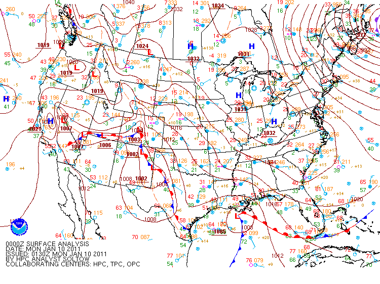
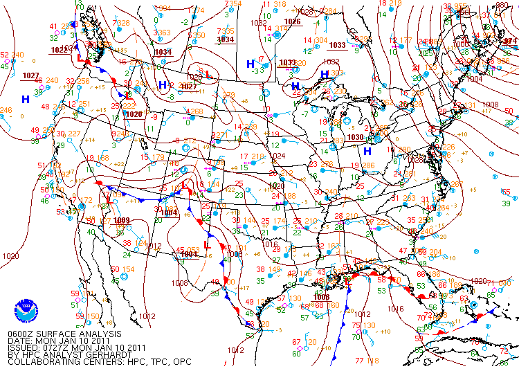
Surface Analysis from 6 PM Sunday Surface Analysis from 12 AM Monday
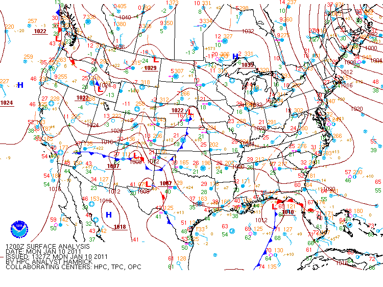
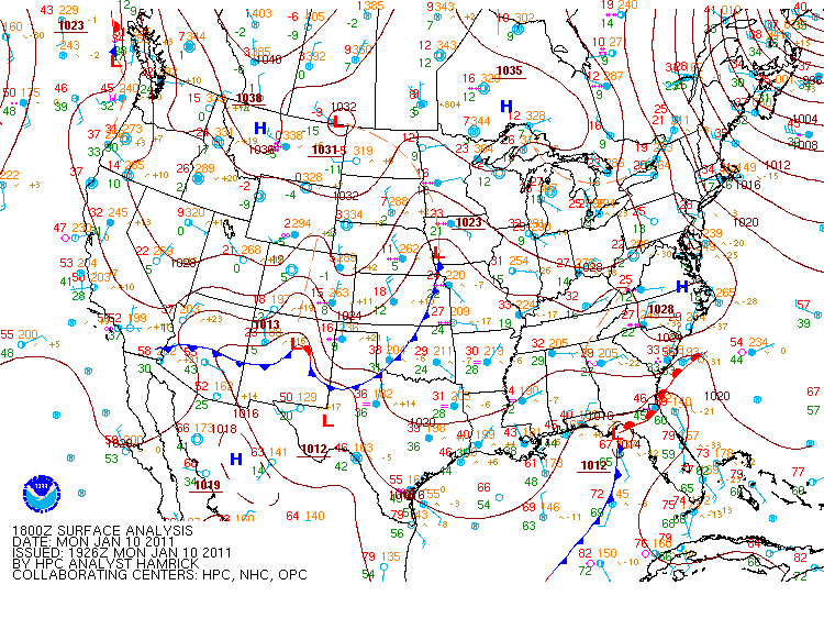
Surface Analysis from 6 AM Monday Surface Analysis from 12 PM Monday
By noon on Sunday, weak reflectivities were already on the radar, though, it wasn't until about 2 PM that afternoon when Tuscaloosa began reporting unknown precipitation. The bulk of the activity started later that evening, but because of an elevated warm layer of air that moved inland as the low pressure system passed to the south of Alabama, the southern half of the county warning area didn't receive any snow -- just ice and sleet. By daybreak Monday morning, areas north of Interstate 20 were reporting anywhere from 1 to 14 inches of snow with the heaviest totals near the Alabama-Tennessee state line. Ice reports were as high as 0.50 inches in multiple counties south of Interstate 20.
- Local Storm Reports from the event.
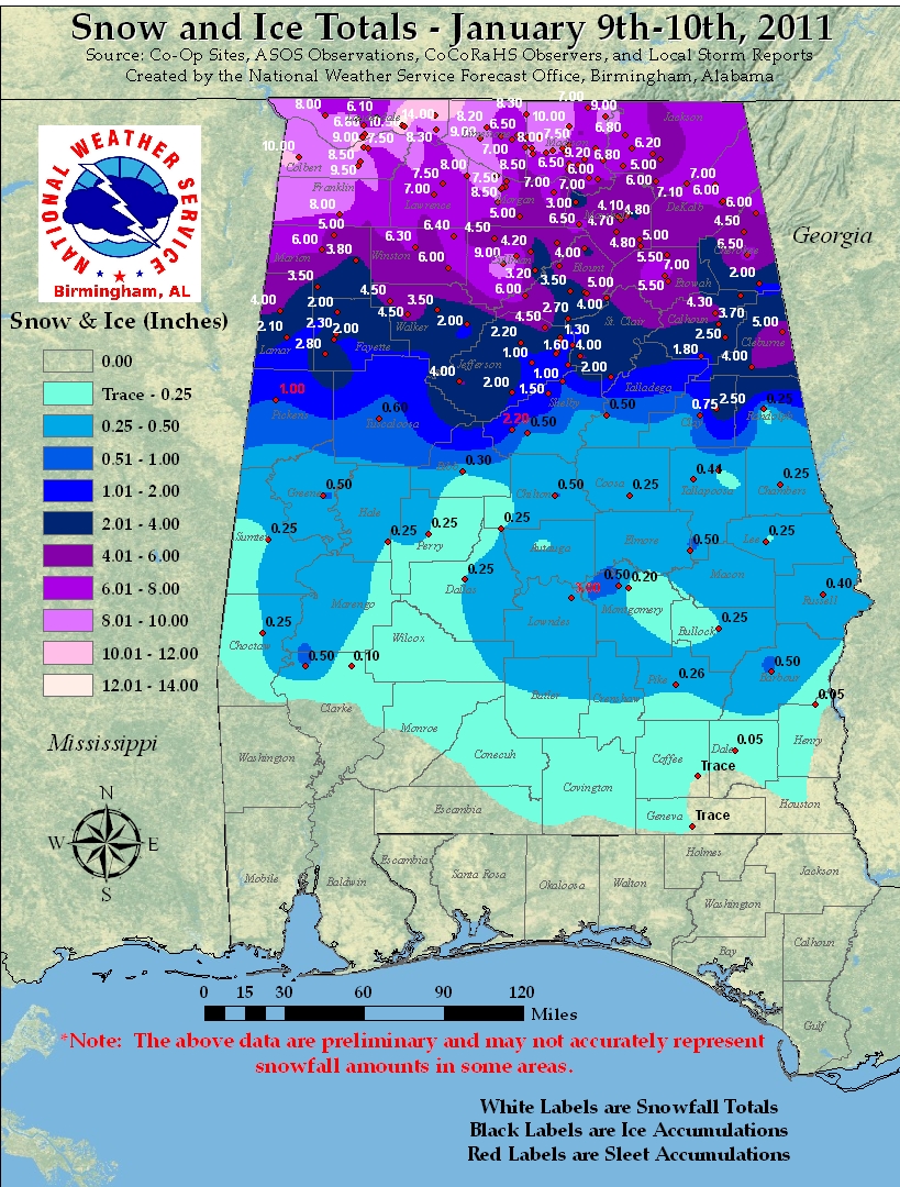
The ice and snow from Sunday night and Monday morning created havoc across most of the state. By Sunday evening, businesses and schools had already declared they would be closed on Monday and for good reason. Road conditions around central Alabama caused many counties to declare that roads would be closed overnight Sunday night. Unfortunately, this winter weather event caused the loss of at least 2 lives on area roadways because of slick conditions.
Though the majority of the activity was over by Monday night, the effects of the system were felt for the next couple of days. Areas that saw excessive amounts of snow were plagued with melting and refreezing on area roadways for the next couple of days, creating slick conditions through Wednesday, January 12th.
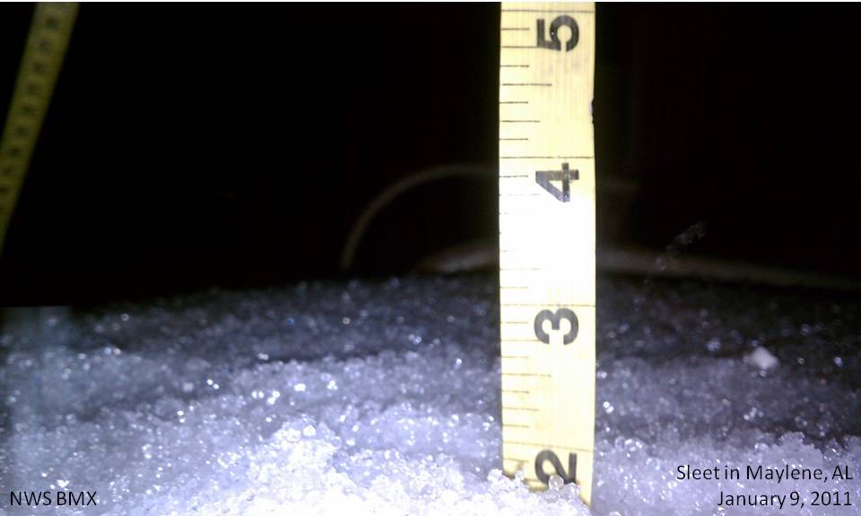
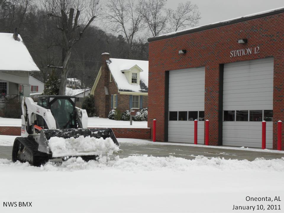
Sleet in Maylene, AL. Storm Totals of 2.5 inches. Snow in Oneonta, AL.
Submitted by Kristina Sumrall. Submitted by Blount County EMA.
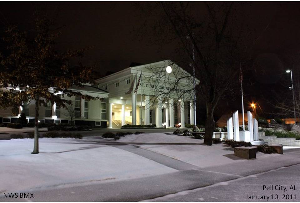
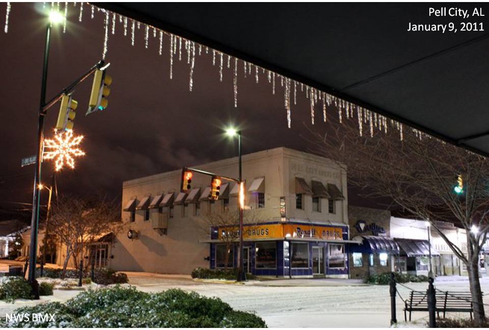
Snow at the courthouse in St. Clair County. Snow in downtown Pell City.
Submitted by Patrice Payne. Submitted by Patrice Payne.
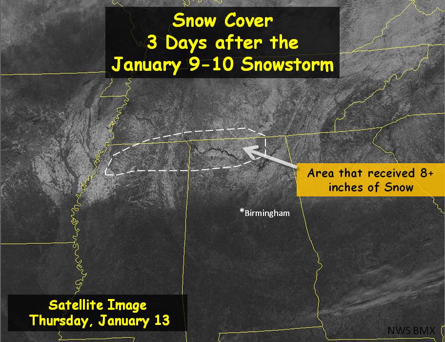
Visible Satellite Image of Snow 3 Days Later
If you have any pictures from this event you would like to share with us, please email them to [email protected]. Images can be submitted in any format, but please try to keep the file sizes below 500 Kb. Please include a date and location the image was taken, and a brief description. Although not every detail is needed, be as specific as you can. For proper credit for the image, also include your name and location.
ajr
Member
I know that as of recent, the MJO is much slower, and I'm far from an expert on tropical forcing, but these is the probabilities:
https://agupubs.onlinelibrary.wiley.com/doi/pdfdirect/10.1002/2016GL071423#:~:text=The climatological percentage probability for,predictions of a strong MJO.
Thanks! And sorry for the follow-on question here.. for the table from @Webberweather53, do you know if magnitude of the MJO is incorporated somehow? Looking at the forecast, I'm not sure how much the MJO is driving our pattern:
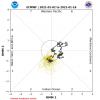
Climate Prediction Center - Daily MJO Indices
www.cpc.ncep.noaa.gov
Dewpoint Dan
Member
The Jan 11 snow is the only time ive ever seen patches of snow still on the ground a week later.
Local forecast by
"City, St" or ZIP code
Location Help
News Headlines
- 2020 Central Alabama Year in Review
- Weather History: Arctic Outbreak of January 6-7, 2014
- Weather Science Content for Kids & Teens!
- Get Ready for Winter Weather Hazards by Visiting Our Winter Safety Website!
- Follow Us on Social Media!
NWS Birmingham, Alabama
Weather Forecast Office
Heavy Snow & Ice Event - January 9-10, 2011
Weather.gov > NWS Birmingham, Alabama > Heavy Snow & Ice Event - January 9-10, 2011
Heavy Snow and Ice Event of January 9-10, 2011
- Current Hazards
- Current Conditions
- Radar
- Forecasts
- Rivers and Lakes
- Climate and Past Weather
- Local Programs
On the morning of Sunday, January 9th, a low pressure system formed in the Gulf of Mexico just off the Texas coast. This low pressure system traveled parallel to the Gulf Coast throughout the day on Sunday and into the day on Monday before moving over the Florida Panhandle and off the Atlantic Seaboard Monday night. Even though the system weakened as it moved eastward, it brought moisture across Central Alabama, where cold temperatures were already in place from a cold front that had moved through Friday and Saturday, the 7th and 8th of January.

Surface Analysis from 6 PM Sunday Surface Analysis from 12 AM Monday

Surface Analysis from 6 AM Monday Surface Analysis from 12 PM Monday
By noon on Sunday, weak reflectivities were already on the radar, though, it wasn't until about 2 PM that afternoon when Tuscaloosa began reporting unknown precipitation. The bulk of the activity started later that evening, but because of an elevated warm layer of air that moved inland as the low pressure system passed to the south of Alabama, the southern half of the county warning area didn't receive any snow -- just ice and sleet. By daybreak Monday morning, areas north of Interstate 20 were reporting anywhere from 1 to 14 inches of snow with the heaviest totals near the Alabama-Tennessee state line. Ice reports were as high as 0.50 inches in multiple counties south of Interstate 20.
- Local Storm Reports from the event.

The ice and snow from Sunday night and Monday morning created havoc across most of the state. By Sunday evening, businesses and schools had already declared they would be closed on Monday and for good reason. Road conditions around central Alabama caused many counties to declare that roads would be closed overnight Sunday night. Unfortunately, this winter weather event caused the loss of at least 2 lives on area roadways because of slick conditions.
Though the majority of the activity was over by Monday night, the effects of the system were felt for the next couple of days. Areas that saw excessive amounts of snow were plagued with melting and refreezing on area roadways for the next couple of days, creating slick conditions through Wednesday, January 12th.

Sleet in Maylene, AL. Storm Totals of 2.5 inches. Snow in Oneonta, AL.
Submitted by Kristina Sumrall. Submitted by Blount County EMA.

Snow at the courthouse in St. Clair County. Snow in downtown Pell City.
Submitted by Patrice Payne. Submitted by Patrice Payne.
Visible Satellite Image of Snow 3 Days Later
If you have any pictures from this event you would like to share with us, please email them to [email protected]. Images can be submitted in any format, but please try to keep the file sizes below 500 Kb. Please include a date and location the image was taken, and a brief description. Although not every detail is needed, be as specific as you can. For proper credit for the image, also include your name and location.
Follow us on Twitter
Follow us on Facebook
Follow us on YouTube
BMX RSS Feed
CURRENT HAZARDS
National Outlooks
Tropical
Local Storm Reports
Public Information Statement
Hazardous Weather Outlook
CURRENT CONDITIONS
Drought Monitor
Regional Highs/Lows/Rainfall
Regional Weather Roundup
Rivers and Lakes
FORECASTS
Fire Weather
Air Quality
Forecast Discussion
Graphical Forecasts
Aviation Weather
CLIMATE AND PAST WEATHER
Past Events
Storm Data
Tornado Database
Daily Rainfall Plots
Local Climate Data
WARNINGS AND OTHER PRODUCTS
Tornado Warnings
Severe Thunderstorm Warnings
Flash Flood Warnings
Winter Weather Warnings
Special Weather Statements
Non-Precipitation Warnings
Flood/River Flood Warnings
PRODUCTOS EN ESPAÑOL
Conciencia y Preparación
Previsión de 7 Días
WEATHER SAFETY
Severe Safety w/ ASL
NOAA Weather Radio
All-Hazards Awareness Booklet
Severe Weather Preparedness
Severe Safety Rules
Tornado Safety Rules
AWARENESS WEEKS
Winter Weather
Hurricane Preparedness
Summer Safety Campaign
Fall Severe Weather
Severe Weather
SPECIAL PROGRAMS
StormReady
Flood Ready
CoCoRaHS
Storm Spotters (SKYWARN)
LOCAL RESEARCH AND OUTREACH
Other Research
Local Geographic Information Systems (GIS) Data
Outreach Activities
Local Climatology
Outreach Materials
Winter Weather
ABOUT US
Office History
Our Office
Contact Us
EDUCATION
Microbursts
Flood Products Description
About Radar
Severe Weather Videos
Winter Products Description
US Dept of Commerce
National Oceanic and Atmospheric Administration
National Weather Service
NWS Birmingham, Alabama
465 Weathervane Road
Calera, AL 35040
205-664-3010
Comments? Questions? Please Contact Us.
Disclaimer
Information Quality
Help
Glossary
Privacy Policy
Freedom of Information Act (FOIA)
About Us
Career Opportunities
yeah that was amazing storm here ?
NoSnowATL
Member
Man, remember the days when cold air was in place 1st. ?
NBAcentel
Member
Same type of low pressure is popping up on models but the big difference is, we don’t have a big system bombing out towards our NE acting as confluence, looking at that, now it makes me want to sacrifice the first ULL and turn it into a slow moving NE bomb for our second one
NBAcentel
Member
This is something I’ve noticed for the last several weeks. The MJO has been very low amped for the most part and at times has been in COD. The last several winters you could look at the MJO and see it going very close to the outside of the charts.Thanks! And sorry for the follow-on question here.. for the table from @Webberweather53, do you know if magnitude of the MJO is incorporated somehow? Looking at the forecast, I'm not sure how much the MJO is driving our pattern:
View attachment 61886
Climate Prediction Center - Daily MJO Indices
www.cpc.ncep.noaa.gov
Just remember that RMM plots aren't necessarily very good to match up with composites and analogs, since in reality, the MJO is much more complex. I read a post over on 33andRain and saw this graphic that shows each phase's correlation to temperatures on the east coast. Notice that even though phase 4-5-6 are warm, it doesn't mean that much temperature-wise on the east coast, if I'm reading this right. Obviously, if it's even weaker it will mean less, vs staying in high amplitude MC for a month with a strong PV as we did in 2019-2020. That's why I wouldn't freak out about going into the MC in February because we still gain the benefits from the Strat warm and AAM.Thanks! And sorry for the follow-on question here.. for the table from @Webberweather53, do you know if magnitude of the MJO is incorporated somehow? Looking at the forecast, I'm not sure how much the MJO is driving our pattern:
View attachment 61886
Climate Prediction Center - Daily MJO Indices
www.cpc.ncep.noaa.gov

Look how far south that 540 line is. ?Man, remember the days when cold air was in place 1st. ?
NBAcentel
Member
NBAcentel
Member
Look how far south that 540 line is. ?
It’s bad, especially on our side of the pole. Do feel some correction will take place but wow.
NBAcentel
Member
I think I remember this quite well ... one of the very few times the sleet/snow line actually wavered in our favor (wake county specifically apex is where I was at) cold air was much stronger than anticipated and there for the rates of snow we had piled the snow up quickly .. if I am remembering correctly
North west trend can’t let us down now right??Imagine if we could phase this stuff in the NE much earlier, that would blow up a big, slow moving 50/50 low and bode well for our second system View attachment 61888
NBAcentel
Member
V16 is a NE NC special View attachment 61867
For me!! I win!! LOL
For NC as a whole, he is wrong.Your snowiest month of the year is February, according to BRad
November: 3% (17 total)
December: 18% (114 total)
January: 35% (221 total)
February: 29% (186 total)
March: 14% (70 total)
April: 1% (8 total)
Last edited by a moderator:
Is this events or total snow?For NC as a whole, he is wrong.
November: 3% (17 total)
December: 18% (114 total)
January: 35% (221 total)
February: 29% (186 total)
March: 14% (70 total)
April: 1% (8 total)
EventsIs this events or total snow?
Stormlover
Member
I got 10 1/2 inches in NW Madison County near Huntsville. One of the sweet spots ;-) Got 4 inches in 1 hour! It was paradise
Local forecast by
"City, St" or ZIP code
Location Help
News Headlines
- 2020 Central Alabama Year in Review
- Weather History: Arctic Outbreak of January 6-7, 2014
- Weather Science Content for Kids & Teens!
- Get Ready for Winter Weather Hazards by Visiting Our Winter Safety Website!
- Follow Us on Social Media!
NWS Birmingham, Alabama
Weather Forecast Office
Heavy Snow & Ice Event - January 9-10, 2011
Weather.gov > NWS Birmingham, Alabama > Heavy Snow & Ice Event - January 9-10, 2011
Heavy Snow and Ice Event of January 9-10, 2011
- Current Hazards
- Current Conditions
- Radar
- Forecasts
- Rivers and Lakes
- Climate and Past Weather
- Local Programs
On the morning of Sunday, January 9th, a low pressure system formed in the Gulf of Mexico just off the Texas coast. This low pressure system traveled parallel to the Gulf Coast throughout the day on Sunday and into the day on Monday before moving over the Florida Panhandle and off the Atlantic Seaboard Monday night. Even though the system weakened as it moved eastward, it brought moisture across Central Alabama, where cold temperatures were already in place from a cold front that had moved through Friday and Saturday, the 7th and 8th of January.

Surface Analysis from 6 PM Sunday Surface Analysis from 12 AM Monday

Surface Analysis from 6 AM Monday Surface Analysis from 12 PM Monday
By noon on Sunday, weak reflectivities were already on the radar, though, it wasn't until about 2 PM that afternoon when Tuscaloosa began reporting unknown precipitation. The bulk of the activity started later that evening, but because of an elevated warm layer of air that moved inland as the low pressure system passed to the south of Alabama, the southern half of the county warning area didn't receive any snow -- just ice and sleet. By daybreak Monday morning, areas north of Interstate 20 were reporting anywhere from 1 to 14 inches of snow with the heaviest totals near the Alabama-Tennessee state line. Ice reports were as high as 0.50 inches in multiple counties south of Interstate 20.
- Local Storm Reports from the event.

The ice and snow from Sunday night and Monday morning created havoc across most of the state. By Sunday evening, businesses and schools had already declared they would be closed on Monday and for good reason. Road conditions around central Alabama caused many counties to declare that roads would be closed overnight Sunday night. Unfortunately, this winter weather event caused the loss of at least 2 lives on area roadways because of slick conditions.
Though the majority of the activity was over by Monday night, the effects of the system were felt for the next couple of days. Areas that saw excessive amounts of snow were plagued with melting and refreezing on area roadways for the next couple of days, creating slick conditions through Wednesday, January 12th.

Sleet in Maylene, AL. Storm Totals of 2.5 inches. Snow in Oneonta, AL.
Submitted by Kristina Sumrall. Submitted by Blount County EMA.

Snow at the courthouse in St. Clair County. Snow in downtown Pell City.
Submitted by Patrice Payne. Submitted by Patrice Payne.
Visible Satellite Image of Snow 3 Days Later
If you have any pictures from this event you would like to share with us, please email them to [email protected]. Images can be submitted in any format, but please try to keep the file sizes below 500 Kb. Please include a date and location the image was taken, and a brief description. Although not every detail is needed, be as specific as you can. For proper credit for the image, also include your name and location.


