L
Logan Is An Idiot 02
Guest
Euro has been fairlyy dry the last couple of runs


ALL OPTIONS ON THE TABKE STILL ?


I don't find that pleasant. I'm rooting for snow for all the big cities.I hate to be a Debbie Downer here but this baby is headed North. Looks like Richmond and North, maybe even DC. One pleasant thought is if the location of the low is too close to the coast or even slightly inland, the "big cities like DC, NY, and Philly will change to rn/zr halfway through the storm


Damn I just look at that and hope there someway we can shift that monster south where it’s hammering NC/SC, we better hope for south trends with the H5 energyNo need to be all upset. The 6gfs looks a bit better and its still 5 days away
Damn I just look at that and hope there someway we can shift that monster south where it’s hammering NC/SC, we better hope for south trends with the H5 energy
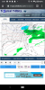
Someone’s getting a blizzard warning with this thing .. the way models have it combing out .. someone’s getting a crazy deform band
The really big fly in the ointment is that its too far north 5 days out. It's going to end up farther north or south than what's being shown currently. Hoping that it trends south is like hoping for the Braves to win the WS. It can happen, but....?I definitely believe Raleigh and places north and east from there can get in on the tip of the backend comma head as the system bombs out if the GFS is right. Its still the only model that really deepens the system that much.
That's good to hearThe good thing is that both the operational GFS and the CMC and their ensembles, keep bonafide cold air in north America from D10-D16. I can't see the EPS, but assuming that is the case, we wouldn't have to wait weeks for the next storm potential.
I need a NW trend in my neck of the woods! The cutoff from 12” to 2”, is razor thin, I’m looking at 2-4 from Monday’s storm, as of nowThe really big fly in the ointment is that its too far north 5 days out. It's going to end up farther north or south than what's being shown currently. Hoping that it trends south is like hoping for the Braves to win the WS. It can happen, but....?
Still time, though. As all of the energy/data gets well-sampled in the next day or two, we'll know by then.
The good thing is that both the operational GFS and the CMC and their ensembles, keep bonafide cold air in north America from D10-D16. I can't see the EPS, but assuming that is the case, we wouldn't have to wait weeks for the next storm potential.


I'll call that a win at this point. Interesting though because the EURO also shows quite a weak systemA less amped/flatter solution is definitely colder, need a shift south with the H5 wave View attachment 67222View attachment 67223
They run that long I guessLooks like those GFS runs yesterday for NC were a fluke. Why do we even bother looking at models past 5 days? It's useless.
How’s the Fv3 lookingThey run that long I guess
FV3 will get the hint eventually. Remember back in the day when it got that one storm right that one time? That was awesome.How’s the Fv3 looking


At least it's stopped the north trend for now, again different situation where things could easily come back south and would not take a huge shift.Notice how its improving because that feature in SE canada is moving in a better spot View attachment 67228
yeah were definitely not done with this system, a few more ticks of that TPV piece toward the GLs and more of NC is definitely in business, it would probably mean a flatter system as wellAt least it's stopped the north trend for now, again different situation where things could easily come back south and would not take a huge shift.