I love the 18z Euro!???Yea 18z EPS sucks, took a nod towards the GFS at H5, confluence is flying out the door
-
Hello, please take a minute to check out our awesome content, contributed by the wonderful members of our community. We hope you'll add your own thoughts and opinions by making a free account!
You are using an out of date browser. It may not display this or other websites correctly.
You should upgrade or use an alternative browser.
You should upgrade or use an alternative browser.
Pattern January 2021 - Joyless January
- Thread starter TheBatman
- Start date
NBAcentel
Member
ICON looks better, but not there yet


Webberweather53
Meteorologist
This run definitely looks worse at 500mb inside day 4. Those changes propagate forward in the run this thing will shoot even further north
NBAcentel
Member
At least better then 12z track wise, but yeah still not ideal at allThis run definitely looks worse at 500mb inside day 4. Those changes propagate forward in the run this thing will shoot even further north


Im sure by Wed or Thurs the new GFS will be back up and runing. What Karma it waits till now to shutdown.
Since its looking like that tpv vort is gonna be legit, show up in southern Canada. Im guessing we better start throwing our chips on it positioning 100 to 150 miles futher south over GL region. Webb has identified,explained well its influence pro&con.
Im weary to do this because on last nights 0z smash jobs ,it wasnt visible on the continental [NA] h5 maps. So we got real good confluence, HP strength position and struck Glory!
Ill say all models are stuborn today on it being there as well as its exact location. We cant afford for our ss vort to get out in front or its gonna get north on us. Walking a fine line/tango here and making it difficult to chose what feature we need to trend and how.
Webberweather53
Meteorologist
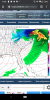
Well the SE US ridge is stronger in the short term even with a similar vort track it’s not something you wanna see because that means the mid level warm advection and boundary layer temps are starting out stronger and warmer respectively, making it harder for us to cash in even if the vort track is conducive.At least better then 12z track wise, but yeah still not ideal at all View attachment 67156View attachment 67157
NBAcentel
Member
Yeah the confluence is just hauling ass outa the NE/SE Canada as the system approaches
Man
Man
Our best option (IMO) is still for that piece of the vortex to never break off. 00z ICON tried to step back towards it not happening. It seems like such a razor thin margin between it happening or not, but once it's there, I'm not sure if there's going to be a way to work around it or not unless it can lift out of the way and allow the high to slide underneath it.

Webberweather53
Meteorologist
Yeah the big PV lobe there is the problem. Oth if it trends far enough to the southeast, gets out in front of our wave parks itself over the Great Lakes then we’ll have way more confluence than we had beforeYeah the confluence is just hauling ass outa the NE/SE Canada as the system approaches
Man View attachment 67158
Webberweather53
Meteorologist
This is what a stronger SE US ridge in the short term does to BL temps leading into the storm. Not doing ourselves any favors

I agree that would work, but there appears to be a lot of factors that are working to limit how far east it can go before the southern wave arrives. It's almost hard to know which to root for - the unlikely chance of it not breaking off at all, or the unlikely chance it can do as you said and get far enough east to enhance confluence.Yeah the big PV lobe there is the problem. Oth if it trends far enough to the southeast, gets out in front of our wave parks itself over the Great Lakes then we’ll have way more confluence than we had before
at least the ridge was a little taller behind the shortwaveYeah the big PV lobe there is the problem. Oth if it trends far enough to the southeast, gets out in front of our wave parks itself over the Great Lakes then we’ll have way more confluence than we had before

even if this thing were to go north like models have shown .. I think there will be a little deform band we would have to deal with .. who knows where it would set up but it could give people who get mostly rain some action
DC and Va dont need that storm on the icon. They've been through enough coming out of 2020. Need to be a good neighbor and take it off their hands.
The Pitt County ,Elizabeth City crowd has to be cringing looking at how razor thin a line this is to blasting our northern coastal plain. This thing bombs coming off the coast on every run. Rare chance where its not coming up from your south, hamering in WAA. Spring 1980 style
The Pitt County ,Elizabeth City crowd has to be cringing looking at how razor thin a line this is to blasting our northern coastal plain. This thing bombs coming off the coast on every run. Rare chance where its not coming up from your south, hamering in WAA. Spring 1980 style
Last edited:
Webberweather53
Meteorologist

NBAcentel
Member
SER flexing a bit more this run

NBAcentel
Member
Track is better 
lexxnchloe
Member
Much better.
NBAcentel
Member
Lol this is basically a warmer version of the early jan system (less confluence), and not cut off
But we’ve really loss the confluence
But we’ve really loss the confluence
Stormlover
Member
Euro control...had to find something pretty 
NBAcentel
Member
Maybe we could get this to severe weather haha 

What a wet the bed model.
LukeBarrette
im north of 90% of people on here so yeah
Meteorology Student
Member
2024 Supporter
2017-2023 Supporter
Just embarrassingMaybe we could get this to severe weather haha View attachment 67166View attachment 67167
lexxnchloe
Member
What happened?
The sad thing is that if that upper low doesn't break off, tonight's runs would be absolutely epic with the further south track of the shortwave. Instead, we are looking at rain in the upper 40s with once again, no parent high.Track is better View attachment 67163
Webberweather53
Meteorologist
El Nino!

NBAcentel
Member
No confluence/TPV piece in Canada not in a ideal spot basically means A ---- show ULL with heavy rain
L
Logan Is An Idiot 02
Guest
iGRXY
Member
I know we have at least another 2 days before we should throw this one away but since the 0z runs last night we have had worse and worse trends. We shouldn’t throw this one away yet but man it’s making it hard not to just move on from this.
What a monster
NBAcentel
Member
This hurts 

Tarheelwx
Member
V16 seems to be giving it a go?
TW
TW
Sheesh dc gets crushed
Wonder if the Maryland person who won 700 million the other night,likes snow. Ji probably won the 1 billion one tonight. Then flipped on his computer and saw the gfs.This hurts View attachment 67173
Blue_Ridge_Escarpment
Member
Not too shabby here

Webberweather53
Meteorologist
The problem we run into w/ a stronger upstream ridge is that the downstream trough, while it digs more to the south which is good, it gets super amped, strengthens the warm advection out ahead of it. Oth, of course gives us a bigger storm to work w/ in general. Really need the vort track to be down near I-20
We need about 1 or 2 more of these.

only about 60 miles from Metwannabe house to see shin deep snow. Epic face slap