*starts to drool like a Pavlov dog at any mention of Jan 2011..
-
Hello, please take a minute to check out our awesome content, contributed by the wonderful members of our community. We hope you'll add your own thoughts and opinions by making a free account!
You are using an out of date browser. It may not display this or other websites correctly.
You should upgrade or use an alternative browser.
You should upgrade or use an alternative browser.
Pattern January 2021 - Joyless January
- Thread starter TheBatman
- Start date
Webberweather53
Meteorologist
88’ was a +
88 was a + NAO, overrunning event? I thought?
Jan 88 had neutral AO, positive NAO, slightly positive PNA, strong +WPO, big -EPO went up around New Years 1988 and lingered into the 2nd week of the month.
NBAcentel
Member
Super fast gif so I could actually post it here but wow, lol southeast ridge has been bullied this winter by the -NAO 
cd2play
Member
Looks good for CAD areas; TN not so much
I actually remember Walter Cronkite talk about the “Siberian Express” coming our way before the 88 storm hit. That -EPO was really doing the work then. Lol, I’m showing my age.Jan 88 had neutral AO, positive NAO, slightly positive PNA, strong +WPO, big -EPO went up around New Years 1988 and lingered into the 2nd week of the month.
Wow.. say hello to Mega Rainstorm Southeast Style: 
Even Wilkes can't manage onset ice.Wow.. say hello to Mega Rainstorm Southeast Style: View attachment 65035
NBAcentel
Member
I wonder if he’s ever coming back lolEven Wilkes can't manage onset ice.
D
Deleted member 609
Guest
he'll make his own iceEven Wilkes can't manage onset ice.


Webberweather53
Meteorologist
GEFS has a -WPO towards the end with a strange upper air pattern View attachment 65001View attachment 65002View attachment 65003
GFS......View attachment 65004have we seen something like that look before ?
A number of 12z EPS members are taking the WPO down thru the floor after Jan 21st.
NBAcentel
Member
Well for the folks that screamed “fix the pacific”, there you go, lolA number of 12z EPS members are taking the WPO down thru the floor after Jan 21st.
View attachment 65042
Avalanche
Member
I was listening to Bob Debarbaladen (WRAL) at the time.I actually remember Walter Cronkite talk about the “Siberian Express” coming our way before the 88 storm hit. That -EPO was really doing the work then. Lol, I’m showing my age.
Avalanche
Member
Where's the High??? 

NBAcentel
Member


Avalanche
Member
LOL, everywhere but where I want it.
Webberweather53
Meteorologist
LOL, everywhere but where I want it.
You do realize that this is a long range ensemble mean and will be predisposed to look like this anyway right?
NBAcentel
Member
For that far out I wouldn’t worry at all, finally a feed of HP out of CanadaLOL, everywhere but where I want it.
Avalanche
Member
Yes. LOLYou do realize that this is a long range ensemble mean and will be predisposed to look like this anyway right?
Webberweather53
Meteorologist
Yes. LOL
Well... no. You definitely should not be worried about sfc high locations on a 10-15 day ensemble mean.
Why?
Ensemble means this far in advance smooth out individual waves and cold sfc highs that descend into the CONUS during that period, the sfc highs won't be quasi-stationary over the Canadian Rockies as the ensemble mean shows due to mixing by transient waves in the mean flow.
I see they rebooted the commodore 64 the GFS runs on and it finally finished. Pretty wild seeing it so close to the EPS.
View attachment 65043
I really like seeing that massive PV lobe being squashed over Siberia.
Webberweather53
Meteorologist
We're likely headed towards the day +20 - +40 composite pattern in late Jan/early Feb. Once high-latitude N Pacific goes up, they'll initially be a transient SE ridge w/ a cold dump from the Arctic & Siberia into the Canadian Rockies ~Jan 20th, followed by massive shots of arctic air into the CONUS thereafter w/ said pattern probably lingering into at least the beginning of February.
That's actually textbook where we want the high for Miller A events thanks to @Webberweather53's chart.LOL, everywhere but where I want it.
Snow and cold are entirely possible as long as we aren't getting low pressure to flood into the CONUS.

accu35
Member

Webberweather53
Meteorologist
Last time we saw a -PNA/-NAO pattern like what's being modeled in late January was Mar 2018.

Could you imagine doing this pattern again a month earlier in the calendar year when there's actually legit cold air to work w/? 3 accumulating snows in less than 2 weeks in mid-late March for the I-40/85 corridor is pretty darn impressive, wonder what that would translate to if it was late Jan/early February instead.


Could you imagine doing this pattern again a month earlier in the calendar year when there's actually legit cold air to work w/? 3 accumulating snows in less than 2 weeks in mid-late March for the I-40/85 corridor is pretty darn impressive, wonder what that would translate to if it was late Jan/early February instead.
Stormlover
Member

ATLwxfan
Member
Blocking of the jet stream related to Sudden Stratospheric Warming event and -AO/NAO underway
Major long-lasting record cold coming to Georgia soon? NOPE.
 www.wsbradio.com
Sent from my iPhone using Tapatalk
Last time we saw a -PNA/-NAO pattern like what's being modeled in late January was Mar 2018.
View attachment 65047
Could you imagine doing this pattern again a month earlier in the calendar year when there's actually legit cold air to work w/? 3 accumulating snows in less than 2 weeks in mid-late March for the I-40/85 corridor is pretty darn impressive, wonder what that would translate to if it was late Jan/early February instead.
View attachment 65048
View attachment 65049
View attachment 65050
View attachment 65051
I can’t find great maps, but 2/25/15 maybe close as well?
Webberweather53
Meteorologist
The extended GEFS & Euro weeklies keep kicking the can down the road on when the -PNA tries to completely take over the pattern.
A few days ago, the GEFS showed the pattern going to -PNA dominated garbage by Jan 31. It took yesterday's run 4 days longer to get to that look due to a stronger -NAO near initialization and in the medium range dampening the SE ridge. I expect that trend to probably continue.


A few days ago, the GEFS showed the pattern going to -PNA dominated garbage by Jan 31. It took yesterday's run 4 days longer to get to that look due to a stronger -NAO near initialization and in the medium range dampening the SE ridge. I expect that trend to probably continue.
Dewpoint Dan
Member
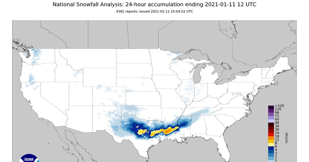
Webber, is this map showing 12-18" for Central Louisiana accurate ?
Webberweather53
Meteorologist
I can’t find great maps, but 2/25/15 maybe close as well?
Feb 24-25 2015 looks nothing like the pattern we're going into

Webberweather53
Meteorologist
Webber, is this map showing 12-18" for Central Louisiana accurate ?View attachment 65058
No, the totals in this area were on the order of 4-6" at most.
NOHRSC is okay for large-scale analysis of snowfall but it can be pretty bad for individual storms and in localized areas. It's one of the many reasons I currently manually make every one of maps by hand to ensure quality above all else.

See: https://www.weather.gov/source/crh/snowmap.html?zoom=8&lat=39.19&lon=-83.59&hr=48
The PNA going negative still scares me. The AO and NAO at least stay negative. And as Webber has pointed out, we can score without a positive PNA (..maybe with better odds). But man oh man:

Bannerdude
Member
Wife texted that it was briefly sleeting in Durham a few minutes ago. Another tally for a winter weather microevent. /s
NBAcentel
Member
If we could shift that trough south, then stuff could maybe break containment and we get another flizzard 

Gotcha, I could only find basic US charts in the time I had.
Webberweather53
Meteorologist
The only thing we are losing with a -PNA is the threat of Miller A cyclones. If a winter storm shows up with the -PNA in place, we’re much more likely gonna get overrunning or Miller B. Could also see a sneaky clipper or two in this pattern as wellThe PNA going negative still scares me. The AO and NAO at least stay negative. And as Webber has pointed out, we can score without a positive PNA (..maybe with better odds). But man oh man:
View attachment 65061
NBAcentel
Member
??


NBAcentel
Member
RIP southern slider system, maybe it’ll come back, lol 
