Appreciate Webb adding the 1.22.2011 event with context, I was eating Mexican ivo Greenville with a couple on this board, as well as playing poker afterwards while MHX got crushed.
-
Hello, please take a minute to check out our awesome content, contributed by the wonderful members of our community. We hope you'll add your own thoughts and opinions by making a free account!
You are using an out of date browser. It may not display this or other websites correctly.
You should upgrade or use an alternative browser.
You should upgrade or use an alternative browser.
Pattern January 2020 - Operation Thaw Alaska
- Thread starter KyloG
- Start date
Jon
Member
View attachment 31439
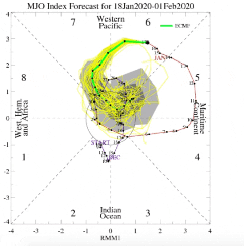
The JMA’s MJO forecast has kind of been out to lunch lately and is way too amped in the central pacific and thus it takes longer for the wave to attenuate, which is why it’s showing phase 8 propagation. While I don’t think this scenario is impossible, given the forecast initialization errors and that this winter has been marred by strong/persistent +EPO (that the GEFS & EPS forecast) and that both the GEFS & ECMWF depict degeneration into phase 7, I’m skeptical of the nice -EPO JMA forecast in week 2. When the GEFS & ECMWF MJO forecasts agree (which doesn’t happen often), they’re usually correct. From multiple standpoints I’m cautious to buy into the JMA in spite of its recent string of forecast verification
I do recall the JMA being way off in December with its amplitude but it still nailed the 500mb forecasts for Week 2. It kept wanting to spike the amplitude like the forecast above (and I mean spike it to the extreme in one day lead) when you obviously knew by looking that it was incorrect. Interesting to see if it busts hard here...still taking it with a mound of salt.
Sent from my iPhone using Tapatalk
baroowoofr
Member
That would explain why the JMA ensembles looks like the CFS then. Both are alone in the MJO progression right now on their RMMs.
I'll throw this out there as a possible learning experience for me. I posted the following a little earlier at AmWx but would appreciate Webb's and any others' input:
What is the Euro seeing?
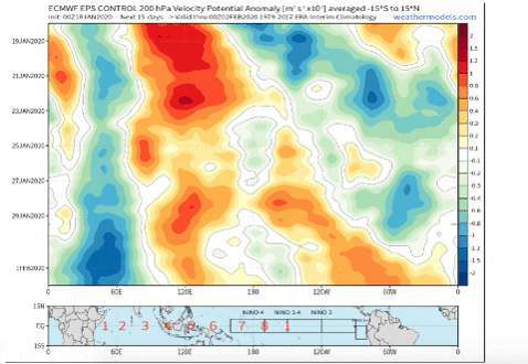
(I know its only the control, but that's the closest access I have to the OP)
Looking at that, I'm not really sure what the Euro sees to send it back to 5/6. Looks to me like it still favors 1/2
I know OLR isn't the only thing that goes into the MJO RMM plot calculation, but you'd think it would show more convection over the MC for that RMM plot.
Indian Ocean though:
Some of it there even looks like to would be N of the equator late in the run.
Are the RMM plots calculated through some measurement that would split the difference between two convection locations?
Isotherm was arguing that most of it was south of the equator, and not having a substantial impact
(I think the +AAM from the W Pac convection would argue otherwise).
But a lot of that Indian Ocean convection looks south to me.
I'll throw this out there as a possible learning experience for me. I posted the following a little earlier at AmWx but would appreciate Webb's and any others' input:
What is the Euro seeing?
(I know its only the control, but that's the closest access I have to the OP)
Looking at that, I'm not really sure what the Euro sees to send it back to 5/6. Looks to me like it still favors 1/2
I know OLR isn't the only thing that goes into the MJO RMM plot calculation, but you'd think it would show more convection over the MC for that RMM plot.
Indian Ocean though:
Some of it there even looks like to would be N of the equator late in the run.
Are the RMM plots calculated through some measurement that would split the difference between two convection locations?
Isotherm was arguing that most of it was south of the equator, and not having a substantial impact
(I think the +AAM from the W Pac convection would argue otherwise).
But a lot of that Indian Ocean convection looks south to me.
I do recall the JMA being way off in December with its amplitude but it still nailed the 500mb forecasts for Week 2. It kept wanting to spike the amplitude like the forecast above (and I mean spike it to the extreme in one day lead) when you obviously knew by looking that it was incorrect. Interesting to see if it busts hard here...still taking it with a mound of salt.
Sent from my iPhone using Tapatalk
Hopefully you're onto something and nice analysis, but my experience with the JMA operational is that it generally sucks (perhaps not as bad as NAM/NAVGEM) and that the GFS and ICON are better. Even the CMC may be better. The Euro is way better. With a sucky underlying operational, I'd expect the ensemble to be sucky, too, unless the ensemble is somehow based on a newer, improved underlying JMA (doubtful since I'd think that new and improved underlying JMA would be the new operational).
Meanwhile, crickets at Weather Bell with still no JB Saturday Summary. Last week's, which emphasized that winter was getting started 1/20 and that cold would dominate then through March, is still there. I wonder why:
https://www.weatherbell.com/
Last edited:
Not sure If anybody has posted this, but here is the CPC 3/4 week forecast (credit to Grayman from the other board):
https://www.cpc.ncep.noaa.gov/products/predictions/WK34/
https://www.cpc.ncep.noaa.gov/products/predictions/WK34/
Stormlover
Member
I posted it a day or two ago http://southernwx.com/community/threads/january-2020-operation-thaw-alaska.663/page-122Not sure If anybody has posted this, but here is the CPC 3/4 week forecast (credit to Grayman from the other board):
https://www.cpc.ncep.noaa.gov/products/predictions/WK34/
Last edited:
L
Logan Is An Idiot 01
Guest
So you'll take garbage modelsView attachment 31439
The JMA’s MJO forecast has kind of been out to lunch lately and is way too amped in the central pacific and thus it takes longer for the wave to attenuate, which is why it’s showing phase 8 propagation. While I don’t think this scenario is impossible, given the forecast initialization errors and that this winter has been marred by strong/persistent +EPO (that the GEFS & EPS forecast) and that both the GEFS & ECMWF depict degeneration into phase 7, I’m skeptical of the nice -EPO JMA forecast in week 2. When the GEFS & ECMWF MJO forecasts agree (which doesn’t happen often), they’re usually correct. From multiple standpoints I’m cautious to buy into the JMA in spite of its recent string of forecast verification
Mind showing18Z Euro joins the GFS, ICON, and the NAM as looking a bit better than the 12Z. Hmmm.
Webberweather53
Meteorologist
So you'll take garbage models
Mind showing
Are you actually going to post something worthwhile today or continue incessantly trolling & posting mindless bullcrap?
18Z Euro joins the GFS, ICON, and the NAM as looking a bit better than the 12Z. Hmmm.
My 2nd GIF thanks to Webb: 12Z worse than 0Z but 18Z better than 12Z and looks even better than 0Z imo as there is lower pressure further west on the 18Z..so keeping the 10% chance in my mind

pcbjr
Member
Webb - Ignore - You have far better things to toss energy at!Are you actually going to post something worthwhile today or continue incessantly trolling & posting mindless bullcrap?
Best,
Phil
For the 1/22 period, northern stream dominant vortmax will likely be through central MO, coastal areas need central KS as a baseline.
Last edited:
What?So you'll take garbage models
Mind showing
L
Logan Is An Idiot 01
Guest
That was not meant for Eric. I was asking someone to show the 18z EUROWhat?
Cad Wedge NC
Member
Dude, you need to chill out. Your trolling is getting old real fast. That's a good way to get a "time-out".So you'll take garbage models
Mind showing
pcbjr
Member
Like!Dude, you need to chill out. Your trolling is getting old real fast. That's a good way to get a "time-out".
To add: God does not live on this Board, so this place does not make the weather, and our only LMHC is a mod who doesn't get paid to counsel disgruntled posters ...
For the 1/22 period, northern stream dominant vortmax will likely be through central MO, coastal areas need central KS as a baseline.
I agree that It very likely won't happen, but only 100 miles separates much of the SE coast from the edge of the significant precip. on the 18Z runs and there's still ~60-72+ hours to go. What if upper features end up being 100 miles west of what the Euro and Icon have and the resultant sfc low is 100 miles further west? I realize that a further westward trend would need to get going almost immediately though.
I know it is a horrible model, but since it is agreeing with the trend of the other 18Z model runs: the 18Z NAVGEM also has a low center further west and stronger than what its 12Z had:
NAVGEM 18Z run:

NAVGEM 12Z run:

NAVGEM 18Z run from 24 hours ago

accu35
Member
Pivotal euro doesn't have 18z. Do you have 18z euro snow map for that light clipper?My 2nd GIF thanks to Webb: 12Z worse than 0Z but 18Z better than 12Z and looks even better than 0Z imo as there is lower pressure further west on the 18Z..so keeping the 10% chance in my mind
View attachment 31441
Shaggy
Member
I agree that It very likely won't happen, but only 100 miles separates much of the SE coast from the edge of the significant precip. on the 18Z runs and there's still ~60-72+ hours to go. What if upper features end up being 100 miles west of what the Euro and Icon have and the resultant sfc low is 100 miles further west? I realize that a further westward trend would need to get going almost immediately though.
I know it is a horrible model, but since it is agreeing with the trend of the other 18Z model runs: the 18Z NAVGEM also has a low center further west and stronger than what its 12Z had:
NAVGEM 18Z run:
NAVGEM 12Z run:
NAVGEM 18Z run from 24 hours ago
There is zero reason to think this is suddenly going to shift into something good for us. The trough is just not showing too many signs of going nuetral or negative in time.
At the same time if I was bullseyed at 60-72 hours left to go it would certainly change that's 100% guaranteed. It doesnt mean this is gonna change in any kind of favorable way but that changes could still show up.

NAM increased the RH as well this run
Jon
Member
Amazing trend last 4 runs, unfortunate it won’t matter...

Sent from my iPhone using Tapatalk

Sent from my iPhone using Tapatalk
accu35
Member
College Dupage has a better map, I've been watching this closely. Nothing big, but gefs does show a few members with this look. I believe frozen onset isn't out of the question.

The 0Z GFS/GEFS trended slightly further offshore vs the 18Z. However, the 0Z CMC joins the group in having a stronger low and further west in response to the upper level energy going offshore:
0Z CMC

0Z CMC 500 mb:

12Z CMC 500 mb:

Up next, the very crucial Doc. If Doc is not any better than the 18Z or if it is worse, I’d likely reduce the chance further. But if it is better, I’d either keep the 10% chance or even increase it.
0Z CMC
0Z CMC 500 mb:
12Z CMC 500 mb:
Up next, the very crucial Doc. If Doc is not any better than the 18Z or if it is worse, I’d likely reduce the chance further. But if it is better, I’d either keep the 10% chance or even increase it.
Last edited:
The 0Z Good Doctor says "no" as it is a bit worse than 18Z and back toward the 12Z though not all the way there. As a result, I'm reducing the chance for precip to get back to the coast to a significant degree from 10% to 5%. Next up: 6Z models. Night night!
Last edited:
Stormsfury
Member
Well, the upper feature has CHS taking note
It is interesting that a clipper-like system is expected to quickly
ripple over the region on Tuesday, slowly closing off at H5. As the
system passes over the CWA, H85 temperatures cool to -6 to -9C.
Using a blend of MOS, highs on Tuesday are expected to remain 10-13
degrees below normal. The core of the mid and high level moisture is
expected to pass to the south, however, cloud cover is expected to
increase through the daylight hours on Tuesday. By late Tuesday, the
mid-level disturbance will pass over the cold front over the western
Atlantic, resulting in cyclogenesis east of the Gulf Stream. As a
result, a few showers are forecast to develop across the outer GA
waters, temperatures in the upper 40s to low 50s should support all
liquid.
Webberweather53
Meteorologist
I have to admit, this pattern is actually serviceable.
If we make a few minor adjustments to the strength/depth of the Atlantic Canada trough and are somehow able to nudge the Hudson Bay ridge a smidge further north, and push this SW US trough & west coast ridge a little eastward we might have just enough to sneak a storm in. Obviously cold air will be lacking in general here because we have a +EPO/+NAO, but a deep enough Newfoundland trough (50/50 low) can provide us just enough at least if you're near the I-40 corridor in CAD favored areas.
.png")
If we make a few minor adjustments to the strength/depth of the Atlantic Canada trough and are somehow able to nudge the Hudson Bay ridge a smidge further north, and push this SW US trough & west coast ridge a little eastward we might have just enough to sneak a storm in. Obviously cold air will be lacking in general here because we have a +EPO/+NAO, but a deep enough Newfoundland trough (50/50 low) can provide us just enough at least if you're near the I-40 corridor in CAD favored areas.
Webberweather53
Meteorologist
Deeper Atlantic Canada trough ~ day 10-11 and a properly timed southern stream wave....

Forevertothee
Member
ForsythSnow
Moderator
EPS doesn't look that bad from overnight. Looks to me that the LR trends are cooling and the once-torch is now starting to be replaced with a trough. Despite it being a bit east, it's decided to show up again and almost looks to be a split flow developing at the end as opposed to a -PNA.
EPS doesn't look that bad from overnight. Looks to me that the LR trends are cooling and the once-torch is now starting to be replaced with a trough. Despite it being a bit east, it's decided to show up again and almost looks to be a split flow developing at the end as opposed to a -PNA.
Yeah, the 0Z EPS is only about 3 AN for days 6-15 averaged out vs the prior run of 5 AN. However, even the EPS has been cold biased of late (all models have been though the GEPS followed by GEFS have been the worst). So, it wouldn’t at all surprise me if it ends up being at +5 or warmer, especially considering the forecasted MJO as well as the AO/NAO indicating a continued lack of high latitude blocking.
Other than short cold periods like the one about to start, I’m leaning to no sustained cold until at least late Feb as of now. Hopefully that’s wrong but I see no reason to bet against it right now.
In the meantime, enjoy the cold of the next few days!
Last edited:
ForsythSnow
Moderator
I think it would be a good idea not to take the MJO forecast at face value other than for the next few days and wait and see. Last time we went around we ended up further to the left than expected, and for a range like that, it's really unpredictable especially as we dive into the COD.Yeah, the 0Z EPS is only about 3 AN for days 6-15 averaged out vs the prior run of 5 AN. However, even the EPS has been cold biased of late (all models have been though the GEPS followed by GEFS have been the worst). So, it wouldn’t at all surprise me if it ends up being at +5 or warmer, especially considering the forecasted MJO and AO/NAO indicating a continued lack of high latitude blocking.
Other than short cold periods like the one about to start, I’m leaning to no sustained cold until at least late Feb as of now. Hopefully that’s wrong but I see no reason to bet against it right now.
Though coming down from extremely high levels, the GEFS AO forecast still is ugly and the GEFS has been underforecasting the AO by an average of 0.5 in the longer range. In addition, the NAO forecast is still positive. Combine all of that with an uninspiring for cold MJO forecast tells me the trend is my friend and that solidly AN averaged out over the next 4 weeks is the pattern to bet on though hopefully not anything like the torch we’ve had the prior 4 weeks. The good news is that history says a cold late Feb into March is quite doable, if not somewhat probable:


Fwiw and not much I know, but the 3k NAM has the slp closer to the upper energy and closest to the coast. Verbatim you would think the precip shield would be a little more expansive to the NW, at least getting some to the coast. It's a long shot but I wouldn't discount the beaches seeing something fall just yet

Sent from my SM-G950U using Tapatalk

Sent from my SM-G950U using Tapatalk
Blue_Ridge_Escarpment
Member
Currently just south of Myrtle for the weekend and yesterday was wonderful here, sunny mid 60s. Today it’s overcast and mid 60s already. Supposed to be around 30 tonight, big changes coming.Fwiw and not much I know, but the 3k NAM has the slp closer to the upper energy and closest to the coast. Verbatim you would think the precip shield would be a little more expansive to the NW, at least getting some to the coast. It's a long shot but I wouldn't discount the beaches seeing something fall just yet
Sent from my SM-G950U using Tapatalk
Fwiw and not much I know, but the 3k NAM has the slp closer to the upper energy and closest to the coast. Verbatim you would think the precip shield would be a little more expansive to the NW, at least getting some to the coast. It's a long shot but I wouldn't discount the beaches seeing something fall just yet
Sent from my SM-G950U using Tapatalk
The new ICON is better as it actually has light snow near the coast in the Wilmington area (look closely for the small light blue area):

Now take the slp location of the 3K NAM with the NW expansion of precip from the slp of the ICON and you got something lolThe new ICON is better as it actually has light snow near the coast in the Wilmington area (look closely for the small light blue area):View attachment 31460
Sent from my SM-G950U using Tapatalk
Shaggy
Member
Now take the slp location of the 3K NAM with the NW expansion of precip from the slp of the ICON and you got something lol
Sent from my SM-G950U using Tapatalk
I told myself I'd watch it till 12z tomorrow. Like I told rain cold, if I was expecting a foot it would definitely change in the short range. If I was I-17 or east I would be more interested but things still have time to make enough changes for coast to see some snow showers.