baroowoofr
Member
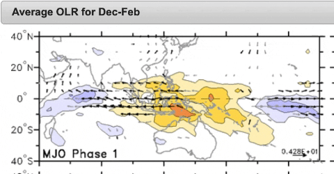
Current convection doesn't look too far off from the Australian Board of Meteorology's version of MJO phase 1
The 18Z EPS is continuing a general trend of inching toward the coast and is actually kissing parts of the NC coast with light precip. In the Wilmington coastal area, it has it starting around Tue at sunset and continuing though much of Tue night. Most or all of this would be snow from all indications. Keep watching it, especially coastal folks, as this is still not a done deal/48 hours away and moderate precip is only ~30 miles offshore/heavy only 75 miles offshore!
View attachment 31493
I think my area around Tuscaloosa maybe a little to far south but if I see snowflakes I will take itPer Euro, yes especially N half of AL has a chance during a portion of tomorrow and tom night (may be two waves of it)! Euro has patches of light snow, flurries, etc. Enjoy it!
and if you were to get under one of those it can pile up in a hurry... February 2013 is great example of that in CLT. A line of thunderstorms with heavy snow came through and put down 2-3 inches in a little over an hour throughout the metro areaOne thing I note right now is how steep the low level lapse rates are going to be with this ULL. Any mode of insolation could fire up CU towers capable of quick bursts of precip...much like the summer does with afternoon convection.


Nice walking wx here this evening of 49 and a decent breeze.
Meanwhile, the 0Z NAM keeps the precip well offshore. If the 0Z consensus doesn’t come in any closer, especially the Euro and ICON, it may then be time to bring the chance of sig precip making it back to the coast to under 5%.

I can’t believe I’m posting this. Lmao HR36 HRRR says well.....this.....
Is this realistic? Seems a bit off from everything else but looks nice.I can’t believe I’m posting this. Lmao HR36 HRRR says well.....this.....
View attachment 31495View attachment 31496View attachment 31497View attachment 31498
Do you want to be directly under this closed contour as it passes overhead? or is there more to it than that?I wouldn't be surprised if some isolated areas of N GA get some flurries as the upper level trough swings over. It'll probably attempt to wring out as much moisture as it possibly can. Even on the recent NAM/GFS, it shows isolated pockets of moisture in the mid levels.

Do you want to be directly under this closed contour as it passes overhead? or is there more to it than that?
Well I have been noticing (for GA) there is a nice easterly or NE flow that sets up from the SFC to about 800MB. That is providing higher RH levels. (Increasing on models as well). There will be plenty of lift as well with that strong shortwave/ULL. To be honest, I’m still a little bit surprised there isn’t more showing up like the HRRR. We shall see. Euro sorta sees it.
The little moisture available comes between hours 30-36. The moisture is definitely under the 500 mb closed contour.
It's really dry at the 925mb height. Whatever might fall would probably dry up before it reached the surface even if the midlevels were moist enough. Light flurries is probably the best anyone should expect, if anything at all really.


It’s not really a snowstorm pattern to say the least but it’s not a torch pattern either. In the past I would have rather liked the 60-70F’s if it wasn’t going to snow but now I will happily take any seasonal temps we can get. The 60-70F’s probably aren’t to far away though.
View attachment 31502View attachment 31503
Yep several snow reports in/around the Nashville area.Flurries in parts of tenn this morning
Sent from my iPhone using Tapatalk

That's impressively consistent maybe I can hold off on the pre emergentIt’s not really a snowstorm pattern to say the least but it’s not a torch pattern either. In the past I would have rather liked the 60-70F’s if it wasn’t going to snow but now I will happily take any seasonal temps we can get. The 60-70F’s probably aren’t to far away though.
View attachment 31502View attachment 31503
One thing I note right now is how steep the low level lapse rates are going to be with this ULL. Any mode of insolation could fire up CU towers capable of quick bursts of precip...much like the summer does with afternoon convection.
If they're getting flurries now and if those make it down here later tonight, I wonder if the HRRR will be right and give us a few hours of light snow here tomorrow morning.Even w/ lackluster radar returns and anemic snow growth in the DGZ, light snow is falling across a large portion of the Tennessee & Ohio Valley. Keep an eye to the sky today, radar is almost certainly going to overshoot the low-level stratus deck that's generating the snow down to northern Alabama this morning. Certainly could see a few snow flurries making it down to the Atlanta area later.
View attachment 31511
If they're getting flurries now and if those make it down here later tonight, I wonder if the HRRR will be right and give us a few hours of light snow here tomorrow morning.
Marion? There was no snow that I seen.Getting reports back home of a nice coating of snow this morning. Temps around 16 there. Pretty chilly here on the Grand Strand this morning as well, bottomed out at 30 before a beautiful sunrise.
The NC Mtns are Looking real good for a big upslope event Next Sun/Mon. Talking 4-12 inch type deal, depending on elevation , especially northern mtns.
Up in the cove near BaxterMarion? There was no snow that I seen.