RollTide18
Member
Trying to remember the last time there have been this much support for the Deep South, at least this far out.
This post clearly shows you have absolutely no idea what you're talking about (as usual). Declaring winter is over as you've prematurely done more than once here the last few weeks means there's absolutely no chance of it coming back and we immediately move onto spring, there's a big discrepancy between saying that and winter is taking a break. Seems pretty obvious here you don't understand the difference between the two.
"As I see it as of now, just some cold shots with some minor frozen precipitation outside of the mountains through late month into early February"
This is based on what exactly? You're speaking in absolutes and already talking about specifics wrt who will get snow & who won't, roughly how intense those cold shots & storms will be for a mediocre pattern that probably won't verify a few weeks to a month from now. This is a good way to have egg on your face, as you've probably experienced several times this winter when you were making winter storm threat maps for a storm that was over a week away & don't be shocked if everyone laughs at you in a couple weeks for declaring winter was over last week.
You've overcorrected for your far too overzealous mannerism, you need to find the happy medium/middle ground and learn to not speak in absolutes or discuss ANY specifics in a pattern more than a week or two in advance as you've done here, let alone make winter storm maps for events that over 6-7 days away. That is just as bad as someone declaring winter is over or that we're going to have a "pants exploding" winter storm based on a singular 300+ hour operational model run.
I do like how the ensembles are progressing, but it is a little troubling that neither the GFS or the Euro Ops are all that cold. I realize the pattern really isn't getting going till around D10 or after, but you'd think we'll have to start seeing some consistency in the operationals sooner or later.
Well anyone have the 12z Euro run? Just curious on what it had to say...


View attachment 30350
This looks interesting. I don’t know if anyone else has precip maps.


That is last nights runProbably not going to happen, but close.


Sent from my iPhone using Tapatalk
That is last nights run


Do you have 216?Duh. Second time that’s happened today. Here are correct maps. We just need a stronger Shortwave in the SW.


Sent from my iPhone using Tapatalk
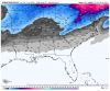
Eastern NC/SC ended up having a good snowstorm on 1/3 or 1/4/2018... Charleston has 5 or 6 inchesFound it in an old text! Did NC or anyone get anything during this period? If so than this time could be different if the mean I posted included a storm that actually happened in the short term and this mean includes that. View attachment 30340
Found it in an old text! Did NC or anyone get anything during this period? If so than this time could be different if the mean I posted included a storm that actually happened in the short term and this mean includes that. View attachment 30340

That one done me in here in Columbia. Had a severe virga storm. We were the only major city in the SE without significant winter weather that Winter.
.png")
Okay, fair enough! That comment I made saying, as I see as of now, just some cold shots with minor chances outside of the mountains is based off of thinking realistically. This is the southeastern US and most of the time, no major winter storms verify that shows up in the mid to long range. The pattern is crap and it's January, the time window is already cut short for a winter storm this month.This post clearly shows you have absolutely no idea what you're talking about (as usual). Declaring winter is over as you've prematurely done more than once here the last few weeks means there's absolutely no chance of it coming back and we immediately move onto spring, there's a big discrepancy between saying that and winter is taking a break. Seems pretty obvious here you don't understand the difference between the two.
"As I see it as of now, just some cold shots with some minor frozen precipitation outside of the mountains through late month into early February"
This is based on what exactly? You're speaking in absolutes and already talking about specifics wrt who will get snow & who won't, roughly how intense those cold shots & storms will be for a mediocre pattern that probably won't verify a few weeks to a month from now. This is a good way to have egg on your face, as you've probably experienced several times this winter when you were making winter storm threat maps for a storm that was over a week away & don't be shocked if everyone laughs at you in a couple weeks for declaring winter was over last week.
You've overcorrected for your far too overzealous mannerism, you need to find the happy medium/middle ground and learn to not speak in absolutes or discuss ANY specifics in a pattern more than a week or two in advance as you've done here, let alone make winter storm maps for events that over 6-7 days away. That is just as bad as someone declaring winter is over or that we're going to have a "pants exploding" winter storm based on a singular 300+ hour operational model run.
It is highly unlikely (but not impossible) to have two storms back to back, only drawback is that the sky has to have time to heal. I seem to remember 2 storms back to back in 1979 or 1980 but my memory ain't what she used to be.
It is highly unlikely (but not impossible) to have two storms back to back, only drawback is that the sky has to have time to heal. I seem to remember 2 storms back to back in 1979 or 1980 but my memory ain't what she used to be.
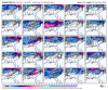
Like I’ve been saying for weeks now that STJ ain’t going anywhereAs you'd probably expect for a central Pacific MJO event coupled w/ a NINO leaning base state, the southern stream is very active in the longer term on the GEFS.
View attachment 30357
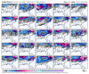
I see nothing wrong with the eps there at allIn all seriousness the EPS wasn’t great compared to previous runs but still solid. GEPS looks great.
View attachment 30362View attachment 30363
I see nothing wrong with the eps there at all
Ok let's unpack a few things here. #1 we all bust at some point when you make a forecast that's the reality of it, I busted hard thinking the pattern would change in early january, oops it didn't life goes on. #2 saying it's only going to snow in the mountains is a bold statement given the mjo and ensemble prediction. #3 winter isn't cut short we still have over 50% of our snow climo left and if you look at the period with the highest frequency of events we are just now approaching peak. #4 no one is saying stop posting but you did completely go from extreme A to extreme B and it really seemed more like bittercasting. #5 please remember we are all here for constructive discussion if we as staff feel like people are going outside of that we will take care of it. #6 building off of that if you want help with things just ask, no one knows it all but if you are unsure of something pose the question.Okay, fair enough! That comment I made saying, as I see as of now, just some cold shots with minor chances outside of the mountains is based off of thinking realistically. This is the southeastern US and most of the time, no major winter storms verify that shows up in the mid to long range. The pattern is crap and it's January, the time window is already cut short for a winter storm this month.
So what that I made snow/winter storm maps that turned out wrong. At least I tried and put some serious effort into them. If I don't know what I'm talking about or if I get something wrong about the models, just say so. Just don't sit there and say, "you don't know what you're talking about" or saying I basically suck. I could have huge potential in the meteorology field by providing custom maps and predictions, but I can't never improve my predictions if nobody never helps me out if I'm wrong about something. I get bashed every winter year and I'm so over it. If nobody helps me with my predictions and sits there saying, "you don't know what you're talking about" everytime, I'll just stop posting then, good grief.
Sent from my SM-A102U using Tapatalk
Sky healing is not a actual thing and I'm not sure who started this term although I remember Wilkesdud saying if every other post back on AmWx. The truth is, back to back storms have happened when good patterns that lock in, you can go to webberweather.com and look at the years and view the dates that are back-to-back with snow storms. The only way it doesn't happen is if said pattern is transient (aka transient blocking, transient +PNA, etc)...it might be a bias to say we need "healing" instead of just saying it doesn't snow often in the south and that's why it's not snowing again in a relatively short period of time following a big snow.It is highly unlikely (but not impossible) to have two storms back to back, only drawback is that the sky has to have time to heal. I seem to remember 2 storms back to back in 1979 or 1980 but my memory ain't what she used to be.
Exactly it really just takes such a perfect pattern in the SE to get snow that back to back events is low on the chance of happening scaleSky healing is not a actual thing and I'm not sure who started this term although I remember Wilkesdud saying if every other post back on AmWx. The truth is, back to back storms have happened when good patterns that lock in, you can go to webberweather.com and look at the years and view the dates that are back-to-back with snow storms. The only way it doesn't happen is if said pattern is transient (aka transient blocking, transient +PNA, etc)...it might be a bias to say we need "healing" instead of just saying it doesn't snow often in the south and that's why it's not snowing again in a relatively short period of time following a big snow.
He can speak for himself but I thought he was being facetiousSky healing is not a actual thing and I'm not sure who started this term although I remember Wilkesdud saying if every other post back on AmWx. The truth is, back to back storms have happened when good patterns that lock in, you can go to webberweather.com and look at the years and view the dates that are back-to-back with snow storms. The only way it doesn't happen is if said pattern is transient (aka transient blocking, transient +PNA, etc)...it might be a bias to say we need "healing" instead of just saying it doesn't snow often in the south and that's why it's not snowing again in a relatively short period of time following a big snow.
I see nothing wrong with the eps there at all
I'd rather see the lowest NH heights on our side of the pole. 500mb heights in the eastern 3rd of Canada are not impressive for this time of year, not by a long shot. It's a better look than the previous 6 weeks of dumpster juice, but still not solid imo.

No such thing as healing. But..usually the s/e can use up or deplete dry cold air at the surface with one storm and rain on the second. And tracks of low pressure are very unique like hurricanes which alter lots of things with qpf and temps.It is highly unlikely (but not impossible) to have two storms back to back, only drawback is that the sky has to have time to heal. I seem to remember 2 storms back to back in 1979 or 1980 but my memory ain't what she used to be.
I keep seeing 3 potentials that keep popping up: Jan 21, 24, 26I went back and looked at the individual GEFS ensembles and many are indicating back to back southeastern snow storms.. very similar to 2014 with what i’m seeing