Euro at 144 pretty much the same as the 0z GFS... now the funhouse mirror games begin: 

My gut feeling is the Euro op is wrong, or slow/delayed. We'll see what the EPS brings. And tomorrow, etc.


Snowfall mean just beefed up quite a bit in the GEFS as well


Mean is the highest I’ve seen the entire winter! Member 6 Lol.


Sent from my iPhone using Tapatalk
Still would like to start seeing the Euro Op show some colder solutions. Obviously the EPS is looking good in the long term, but I do not start getting hopeful until the Op also shows it. No doubt the pattern is changing, but last nights euro showed what can screw up a colder pattern with it sending the colder air to the other side of the globe just when we change to a better pattern. I am still optimistic things have got to be better, and it will at least occur during our coldest of time of the yearYeah luckily the EPS does not support the rouge euro solution .. sometimes you just get spoof operational runs .. how the cookie crumbles sometimes .. now we must wait for 12z

Yeah. Euro not biting ... it won’t take much to beat this crappy pattern of winter we are in.Still would like to start seeing the Euro Op show some colder solutions. Obviously Thur EPS is looking good in the long term, but I do not start getting hopeful until the Op also shows it. No doubt the pattern is changing, but last nights euro showed what can screw up a colder pattern with it sending the colder air to the other side of the globe just when we change to a better pattern. I am still optimistic things have got to be better, and it will at least occur during our coldest of time of the year
I really like the Cutoff low in the SE the GEFS advertises. If we can get that to become more progressive in future model runs, we'll be in business.If you take the nhem view of 500mb heights on tidbits and loop the entire run of the gefs and geps you can see a lot of fun stuff happening. The main area of interest to me is in east asia to the western north America coast. Watch how initially the okhotsk low tries to get going and force a taller Pacific ridge, that construct gets interfered with but the fracturing ridge eventually leads to smog troughing to beat the SE ridge back, it also ruins the stability of the entire Pacific pattern. Now as you progress out toward d5 we do it again, okhotsk low, ridge into AK. This time as the trough drops into the PNW the high has been shoved far enough north the PNW trough splits with part retrograding under the ridge and part progressing into the US. After that the okhotsk low extends into the aleutians big ridge goes into AK, you start to impinge on the tpv.
There are going to be a lot of iterations of this development over the next 5 days especially on the operational models since its not exactly a clean evolution. Once we get the 2nd surge of ridging into AK we will probably see less wild swings and have a better idea of what's coming up.
Now if you want to really hypothesize this pattern could go full bore freeze for the central and eastern us. It could also develop and be under cut and we lose the AK ridge or we start getting the center of the AK ridge too far north and energy starts retrograding under it and you have the ugly -pna again.
Sent from my SM-G975U using Tapatalk

I agree. I don’t think I’ve ever seen CLT with an ensemble mean of 3.5 inches that far out. One thing to keep in mind is that we might see some wild swings in the operational models over the next several days....this happens quite a bit as pattern changes approach.This right here may be the best evidence we’ve had in a year that something is cooking.
Sent from my iPhone using Tapatalk
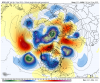
It looks as if the GEFS is trying to elongate and split the TPV into two areas of cold air, one of the other side of the pole and the other piece over Canada and the US, which Judah mentioned yesterday about the 00z GFS doing the same thing.Just going to save this image. Either we look at it like holy crap it nailed it or what could have been
Sent from my SM-G975U using Tapatalk

I saw that pretty strong signal on the vort maps too. Even the geps are hinting at getting more of a split flow look post 240. I almost wish I could unsee this to be honest and I really wish the eps mean was a little more enthusiastic.I really like the Cutoff low in the SE the GEFS advertises. If we can get that to become more progressive in future model runs, we'll be in business.


Agreed. Just using the canadian ensembles as an example since they are a little more emphatic about the progression here. Troughing in east asia, ridging in ak goes poleward, Pv starts getting interrupted and elongated part of it settles into Canada the rest is over Siberia back into the east asian low. Suddenly you gave a large lobe of the pv descending south through canada, ridging over the pole into Greenland and a cold US pattern. This is the evolution that we saw attempted in late December that got me excited but a bad mjo phase and low aam didn't help. This time with hopefully a more favorable mjo progression or at least some poleward propagating +aam from the recent spike we can pull it off.It looks as if the GEFS is trying to elongate and split the TPV into two areas of cold air, one of the other side of the pole and the other piece over Canada and the US, which Judah mentioned yesterday about the 00z GFS doing the same thing.
Sent from my SM-J727U using Tapatalk


It is.I think this is the CFS mjo but I'm not 100% sure
View attachment 30143
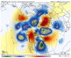
That's interesting does the eps keep that - height anomaly around the pole post d10?Looking at heights on EPS I am surprised it's registered as a +EPO while GEFS/GEPS is solidly negative.
View attachment 30146
View attachment 30140View attachment 30141View attachment 30142
It's a good example of how the calculations don't always exactly match the pattern effect. Sort of like on the other side, sometimes we see a -NAO and the thing is so far east, we get no benefit here. In this case, it seems like the opposite. I don't know exactly how the numeric values of the EPO domain are calculated, but you have to think the big blue, deep PV NE of AK is the culprit.Looking at heights on EPS I am surprised it's registered as a +EPO while GEFS/GEPS is solidly negative.
View attachment 30146
View attachment 30140View attachment 30141View attachment 30142