• Hello, please take a minute to check out our awesome content, contributed by the wonderful members of our community. We hope you'll add your own thoughts and opinions by making a free account!

Pattern January 2020 - Operation Thaw Alaska

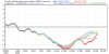
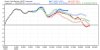
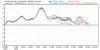
The CMC ens has been colder than the other two for several days. Unfortunately, it carries the strongest cold bias for the E US of the 3 major ensembles. So, this may be a function of bias.

This isn't a function of its cold bias, the Canadian just simply has a better Pacific pattern than the other 2 model suites w/ a deeper more extensive trough over eastern Russia that nudges the GOA ridge eastward. It's important to look a little beyond these stereotypical biases to assess why "x" model is producing "y" solution. Could you argue this cold bias is a function of a more intrinsic model bias such as one that produces weaker GOA ridges and stronger Kamchatka lows? Maybe, but again that requires more in depth analysis than sweeping the model under the rug because it usually is "x" biased.
 
Even with its cold bais...nice changes from just 12 hrs ago...
5744a9e64d0597a28e7f1e8c89375a5a.png
1ab1f32f3669e3f93fc1c7b0ccfb98fe.png


Sent from my iPhone using Tapatalk

I think the cmc has a "it's always wrong bias", no matter what it shows. If we're depending on the cmc, our winter is in pretty bad shape, imo.
 
I think the cmc has a "it's always wrong bias", no matter what it shows. If we're depending on the cmc, our winter is in pretty bad shape, imo.
There is no doubt this winter has been bad so far and just trying to find any positive I can at this point. I put most of my chips on whatever the EPS says.
 
I agree, with the NPAC ridge where it's at, if it can wobble east over AK from time to time it will dump cold HP into the conus.

Makes me cringe looking at the evolution of the GEFS though...the pacific sure looks stable but with a building Scandinavian ridge. Reminiscent of Feb 2018 and 2019. Maybe this is our dominant winter pattern and we have to make the most of it.

View attachment 29807View attachment 29808

View attachment 29809

After watching the EPS come in....Now I wish I had waited an hour to look at the EPS before I posted this.

giphy.gif
 
The GEFS is pretty much on an island here trying to blow up the Aleutian ridge again ~300 hrs. The EPS supports the Canadian ensembles more in this regard & thus the pattern starts breaking down by ~ Jan 20th to something far less hostile but still not terribly favorable for wintry weather. There's more to this than "x" model suite is cold biased more than "y" suite.

download (22).png

download (21).png
 
After watching the EPS come in....Now I wish I had waited an hour to look at the EPS before I posted this.

View attachment 29820

I suspect this could be some manifestation of the GEFS's long-range -EPO bias which is likely tied to how it handles waves that interact with the Himalayas, now just shifted equatorward & westward instead of over Alaska.
 
The GEFS is pretty much on an island here trying to blow up the Aleutian ridge again ~300 hrs. The EPS supports the Canadian ensembles more in this regard & thus the pattern starts breaking down by ~ Jan 20th to something far less hostile but still not terribly favorable for wintry weather. There's more to this than "x" model suite is cold biased more than "y" suite.

View attachment 29818

View attachment 29819
This is a much better progression and something I hope we keep seeing steps toward. It's still probably going to have that Pacific-air-mass-influenced feel to it, but it will hopefully more easily lead to better things down road.
 
the Canadian just simply has a better Pacific pattern than the other 2 model suites w/ a deeper more extensive trough over eastern Russia that nudges the GOA ridge eastward

Webber EPS and especially Canadian have way better GOA ridge placement and orientation. All will be boil down to exactly where the GOA sets up shop. Funny the GEFS and Canadian have the same MJO forecast. So what exactly is causing the forecasted placement of the GOA on the Canadian to be more east based ?
 
This is a much better progression and something I hope we keep seeing steps toward. It's still probably going to have that Pacific-air-mass-influenced feel to it, but it will hopefully more easily lead to better things down road.

I think the EPS MJO forecast into phase 6 is too weak & thus also wrong when compared w/ other NWP models which partially explains the discrepancies between it and the GEFS, but I also think the GEFS is overselling the extent & amplitude of the Aleutian ridge beyond day 10 as it often does w/ North Pacific anticyclones.
 
This isn't a function of its cold bias, the Canadian just simply has a better Pacific pattern than the other 2 model suites w/ a deeper more extensive trough over eastern Russia that nudges the GOA ridge eastward. It's important to look a little beyond these stereotypical biases to assess why "x" model is producing "y" solution.

Part of that cold bias is a cold pattern bias just as is the case for the GEFS cold bias. My educated guess is that that is playing a role in this. The CMC ens has been colder for days. We'll see if it scores here. I'm not betting on it right now, but I hope it is right for a change.

Meanwhile, the EPS is colder than its last run and it has been stuck on hour 318 for 20 minutes.
Well every case is different and it’s important to understand how said bias plays into each case rather than broadbrush very general biases, I.e model biases are state dependent to a large extent. The GEFS has a LR cold bias but already shows a torch in the SE US, based on that logic we should automatically assume an even warmer pattern but that’s not how this works. The EPS is basically showing a similar pattern to the CMC ensemble so I would not immediately brush it under the rug. As far as I’m concerned the gefs and geps verification rates are similar in the extended, the one that agrees with the EPS (geps) is more likely to be right
 
Easy to see why the EPS looks so much better than the GEFS. North pacific ridge finally backs away to the International Dateline and is suppressed, whereas its amplified & over the Aleutians on the GEFS.

North Pacific blocking is great so long as either we have a very mature, poleward -EPO w/ ridging breaking into the Pacific-Arctic or if this ridge is confined to the Western North Pacific (near or west of the dateline), anything in between usually invites disaster (-PNA)

download (25).png

download (24).png
 
I hope it's not a headfake. Seems like the Euro had a +pna look several runs ago that it quickly lost. Anything is better than seeing that blue blob over BC and Washington. I'll always take an EPO in the GOA extending up into the Arctic that acts as a pseudo +PNA or a +PNA. They can work around the lack of a cooperative Atlantic. The Atlantic itself can't get it done when the Pacific is a disaster.
 
One thing we can be pretty certain of for the next 10 days is that we certainly won’t be lacking in rainfall.

Both the Gfs and the Euro are showing some pretty hefty totals for parts of the southeast especially Northern Alabama and Georgia. I have also noticed some consistency to them as well.

Euro has a solid 4-8 inches of rain from about Central Mississippi to the Appalachians over the next 10 days.
307E18C6-C0DD-4FE8-B30F-6C07F5FEEFD3.gif

Gfs has even more rainfall with totals in the 5-9 inch range in Georgia and Alabama and some pockets over 10 inches in the next 10 days
068B8E9F-0B13-47CA-AC98-078C45D7FB93.gif

All in all, looks like at the very least we will have a lot of rain to deal with until hopefully we get a pattern change later in the month. At least we wont be dealing with a drought again for a while.
 
Easy to see why the EPS looks so much better than the GEFS. North pacific ridge finally backs away to the International Dateline and is suppressed, whereas its amplified & over the Aleutians on the GEFS.

North Pacific blocking is great so long as either we have a very mature, poleward -EPO w/ ridging breaking into the Pacific-Arctic or if this ridge is confined to the Western North Pacific (near or west of the dateline), anything in between usually invites disaster (-PNA)

View attachment 29822

View attachment 29823
I’m guessing those extremely low heights trapped north of Russia and not spilling into the east coast are a necessary evil if we want to see this +PNA develop? Or would this all be a result of the MJO progressing into the Western Pacific?
 
Here's a great example of how you can have 2 identical RMM MJO forecasts, yet still have significantly different -VP200 configurations. This is largely because RMM doesn't handle the MJO quite as effectively in the Western Hemisphere & it doesn't explain but a fraction (~33%) of the total variability, and is comprised of several variables, of which differences in one or a few of them are effectively masked out. RMM also doesn't explicitly include VP200 and doesn't capture western hemisphere MJO events quite as well.


diagram_40days_forecast_GEFS_member.gif

CANM_phase_20m_small.gif

gfs-ens_chi200Mean_global_10.png

gem-ens_chi200Mean_global_10.png
 
I’m guessing those extremely low heights trapped north of Russia and not spilling into the east coast are a necessary evil if we want to see this +PNA develop? Or would this all be a result of the MJO progressing into the Western Pacific?

The Kamchatka Peninsula/NE Russia/Okhtosk trough is a function of both the MJO moving into the Western Pacific (which releases latent heating into the mid-latitude jet and results in a poleward shift of the subtropical high) and "intrinsic, internal" variability in the storm track. As the old saying goes, there is more than one way to skin a cat, you don't always need a huge Aleutian low to generate +PNA, having a vortex over NE Russia (+WPO) in the right place at the right time of the year w/ the proper initial state in the NP storm track is another way to create one. Obviously, the further you get from the west coast and SE US, the more dispersion matters, which tends to break down the teleconnectivity of these relationships.
 
After watching the EPS come in....Now I wish I had waited an hour to look at the EPS before I posted this.

View attachment 29820

I don't know man, I'm glad that if it's one long range ensemble suite that shows us potentially leaving a shutout pattern it's the EPS. But whether or not it actually comes to fruition and for how long are huge leaps of faith for me at this point. We all know that, so I guess I just say that to say when in doubt I go with persistence until the models scream otherwise. Here's hoping the long range EPS +PNA is the first step out of the dungeon.
 
I am a bit surprised at how long the wet pattern is lasting. If it ever manages to snow I would think western NC would be dealing with a massive river flooding pattern well into spring. No sustained cold but plenty of moisture would lead to rapid snowmelt combined with these heavy rain events. The current lack of snow may be a good thing for those living in flood prone areas.
 
I think what Webber has basically been saying to us (correct me if I’m wrong Webber) is that why are we trusting the untrustworthy models in the weather community we need to trust the one model that’s been consistently trustworthy in its forecasts which would be the euro and its ensemble members .. and if we trust the truth worthy model than we have a lot to be happy about for late January and into February
 
I’m more interested in the direction they’re headed and not as much in that all 3 teleconnections will hit >4 sigma over the next week
 

Attachments

  • 123DC43F-15D8-436E-80D5-AC843559058C.jpeg
    123DC43F-15D8-436E-80D5-AC843559058C.jpeg
    103.2 KB · Views: 32
  • 8B42BB11-1D79-4310-A939-19580B9E80E2.jpeg
    8B42BB11-1D79-4310-A939-19580B9E80E2.jpeg
    108.4 KB · Views: 31
  • 1DAB0715-FF5A-4603-B9EC-E79E75F79DBE.jpeg
    1DAB0715-FF5A-4603-B9EC-E79E75F79DBE.jpeg
    105.3 KB · Views: 31
And it still looks warm in the SE.
It takes a bit for the effects of such -NAO to transverse into the weather here in the south East ... if u keep looking at the model as it goes out you will what this type of pattern produces there was about three major back to back major winter storms for the southeast after this -NAO
 
Back
Top