ATLwxfan
Member
I booked a place in Banner Elk just in case. Free cancellation until the 31st so why not.
I’m hoping the pump is primed for President’s Day weekend
Sent from my iPhone using Tapatalk
I booked a place in Banner Elk just in case. Free cancellation until the 31st so why not.
Nice southern slider at 288.


#LakesLow ?Yeah I give up...

Sent from my iPhone using Tapatalk
Yeah I give up...
Sent from my iPhone using Tapatalk


Big SE storm at 336! This is the one!
the funny thing is, the progression is similar to what the CFS has been showing for a while now ??Big SE storm at 336! This is the one!


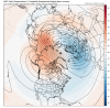
Decent late run upper air pattern being depicted ?View attachment 31918
You could drive to Savannah...Yeah I give up...
Sent from my iPhone using Tapatalk
Amen
Dear lord! What do we have to do to make this happen
Sent from my iPhone using Tapatalk
There is that pesky -NAO trying to finally make an appearance ... this is begging the southeast to get multiple snow eventsDecent late run upper air pattern being depicted ?View attachment 31918
I mean a true arctic front pushing into an already cold airmass ... would be a wild squall line of snowWow big time strong winter clipper system at the end of the GFS run ... going to give some good snow to a lot of us

So far ?Run of the year
View attachment 31920
Its about time for the broken clock to be right.Meanwhile, day 10 CMC not nearly as enthused with SE cold...at least it seems to me...as the GFS.
Meanwhile, day 10 CMC not nearly as enthused with SE cold...at least it seems to me...as the GFS.
Look at that ridge on the move up into alaska. CMC was about to drop the cold mother loadMeanwhile, day 10 CMC not nearly as enthused with SE cold...at least it seems to me...as the GFS.

Ehhhh be careful here that's going into the SW first and the SE ridge would respond but you are probably getting enough aleutian low and ridge into AK that it may be a short term dealLook at that ridge on the move up into alaska. CMC was about to drop the cold mother loadView attachment 31921
Extrapolating of course..if we can get that big ridge to dislodge the cold over Alaska it could be a big conus trough. Also looked like the CMC was about to pump heights around Greenland towards the end as well..even still, I’m extrapolating the CMCEhhhh be careful here that's going into the SW first and the SE ridge would respond
#LakesLow ?
Yeah I was being facetious. Hopefully the depicted pattern happens. I think we would all appreciate thatThere were just examples posted with SE Winter Storms with a GL Low.
Anyway, the Southern Slider looks like a classic deep south winter storm but until it gets under 150 then it's just Alexa Bliss (eye candy).
Gefs really hates the strat pv and wants to start warming/disruption around D5 and ends with this. It certainly wouldn't hurt our chances to interfere with the overall polar structure


pretty sad that we haven't even had our usual fantasyland storms until now and its late january.One run can really get this place going. Come on Euro.
Sent from my iPhone using Tapatalk
To piggy back off of this and what @Myfrotho704_ was saying. That big phasing system to begin February would set all of this up. No high pressure to be found yet GFS spits out 3 straight winter storms for the SE. We’re rooting for a big phase to start the monthRun of the year
View attachment 31920