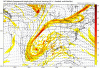
They do and they don't. I recent years, that feature has in no way aided in southern snow the bulk of the time. It can, under some circumstances, not be a hindrance, but you're going to have to work really really hard to convince me that it helps more than it hurts. About 90% of that feature shows up, a widespread winter storm here happens not. Maybe in a different pattern where there's blocking or something, it may not hurt us. But you can just look at the temp map above and see the effect of its presence.some people claim they don’t hinder a snowstorm setup, but I beg to differ. As do many others
-
Hello, please take a minute to check out our awesome content, contributed by the wonderful members of our community. We hope you'll add your own thoughts and opinions by making a free account!
You are using an out of date browser. It may not display this or other websites correctly.
You should upgrade or use an alternative browser.
You should upgrade or use an alternative browser.
Pattern January 2020 - Operation Thaw Alaska
- Thread starter KyloG
- Start date
They do and they don't. I recent years, that feature has in no way aided in southern snow the bulk of the time. It can, under some circumstances, not be a hindrance, but you're going to have to work really really hard to convince me that it helps more than it hurts. About 90% of that feature shows up, a widespread winter storm here happens not. Maybe in a different pattern where there's blocking or something, it may not hurt us. But you can just look at the temp map above and see the effect of its presence.
No phase, split flow, you are going to see something like that there. Is this really thought to be some type of semi permanent thing?
Attachments
I'm not following ya. Sorry man. It's early, I'm off work, and I haven't had coffee yet!No phase, split flow, you are going to see something like that there. Is this really thought to be some type of semi permanent thing?
Edit: You saying it's there because there wasn't a phase?
MichaelJ
Member
I think he is saying that when we do have a phase the GLL has no effect so it is not a permanent or semi permanent thing, depends on other factorsI'm not following ya. Sorry man. It's early, I'm off work, and I haven't had coffee yet!
Edit: You saying it's there because there wasn't a phase?
Oh ok, gotcha. Yeah, when that energy phases in, I get that scenario. And yeah, I didn't mean to indicate it's a permanent feature. But if it's there when the southern stream wave moves by, assuming no phase, with marginal temps, it is going to do more harm than good most of the time.I think he is saying that when we do have a phase the GLL has no effect so it is not a permanent or semi permanent thing, depends on other factors
Oh ok, gotcha. Yeah, when that energy phases in, I get that scenario. And yeah, I didn't mean to indicate it's a permanent feature. But if it's there when the southern stream wave moves by, assuming no phase, with marginal temps, it is going to do more harm than good most of the time.
What you both said. The 0z GFS kept the stream separate and fed nothing into the southern stream like the 18/6z's did, sorry that lakes low thing is just one of those things that grinds my gears.
D
Deleted member 1449
Guest
All I know is I'd prefer an "H" over the Lakes rather than an "L." Either way, the EC solution is probably not happening any way.
ATLwxfan
Member
Sent from my iPhone using Tapatalk
Wow and the upstate gets rain
No one outside the mountains is getting snow with a SLP track up the Piedmont.
Ron Burgundy
Member
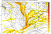
Would you mind posting this for western GA / East AL?Wake up everybody! 3+ feet in WNC! Code red!View attachment 31891
Here was the whole mapWould you mind posting this for western GA / East AL?

I'm surprised the severe threat isn't getting a little more conversation this morning. Pretty stout high shear low cape with winds backing across the Carolinas.
Yeah that is true I suppose we can’t make a separate thread but could be a pretty nasty line later todayI'm surprised the severe threat isn't getting a little more conversation this morning. Pretty stout high shear low cape with winds backing across the Carolinas.
NorthGaWinter4
Member
Think we may have a storm hereIcon is about to get crazy at 177
Feel free to start the thread if you want I don't have an issue with itYeah that is true I suppose we can’t make a separate thread but could be a pretty nasty line later today
Sub 530 thickness across alot of NC as this pup is getting ready to spin up the goods. Ashame it doesnt go out futher. Ever notice the ICON will paint rain as the precipo type all the way to the 520 thickness line, sometimes lower. Thats why its R/S line is always way out of whack (much futher N) than other globals. Thanks for making me look SD! Look at that NS energy coming into the back side of the SS

D
Deleted member 1449
Guest
One thing is certain, we are about the get very active, with one southern stream wave after another. Maybe we can get lucky, but it's going to require a perfectly-timed phase, I'm afraid. I don't like the chances of that.
NBAcentel
Member
GFS starting to look like last nights CMC, it’s just 925s are to warm, still has time to be something but the ensembles look the same, with warm BL issues, such a shame 

NBAcentel
Member
And yes, that trend shows how bad the GFS is, that’s absurd and terrible for being inside hour 150, absolutely ridiculous
packfan98
Moderator
Oh there’s a GL low coming...Interesting...
The next northern steam wave is coming in and there isn't enough blocking. That doesn't end well for usOh there’s a GL low coming...
packfan98
Moderator
Apps runner on this run.The next northern steam wave is coming in and there isn't enough blocking. That doesn't end well for us
D
Deleted member 1449
Guest
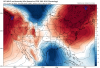
very similar to last night's EURO--just farther west. But check out those deep blues embedded within the greens and yellows. Fun to look at.

change dates on other thread. Don't need a thread everytime wind blows lolYeah that is true I suppose we can’t make a separate thread but could be a pretty nasty line later today
They do and they don't. I recent years, that feature has in no way aided in southern snow the bulk of the time. It can, under some circumstances, not be a hindrance, but you're going to have to work really really hard to convince me that it helps more than it hurts. About 90% of that feature shows up, a widespread winter storm here happens not. Maybe in a different pattern where there's blocking or something, it may not hurt us. But you can just look at the temp map above and see the effect of its presence.
As Shane said, the reason for the warm temps is the streams are seperate, so in effect you are getting WSW flow aloft with no northern stream influence so of course it will be too warm. The other reason the temps rise on the chart posted last night was daytime heating. Most if the time when you have a weak low pressure over the lakes it is due to a PV lobe sitting over the area which does not kill cold air advection for us in the south.
Examples include 12/8/17 which had a weak low pressure over the lakes. 02/25/15 had a system over MO.
D
Deleted member 1449
Guest
It's not even an Apps runner. It's a TN/OH Valley cutter. I guess we'll just have to watch and see if there are any eastward adjustments going forward.
I was thinking the same thing. I think today's 12z Euro run is going to be very interesting again.very similar to last night's EURO--just farther west. But check out those deep blues embedded within the greens and yellows. Fun to look at.
LovingGulfLows
Member
- Joined
- Jan 5, 2017
- Messages
- 1,499
- Reaction score
- 4,100
Where does SoutheastRidge live in Ohio? GFS might be trying to give him a blizzard.
Yep the southern wave was so late then that phasing northern stream came in and NW it wentApps runner on this run.
Storm5
Member
The mountains might be the place to be next weekend
Sent from my iPhone using Tapatalk
Sent from my iPhone using Tapatalk
Of NevadaThe mountains might be the place to be next weekend
Sent from my iPhone using Tapatalk
Storm5
Member
Of Nevada
No need . Eastern tenn and western NC mountains could do well. They scored this run on the backside with upslope. Last night euro dropped close to a foot in the region


Sent from my iPhone using Tapatalk
12z GFS was actually close to a phase. I'm excited to see what the 12z Euro will show today. If a phase does really happen, this is going to be one monster storm.
ATLwxfan
Member
On to the Euro. GFS isn’t far from something more. Just need that pig to dig.
Sent from my iPhone using Tapatalk
Sent from my iPhone using Tapatalk
Blue_Ridge_Escarpment
Member
Don’t look now but GFS is getting very close to something mid week for upper south before the big boy comes in.
I booked a place in Banner Elk just in case. Free cancellation until the 31st so why not.The mountains might be the place to be next weekend
Sent from my iPhone using Tapatalk
GeorgiaGirl
Member
12z GFS was actually close to a phase. I'm excited to see what the 12z Euro will show today. If a phase does really happen, this is going to be one monster storm.View attachment 31917
It did actually phase.
Just in a way that would make the southern stream part of it end up heading straight north and outside of that crazy deform band in parts of Tennessee and upslope/backside snows, it might...be severe weather that's more interesting in the southeast on this.
There's ways to adjust this to make it interesting for I-85 west or at least the mountains (even outside the upslope), but for east of I-85, a lot of help would be needed (and I'm not expecting it, just saying there).
2nd edit: Maybe with this being a phasing situation, the problem with heights being too low won't be as big of an issue. Maybe it's about figuring out where the needle will be threaded.
packfan98
Moderator
Nice southern slider at 288.