The CFS has the idea of a storm that can produce its own cold. It would be a sloppy wet snow.

That LP in NE where we would love to see a HP is really jacking this up
Starting to stretch the tPV day 12+. Long ways out there but it's nice to see., All the global ensembles agree on this more or less.
View attachment 31742


Starting to stretch the tPV day 12+. Long ways out there but it's nice to see., All the global ensembles agree on this more or less.
View attachment 31742


With as much skepticism that's being hurled towards the favorable pattern being modeled in the longer-term, it's not like the basic state forcing won't be favorable for it this time. Unlike in the first half of winter, east Indian Ocean convection at this time of the winter (late January onward) actually favors cold & troughiness in the eastern US and this is precisely what the EPS is forecasting in early February.
View attachment 31754
Phase 2 MJO regressed 200mb height anomalies centered on February 10th.
View attachment 31755
Heads or tails?Personally, I think once the forcing returns back to the Maritime Continent, we may see a return to a milder pattern (~mid Feb (ish)) but that remains to be seen. Fwiw, you can see the seeds of our favorable pattern's demise being sewn at the very tail end of the 12z EPS w/ our nice trough over the central North Pacific disintegrating, hinting at retrogression of our west coast ridge back to the NE Pacific (thus -PNA? (again))


It's not just you. We've been chasing these turd duds all winter. It's all we've got, I guess, but this one is likely going to swirl around the toilet bowl too, unless it can find a magical way to get much stronger. I mean, I wouldn't rule out some wet flakes on the NW fringe, but that's about the extent of it, IMO.Maybe it’s just me but it’s hard to get even remotely excited about that system late week next week that’s showing on the GFs . It’s not like it’s in the upper 30s and we just need a little temp help .
It’s mid to upper 40s for most verbatim . I’m more interested in the first week of February when the PNA looks to go positive . The 12z euro was headed in the right direction with the trailing shortwave . But it’s a long ass way out there

Sent from my iPhone using Tapatalk
Ive always said that a + PNA is the higgest most favorable signal for the SE to root for. The mac -daddy of them all. Thanks Webb for those stats.
Maybe it’s just me but it’s hard to get even remotely excited about that system late week next week that’s showing on the GFs . It’s not like it’s in the upper 30s and we just need a little temp help .
It’s mid to upper 40s for most verbatim . I’m more interested in the first week of February. The 12z euro was headed in the right direction with the trailing shortwave . But it’s a long ass way out there
Sent from my iPhone using Tapatalk

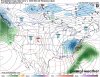
Patience RC! You’ve got to set the table before you can feast!It's not just you. We've been chasing these turd duds all winter. It's all we've got, I guess, but this one is likely going to swirl around the toilet bowl too, unless it can find a magical way to get much stronger. I mean, I wouldn't rule out some wet flakes on the NW fringe, but that's a out the extent of it, IMO.

If ... if ... if that happens, it's no snow for me (yet then is there ever?), but at least it's not shorts and t-shirts yet ... makes a gator very happy to see that map ... Thanks ...Patience RC! You’ve got to set the table before you can feast!View attachment 31759
As you and most here know, we've been badly fooled numerous times this winter. So, whereas I'm always hopeful for a true cold dominated pattern finally getting here (and do expect that to actually start ~late Feb) and a cold looking EPS always excites the heck out of me, I'm not betting on it earlier than late Feb regardless of what the models are showing due to their horrible performance when it looks favorable for cold, especially until the indices overall get better. Fool me once, shame on you. Fool me twice, shame on me. Fool me over and over, ...........
Hopefully, we won't need to wait til late Feb. Any earlier would be a huge bonus to me since I've not been expecting it. The MJO staying within or near the COD (a quick low amp 5) instead of going for another long, high amp 4/5 could only help imo.
With the current +AAM, maybe it will be different this time, especially if it lasts?
The EPS never bought into the EPO going negative and we are currently in the modeled BN pattern...it wasn’t that bad. Yeah, pattern collapsed and the GEFS was really bad at tanking the EPO.


Fabulous stuff!Indeed, the EPS never bought into the -EPO. And I don't think it has been bad as the GEFS overall. But don't forget that the EPS has had enormous swings from cold to much warmer in just one run. Example: Here's last Thursday's (1/16) 0Z EPS, which had solidly BN over virtually the entire US in the 11-15 (see images below) and which looked cold at the end:
0Z 1/16 6-10: cool SE, AN much of N US
View attachment 31762
0Z 1/16 11-15: cold SE and much of US
View attachment 31760
The very next run, 12Z on 1/16, had a whopping 24 fewer HDDs! From another BB per a met there:
"Yeah, that 12z EE was incredibly warmer. 24 less HDD's which is a ton for an ensemble in just 1 run."
12Z 1/16 6-10: N SE and A to MA much of N US
View attachment 31763
12Z 1/16 11-15: N SE and much of US
View attachment 31761
Then the next two EPS runs, the ones on 1/17, each continued the sharp warming to the point that the 12Z 1/17 run had an astounding 50+ fewer HDD than the 1/16 0Z run!!
12Z 1/17 6-10: A to MA much of US including SE
View attachment 31764
12Z 1/17 11-15: SE is a little AN; N to AN most of US other than SW
View attachment 31765
And the latest EPS (12Z on 1/22), despite some modest cool changes and a better look, is still AN much of the US in the 6-15 as it warmed a good bit further over the long weekend:
12Z 1/22 6-10: A to MA most of US
View attachment 31767
12Z 1/22 11-15: AN most of US
View attachment 31768
So, I'm advising extreme caution in buying into a colder pattern based on how the EPS looks in week 2. Perhaps it will be different this time?? Who the heck knows?
Note that the 1st 6 maps are 850 anomalies whereas the last 2 are 2 meter. That's because I have old 850s saved but not old 2 meter. I would have preferred to display only 2 meter maps if I could. But the general point is still clear.
")
I’m all in because I don’t think I’ll have another chance to be all in.I actually think this could* be our best shot. Yes, there won't be super cold air around, but we will have plenty of energy flying around and if we can actually time it right, EURO and GFS not far off, could be our best shot overall so far this lackluster winter.
I'm right there with you.I’m all in because I don’t think I’ll have another chance to be all in.
I was thinking the same thing. It’s really interesting how many possibilities exist in an ever changing system where there really is no cause & effect, it’s as if time is really just an illusion and each moment coexist with one another, as if there is a connection there. This is definitely an interesting period coming. Although not perfect which is completely fine, I’m just curious to see what the atmosphere decides to dish out these next few weeks.One of those weird cases where a +EPO/big Alaskan vortex is pumping our possible +PNA

Believe it or not, Temps are decreasing as the storm gets going, verbatim, the snow line would most likely shift south.Time for an old fashioned Mt Airy trip with that look!!
Didnt realize there was any CAA. Great news!!!Believe it or not, Temps are decreasing as the storm gets going, verbatim, the snow line would most likely shift south.


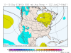
You’re looking at the wrong storm.Looking at soundings on the GFS it was very close as well precip didn’t evaporate this run as much and temps were boarder line
View attachment 31773
View attachment 31774
Oops I wasYou’re looking at the wrong storm.
my badNo problem. At least we still have more of the run to go, to see if the FV3 will bite.Oops i was
I believe this is that system now and the low placement is much better than the 18z run. However temps are an issue this run being in the mid 40’sNo problem. At least we still have more of the run to go, to see if the FV3 will bite.

I’m not thinking that wave itself is going to work out, but the one behind it also has my attention. There are so many waves, that I can’t pinpoint which one I need to pay attention to.I believe this is that system now and the low placement is much better than the 18z run
View attachment 31775