Ilovesnow28
Member
Hmmm 


Can someone either agree or disagree that we should now be looking at the Canadian model and it’s ensembles with a more higher regard .. even vs Gfs now? In other words is the Canadian more trust worthy now in what it shows

Unfortunately, if the EURO is right, the MJO looks to be headed to phase 5 and at a fairly high amplitude over the next 20-30 days. It basically meanders around 5 until late February which could be the death knell for most in the SE wanting snow. Not saying it will end up being right but I have a sick feeling in the pit of my stomach about it. We would need a miracle of timing and track to get lucky IMO if this occurs.
View attachment 31674
That's not a high amp phase 5. When it's near or within the circle, the MJO fluctuation doesn't have much of an influence. There are other major key factors within the pattern and not just the MJO, so results can vary. I do think the month of February will be better in terms of below normal temperatures and winter storm development verses this month.Unfortunately, if the EURO is right, the MJO looks to be headed to phase 5 and at a fairly high amplitude over the next 20-30 days. It basically meanders around 5 until late February which could be the death knell for most in the SE wanting snow. Not saying it will end up being right but I have a sick feeling in the pit of my stomach about it. We would need a miracle of timing and track to get lucky IMO if this occurs.
View attachment 31674
That's not a high amp phase 5. When it's near or within the circle, the MJO fluctuation doesn't have much of an influence. There are other major key factors within the pattern and not just the MJO, so results can vary. I do think the month of February will be better in terms of below normal temperatures and winter storm development verses this month.
Sent from my SM-A102U using Tapatalk
It's not a high amplitude phase 5 look because uncertainty and spread increase faster w/ range than actual signal. However, that doesn't necessarily mean a strong MJO event can't emerge in phase 5-6 again in February.


I would feel good about early Feb if I lived in WNC..they can kick ass and take names with marginal cold such as this. Big heavy rainers over the SE while places with elevation get buried

.gif")
soundings aren't awful.
View attachment 31695


Really not too far off. I'll be looking at the CMC and Euro to see if we come close.Even in the Atlanta area, this is pretty close to being wet snow w/ the melting layer below 900mb and surface temps in the upper 30s.
View attachment 31696


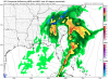
Honestly I saw this earlier when looking at the models and was surprised it wasn’t showing more in the way of snow outside of the mountains. That looks like a really good storm trackThis is really close to being heavy, wet snow on this run from GSO-CLT and points west.
View attachment 31692
View attachment 31693


I was taking a look at the Gulf SSTs and there is a warm blob of 26°C (about 80°F) which would induce convection/higher QPF? (Help me word that better?) with Gulf lows. I'm not sure if SSTs are above normal in the Gulf. (Still searching for SSTs maps for the Gulf.) @Webberweather53The subtropical jet really juices up the day 9 storm on the GFS w/ a clear link from the central Pacific. The warm, moist conveyor belt for any storm that attempts to get going at the end of January into early February will be quite potent.
View attachment 31699


Yeah gfs has trended to more NS phasing, which was once embedded in the Canadian ridge, nice western ridge, you gotta love/hate the Canadian ridge, helps shoves things/acts as blocking but it’s not really good for CAA View attachment 31698
Everything was too positive tilt but looked like it had plenty of time to go negative..extrapolating a crappy model of courseWell...Let’s see what the doc has to say...

CMC doesn’t have much moisture with it. Mainly throwing this out here because of the 850 temps...
Sent from my iPhone using Tapatalk
.gif")


as others have said, GFS was very close to a heavy wet snow for many across the SE. Here locally, you will notice once things get going a pocket of sub freezing temps at 850mb develops. The melting layer isn't awful, wouldn't take much more to fully support heavy wet snow.
View attachment 31711View attachment 31712View attachment 31713
yes sir I agree! I would think the EURO should have a storm, maybe not shown like this, but a bit further north from last nights run?A stronger surface low w/ more QPF & stronger cold advection would be able to take care of that.
as others have said, GFS was very close to a heavy wet snow for many across the SE. Here locally, you will notice once things get going a pocket of sub freezing temps at 850mb develops. The melting layer isn't awful, wouldn't take much more to fully support heavy wet snow.
View attachment 31711View attachment 31712View attachment 31713
Agreed. That H850 layer cools very quickly with the heavier precip. Nice look this far out.You would have fun with that. Very nice UVVs in the DGZ.