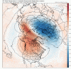
The end of the GEFS continues to look pretty similar to most of the LR GEFS progs so far this season...some ridging along the west coast with a trough through the center/eastern part of the country and the PV sitting over Greenland. The GEPS, as has also been the case most of the season, looks a bit better. Don't have access to the 360 EPS, but I assume it probably doesn't look better.
850s through the period look average, to slightly below, depending on your model of choice. So, it's not a torch, as others have said, and it's possible to sneak an event in here somewhere. But I'm just putting lipstick on the pig by saying that. We need something to shake up the pattern before the clock runs out. In mid-December, we were looking at early Jan, which became mid-Jan, which turned into late-Jan/early Feb. Now, we're likely out to mid-Feb before a better pattern sets in, if it does.
Maybe the GWO/AAM will help force a change, at least for a while. I don't know. The ensembles at range have been fairly useless this year, IMO. I'm sure the EPS has done the best, but it's still whiffed a few times. Basically, nothing showing a cold and wintry pattern has played out. The CFS is hot garbage. The JAMSTEC is a mess. The JMA is a dumpster fire. The only thing that's been a reliable longer range predictor is persistence, once winter started.
I still think (hope) we get into a one or two week pattern where we get some blocking somewhere across the north that will provide a sustained cold air feed into the eastern US. But I'm not really sure how we get there in time, at this point.


.png")