- Joined
- Jan 23, 2021
- Messages
- 4,603
- Reaction score
- 15,199
- Location
- Lebanon Township, Durham County NC
Sure seemed like the 3k and 12k wanted to have some freezing drizzle on the heels of the cold front tuesday especially on the north side of Atlanta
It’s going to be a crazy gradient tomorrow. I expect to leave work and drop at least 15 or more degrees on my drive home.I think you have a shot at some snow tonight, its going to be one of those wait and see what returns you get scenarios.
I'm 39.4F/33.4 down here. Not that it matters when there is no moisture and I will be approaching 60F tomorrow.
One thing I noticed on the 12k is that it was showing green returns over my area with a temp of 29F. Its tough to presume anything until a few hours before, its certainly possible, especially areas north and west.Sure seemed like the 3k and 12k wanted to have some freezing drizzle on the heels of the cold front tuesday especially on the north side of Atlanta
That could be really bad especially given how many elevated interchanges there is on the north sideOne thing I noticed on the 12k is that it was showing green returns over my area with a temp of 29F. Its tough to presume anything until a few hours before, its certainly possible, especially areas north and west.
Looking good here

It's juicing up down by the gulf, and that's got to come thru here, so now it's a fight with the slow moving cold air. I'm stuck at 42.4 for while. With that steep tilt, it's going to take a while to get here. And that usually means there is squat left for me when it drags thru, lol. You should do ok based on the returns....and the cold will find you sooner too.Best look of the NAM for here. I have 36 here. Gilmer County is 41 which is very odd to me.
They do, but timing is everything. If it's before dawn, it might be a problem on bridges and overpasses. If it's mid-morning, may not do anything but a light glaze on the trees. Ground is going to be relatively warm so not expecting problems with roads.Sure seemed like the 3k and 12k wanted to have some freezing drizzle on the heels of the cold front tuesday especially on the north side of Atlanta
Maybe down on your end. The ground around here is plenty cold and I have frozen ground in the shade even during a warm afternoon. Any moisture with mid 20s and we’ll be ice skating.They do, but timing is everything. If it's before dawn, it might be a problem on bridges and overpasses. If it's mid-morning, may not do anything but a light glaze on the trees. Ground is going to be relatively warm so not expecting problems with roads.


Yes, Lily Pond would be much different, I was talking about Atlanta and south, referring to the threat Dsaur mentioned.Maybe down on your end. The ground around here is plenty cold and I have frozen ground in the shade even during a warm afternoon. Any moisture with mid 20s and we’ll be ice skating.
 Still running with it
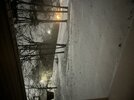
We’ve got 0.5” of snow on top of a 0.25” of ZR & IP… moderate rate coming down nowFlorence, AL looks to be getting smoked at the moment. What’s the ground truth look like there right now?

We had several hours of that. It changed over to all snow about 8:30 and coming down good.Still just sleet and freezing rain here in NW Huntsville. Temp here around 27
You should be in the hot tub soaking it all in lolWe’ve got 0.5” of snow on top of a 0.25” of ZR & IP… moderate rate coming down now
View attachment 142376
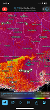
I am. I'm in Shelby county and I'm not wanting a second round of ice. But so be it if it is. Is will be nice to kill a few bugs here and thereEveryone is caught up on the snow north of me, but man this 0z runs tonight is a nice increase on the second round of ice. Is anyone seeing all this?

So metro ATL is in this now? Please keep that ice! ?? honestly, I would not shocked if the an ice storm happens in the metro especially NW ATL.View attachment 142380
Good gracious south Louisiana
Those amounts wouldn’t do damage.So metro ATL is in this now? Please keep that ice! ?? honestly, I would not shocked if the an ice storm happens in the metro especially NW ATL.
However, I would not be shocked if precip overperform. That is what I was trying to type lol.Those amounts wouldn’t do damage.
")

Don’t do it. Dwarf sisters will let you down every time. Every. Time.View attachment 142375Still running with it