Area Forecast Discussion
National Weather Service Morristown TN
335 PM EST Sun Jan 14 2024
...New SHORT TERM, LONG TERM...
.SHORT TERM...
(This evening through Monday Night)
Issued at 319 PM EST Sun Jan 14 2024
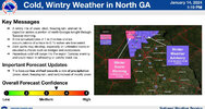
Key Messages:
1. Increasing confidence in a heavy snowfall, especially Knoxville
and north, exact placement of highest amounts will depend on where
exactly snow band sets up.
2. Potential still exists for a mix of precipitation types along the
Georgia border, lending to moderate uncertainty on snowfall totals
in the southernmost counties.
3. Precipitation late Monday night into Tuesday morning might switch
to a light freezing drizzle as snow comes to an end.
Discussion:
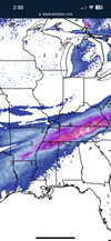
Mostly sunny skies across eastern Tennessee currently will give way
to the clouds associated with the incoming snowstorm. Expecting snow
showers to begin moving into the valley tonight, sometime between
00z and 06z for first showers. HRRR is a little quicker than the
HREF
mean, but siding on the side of caution given how timing has
gone thus far. It seems
likely at this point that snow will stick
as temperatures will be falling below freezing as snow arrives.
Therefore last preparations for snow should be completed this
afternoon and early evening. With the guidance continuing the
trend today to move the start time of snow showers up, elected to
begin the
warning at 00z tonight, the
winter weather advisory in
North Carolina will remain 06z.
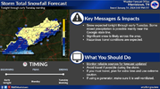
Snowfall has increased with this package, now expecting a broad
spectrum of 6 to 8 inches along and north of Interstate 40, with
another maximum along the Cumberland Plateau. This forecast is
slightly under the WPC guidance, and it seems likely that some
locations will accumulate higher amounts. Placement of these
localized higher snowfall amounts is uncertain depending on exact
placement of narrow bands of higher snowfall rates. The other
uncertainty in snow amounts continues to be along the border
counties with Georgia, where a brief mix of sleet seems probable
given the persistence in the high resolution guidance. For
temperatures tomorrow, stuck with persistence with the prior
shift. Some guidance, and the NBM, is warmer with the max
temperature, but it`s hard to reconcile that idea when no strong
advection is in place to power that warmth against the chilling
effect of ongoing snowfall.
Snow starts out tonight as generally
scattered, and guidance has
indicated a lessening or pause before becoming more steady
stratiform snow with embedded bands during the daytime on Monday.
While the HREF doesn`t suggest any 1"/
hr rates, steady snowfall will
lead to higher accumulations as Monday wears on. This translates
to road conditions steadily worsening, especially secondaries and
lesser frequented roads, as the day wears on. Monday night into
early Tuesday might feature light freezing drizzle on the backside
of the snow as
moisture in the
atmosphere lowers beneath the DGZ
and thus only supercooled water will fall. Ice accumulations with
this is expected to be a
glaze at most.