It’s going to be a cold day in hell before DCA records more snowfall than IAD or Frederick!
-
Hello, please take a minute to check out our awesome content, contributed by the wonderful members of our community. We hope you'll add your own thoughts and opinions by making a free account!
You are using an out of date browser. It may not display this or other websites correctly.
You should upgrade or use an alternative browser.
You should upgrade or use an alternative browser.
Wintry January 14-16th storm potential.
- Thread starter TheBatman
- Start date
Yes it does. Glad I got a wood burning fireplaceView attachment 142245
Well the Rap and Euro wants to put out lights
Indeed, but I think they are on a ~2 year snow drought since their last inch, so it’s significant in that sense, still.No big deal for those people. 3-4" is just an average winter storm for DC and Baltimore.
W
WSW
Guest
Haha Yes sir! That's a given.It’s going to be a cold day in hell before DCA records more snowfall than IAD or Frederick!
")
W
WSW
Guest
Yeah, January of 2022 had a storm with 9 inches in DC. Up to 15 inches near Fredericksburg.Indeed, but I think they are on a ~2 year snow drought since their last inch, so it’s significant in that sense, still.
PARSONBROWN
Member
Brad Travis on his update YouTube basically said NAM has been off for the last six months. So he disregards it.
WXinCanton
Member
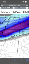
17Z RAP

W
WSW
Guest
Yeah it seems warmer there than i would have thought.Will tell you it’s much warmer today than yesterday in the Gatlinburg area. I don’t know how much that might hinder totals down to road.

Brad Travis on his update YouTube basically said NAM has been off for the last six months. So he disregards it.
I would worry about that then. This is when the NAM spits in your face.
W
WSW
Guest
Dewpoints have been falling since this morning in NW VA.

Precip breaking out in Mississippi and westward. Let the games begin!!
W
WSW
Guest
It's on! Good Luck to you guys!Precip breaking out in Mississippi and westward. Let the games begin!!View attachment 142250
I will post pictures of things here for everyone.It's on! Good Luck to you guys!
Storm5
Member
Confirmed reports that flurries are reaching the ground already in northern Mississippi
Brent
Member
Really coming down now
Getting a nice break out in Mississippi now. 
Triplephase93
Member
Chattanooga up to 47. Forecasted high was 43.
ghost1
Member
Driving through NW MS beginning to see some small flakes falling
severestorm
Member
Currently, near 50 with a DP of 31. Dusting at best for Asheville. Expecting rain.
EMTime
Member
I can confirm it's sleeting here in Lee County ms. Lite sleet.
Last edited:
The cold has really been hung up behind the Cumberland Plateau.Driving through NW MS beginning to see some small flakes falling
Brent
Member


BillyMurrayWx
Member
Always a concern for places like Chattanooga, Cleveland, and northwest Georgia when trying to get winter weather.The cold has really been hung up behind the Cumberland Plateau.
LukeBarrette
im north of 90% of people on here so yeah
Meteorology Student
Member
2024 Supporter
2017-2023 Supporter
Radar looks great right now in the mid south
JLL1973
Member
Some hope for the n nc folks per latest hrrr

severestorm
Member
Current temps:

NWMSGuy
Member
Can confirm it’s snowing in Tate County, MS!
Just issued!
Winter Weather Advisory is in effect for Siloam, NC 27047 until Tuesday at 7:00 AM EST. More info: http://wx4.us/sewx/pRrXc
Sent from my iPhone using Tapatalk
Winter Weather Advisory is in effect for Siloam, NC 27047 until Tuesday at 7:00 AM EST. More info: http://wx4.us/sewx/pRrXc
Sent from my iPhone using Tapatalk
accu35
Member
Actually precipitation over North MS is on schedule according to the modelsmodels are pretty much useless now. Interesting precipitation is breaking out earlier than model guidance. Regardless of what happens they have been horrible. Literally trended in opposite direction.
Triplephase93
Member
Also interesting the globals had this south of most of the res models.
Bang! I don’t root for many on here but I always root for BigFrosty. Go get emJust issued!
Winter Weather Advisory is in effect for Siloam, NC 27047 until Tuesday at 7:00 AM EST. More info: http://wx4.us/sewx/pRrXc
Sent from my iPhone using Tapatalk
accu35
Member
I can confirm it’s sun shining @ 59 degrees
Ron Burgundy
Member
I’ll say. 56 here right now. I guess I should enjoy a nice day but I’m too busy seething with envy.The cold has really been hung up behind the Cumberland Plateau.
Triplephase93
Member

PARSONBROWN
Member
Not worried. Just relaying what the man saidI would worry about that then. This is when the NAM spits in your face.
FFC expanded the WWA slightly. Pickens Co to the east and down to Haralson Co to the south. A little surprised … must be expecting a little more freezing rain.
StormStalker
Member
Snowing here in Florence (AL)
W
WSW
Guest
Has really upped the totals for the Shenandoah Valley.