I don't remember ever seeing a setup like this. Storm in TN that just does nothing in NC and for the most part not a whole lot in VA... just a strange storm no?
-
Hello, please take a minute to check out our awesome content, contributed by the wonderful members of our community. We hope you'll add your own thoughts and opinions by making a free account!
You are using an out of date browser. It may not display this or other websites correctly.
You should upgrade or use an alternative browser.
You should upgrade or use an alternative browser.
Wintry January 14-16th storm potential.
- Thread starter TheBatman
- Start date
W
WSW
Guest
Models have been trending upward for Virginia.I don't remember ever seeing a setup like this. Storm in TN that just does nothing in NC and for the most part not a whole lot in VA... just a strange storm no?

W
WSW
Guest
.png")
W
WSW
Guest
.png")
LukeBarrette
im north of 90% of people on here so yeah
Meteorology Student
Member
2024 Supporter
2017-2023 Supporter
I don’t think the RAP understands that downsloping exists
W
WSW
Guest
Haha maybe not, but the GFS and NAM have definitely trended better tonight. Both show 2-4 for NVA and DC metro.I don’t think the RAP understands that downsloping exists
What is the most accurate/trusted model for placement of 700mb UVVs at a lead time of 36-48 hours? If I was making a snowfall forecast, that model would be the hill I would stand on.
UK south a tick, and a tad drier.
Stormlover
Member

SnowwxAtl
Member
Is there a low pressure in the gulf from Euro at HR 60? ???Euro has been locked in!
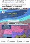
FFC has pulled the trigger on Winter Storm Warnings for the metro Chattanooga counties in north GA (Dade, Walker, Catoosa).
WInter Weather Advisories also out to the south and east of there, down to about a Rome to Blairsville line.

WInter Weather Advisories also out to the south and east of there, down to about a Rome to Blairsville line.
SimeonNC
Member
06z 12k and 3k NAM is south with the initial finger of snow. Maybe NC has a chance idk
SimeonNC
Member

3k NAM has way more precip in Alabama and Eastern NC
Nerman
Member
It was showing the system as a suppressed sheered out mess a couple days ago. It's seems to be locked on now with the other globals.Euro has been locked in!
Last edited:
PARSONBROWN
Member
Winter Storm Warning
URGENT - WINTER WEATHER MESSAGENational Weather Service Huntsville AL
240 AM CST Sun Jan 14 2024
ALZ001>006-009-TNZ076-096-097-142100-
/O.UPG.KHUN.WS.A.0001.240115T0600Z-240116T1200Z/
/O.NEW.KHUN.WS.W.0001.240115T0600Z-240116T1200Z/
Lauderdale-Colbert-Franklin AL-Lawrence-Limestone-Madison-Jackson-
Moore-Lincoln-Franklin TN-
Including the cities of Florence, Muscle Shoals, Sheffield,
Tuscumbia, Russellville, Red Bay, Moulton, Town Creek, Athens,
Huntsville, Scottsboro, Lynchburg, Fayetteville, Winchester,
Sewanee, Decherd, Estill Springs, and Cowan
240 AM CST Sun Jan 14 2024
...WINTER STORM WARNING IN EFFECT FROM MIDNIGHT TONIGHT TO 6 AM
CST TUESDAY...
* WHAT...Heavy snow expected. Total snow accumulations of 2 to 5
inches.
* WHERE...In Alabama, Lauderdale, Colbert, Franklin AL,
Lawrence, Limestone, Madison and Jackson counties. In
Tennessee, Moore, Lincoln and Franklin TN counties.
* WHEN...From midnight tonight to 6 AM CST Tuesday.
* IMPACTS...Travel could be very difficult. The hazardous
conditions could impact the morning or evening commute. The cold
wind chills as low as zero could result in hypothermia if
precautions are not taken.
PRECAUTIONARY/PREPAREDNESS ACTIONS...
If you must travel, keep an extra flashlight, food, and water in
your vehicle in case of an emergency.
NCHighCountryWX
Member
- Joined
- Dec 28, 2016
- Messages
- 700
- Reaction score
- 1,921


 Official guidance
EMTime
Member
Hello. Nws mem has 1-3 for me tonight, and 3-5 for tomorrow. I'm near tupelo Ms.
SnowWhite
Member
NCHighCountryWX
Member
- Joined
- Dec 28, 2016
- Messages
- 700
- Reaction score
- 1,921
 Official guidance ….
The entire state of Tennessee is under a WSW
EMTime
Member
There is a very thin swath in north ms that "could/may" get 12".
I'm 52, the most I've ever seen here at one time was 10".
I'm 52, the most I've ever seen here at one time was 10".

Nomanslandva
Member
I agree, this is an odd setup. Triad and north may do very well with this though.I don't remember ever seeing a setup like this. Storm in TN that just does nothing in NC and for the most part not a whole lot in VA... just a strange storm no?
Nomanslandva
Member
Well, now that HRRR has continued to trend south overnight, it seems to look better east of the mountains. Will check on NAMs and RGEM after church. ?Yea, I don't think the RAP is sophisticated enough to realize downsloping is going to kill gpf down here in the valley. I hope I am wrong and we get a few inches but not excited about things as they are right this second.
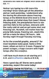
Tupelo avg less than 1" snow per season and they looking at 5". This is a fairly historic event for parts of the deep south.
High temps don't get above 30F for several days.
And to think NYC been 2 years since it's seen 1" of snow...unreal.

High temps don't get above 30F for several days.
And to think NYC been 2 years since it's seen 1" of snow...unreal.
For me, just outside the edge. Rooting for our other peeps … looks like a cool storm for many.
On the FFC forecast discussion below I think where you see NE should be NW. (Not meant to sound like a criticism … The FFC folks do a great job!)
FXUS62 KFFC 141136
AFDFFC
Area Forecast Discussion
National Weather Service Peachtree City GA
636 AM EST Sun Jan 14 2024
...New 12Z Aviation Discussion...
.SHORT TERM...
(Today through Monday)
Issued at 425 AM EST Sun Jan 14 2024
The important parts:
-Dry and pleasant today!
-Winter Weather is set to push into the are on Monday night and into
Tuesday. A Winter Storm Warning has been issued for NE GA with a
Winter Weather Advisory for the remainder of N GA.
A pleasant mid winter day is on tap for us this afternoon. Mostly
clear skies and dry conditions will make it an ideal day to spend
outside. Winds will be out of the NW at generally less than 8
mph. Overnight lows will be around freezing for much of the CWA.
Tomorrow starts out in much the same way out ahead of a weak trough
in the upper level flow. Highs will be in the low to mid 50s for
much of the day, but temps are expected to drop in the late
afternoon and early evening. Precip changes begin to increase after
10 AM and as cold air pushes in we`ll begin to see a transition from
rain to a wintry mix across most of northern GA with snow and ice
in NE Georgia.
A Winter Storm Warning will go into effect tomorrow at 7AM and run
until 7AM Tuesday. During that time, portions of NE Georgia could
see in excess of two inches of snow and up to a tenth of an inch of
ice.
A Winter Weather Advisory will run during the same time period for
the rest of northern Georgia where new snow totals should be around
an inch or less with the chance for a hundredth of an inch of
ice. A few pockets of heavier snow are possible in the advisory;
especially across the areas of highest elevation. Please continue
to monitor the forecast closely as snow and ice totals are subject
to change as the event gets closer.
Vaughn
WEATHERBOYROY
Member
I know it could change fast, but I'm not impressed with the southern feed in southeast Texas, which should be showing up on radar by now satellite imagery seems to show a weaker flow than I expected. maybe the system is just a little slower than forecast?
satellite imagery seems to show a weaker flow than I expected. maybe the system is just a little slower than forecast?LukeBarrette
im north of 90% of people on here so yeah
Meteorology Student
Member
2024 Supporter
2017-2023 Supporter
HRRR doesn’t show it yet. I think you’ll be fineI know it could change fast, but I'm not impressed with the southern feed in southeast Texas, which should be showing up on radar by now
WEATHERBOYROY
Member
good deal, I was looking at 3k NAMHRRR doesn’t show it yet. I think you’ll be fine
rburrel2
Member
Things seem to be trending really good for big frosty land in NC. rgem, gfs, euro, arw, all show accumulating snow there. the arw was especially bullish.
It's becoming clear the SW NC mountains are going to be the jackpot for the storm.

It's becoming clear the SW NC mountains are going to be the jackpot for the storm.
Nerman
Member
Pretty wild that Chattanooga where my sister lives gets a high of 34 on Monday while Kennesaw, GA where my mom lives is in the mid 50s. I'm sure it's happened before but I don't remember seeing it.


JLL1973
Member
Reminder in areas like AL, MS, check that DGZ saturation. The 3KM NAM is quite dry for a lot of locations even though it's showing "snow" on the precipitation type maps.
Edit: What this means is you need moisture in the area of the atmosphere that snowflakes form.
Edit: What this means is you need moisture in the area of the atmosphere that snowflakes form.
- Joined
- Jan 2, 2017
- Messages
- 1,566
- Reaction score
- 4,279
Yea I feel like those areas aren't used to virga storms may be sadly let down in this instance. Hopefully not I'm rooting for them sitting on the dry side here.Reminder in areas like AL, MS, check that DGZ saturation. The 3KM NAM is quite dry for a lot of locations even though it's showing "snow" on the precipitation type maps.
Edit: What this means is you need moisture in the area of the atmosphere that snowflakes form.
W
WSW
Guest
Nice system from northern MS to Maryland
.png")
StormStalker
Member
Yeah, hoping things still come together nicely for a majority of us.HRRR doesn’t show it yet. I think you’ll be fine
Things seem to be trending really good for big frosty land in NC. rgem, gfs, euro, arw, all show accumulating snow there. the arw was especially bullish.
It's becoming clear the SW NC mountains are going to be the jackpot for the storm.
View attachment 142202
RNK says pretty much nada for frosty land. Lol

Sent from my iPhone using Tapatalk
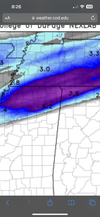
HRRR 3K 12Z RUN
I live at the lower green dot and work at the upper
Will be working Monday night and Tuesday night
I live at the lower green dot and work at the upper
Will be working Monday night and Tuesday night
rburrel2
Member
really nasty trend on the GFS for Mississippi. Congrats Virginia?
