-
Hello, please take a minute to check out our awesome content, contributed by the wonderful members of our community. We hope you'll add your own thoughts and opinions by making a free account!
You are using an out of date browser. It may not display this or other websites correctly.
You should upgrade or use an alternative browser.
You should upgrade or use an alternative browser.
Wintry January 14-16th storm potential.
- Thread starter TheBatman
- Start date

Flotown
Member
boy that shows moving in here tomorrow evening right?in northwest al that is
- Joined
- Jan 23, 2021
- Messages
- 4,603
- Reaction score
- 15,199
- Location
- Lebanon Township, Durham County NC
@BIG FROSTY got almost 4” that HRRR run
Man that precip band with just a brutal sharp cutoff for us in clt
W
WSW
Guest

Cad Wedge NC
Member
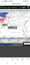
Yes, there was a clear jump south from the 18z run.Compared to 18Z it's further south.
View attachment 142121
thanksgivingbrown
Member
Is it just me or has the HRRR had an uptick in totals for North Alabama
LukeBarrette
im north of 90% of people on here so yeah
Meteorology Student
Member
2024 Supporter
2017-2023 Supporter

Very impressive HRRR run for western VA. Starts lightly snowing early monday and continues all the way till late monday and probably longer (run ended). So close for NC folks.
W
WSW
Guest
.png")
ChattaVOL
Member
I want the HRRR to come a tad more south and I’ll feel good about Chattanooga.
Sent from my iPhone using Tapatalk
Sent from my iPhone using Tapatalk
- Joined
- Jan 23, 2021
- Messages
- 4,603
- Reaction score
- 15,199
- Location
- Lebanon Township, Durham County NC
I wouldn’t get too high or too low with where modeling shows this finger of precip. We all know in these overrunning situations they can be fickle


W
WSW
Guest
Yeah, and if you finish the run it brings snow to Northern Va and DC metro.
Blue_Ridge_Escarpment
Member
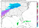
Agree. NAM south early on. We’ll see if it translates18z and 00z at 21z Sunday... Its early but this so far looks a jog south.
View attachment 142129
View attachment 142128
1” Ice storm 4 u
Member
Looking at the HRRR surface temps are horrible it barely goes below freezing just above the triad and then rises into the 40’s during the afternoon. Outside of the mountains and extreme nw NC this is basically a non event. anything that does fall will quickly melt. Hopefully people in the triad can see some flakes regardless.
Blue_Ridge_Escarpment
Member
Don’t take the HRRR surface temps literal at this range. Known warm bias at this lead.Looking at the HRRR surface temps are horrible it barely goes below freezing just above the triad and then rises into the 40’s during the afternoon. Outside of the mountains and extreme nw NC this is basically a non event. anything that does fall will quickly melt.
Storm5
Member
No point in arguing north or south IMO we all know there are gonna be placement swings . There hasn’t been a huge shift either way.
Mountains just kill us damnit

PARSONBROWN
Member
well said storm
Yup. can and will be fickle for sure!I wouldn’t get too high or too low with where modeling shows this finger of precip. We all know in these overrunning situations they can be fickle
Storm5
Member
00z nam looks very similar to 18z
We absolutely suck in nc

Blue_Ridge_Escarpment
Member
Honestly, Pretty substantial south shift at this lead00z nam looks very similar to 18z
Had better tilt that run and more consolidation

Storm5
Member
Let’s see if 00z pops the second area of precip in southern miss and Alabama
Usmeagle2005
Member
I’ll be happy with another 40 miles shift. Baby steps, but we don’t have too many steps left.?Honestly, Pretty substantial south shift at this lead
Blue_Ridge_Escarpment
Member
FWIW, 0Z hi-res GFS appears quite a bit south of its previous run.
Nomanslandva
Member
NAM is tick south. What an odd system. HRRR had hours of SN but like .1 gpf. we'll see I guess.
He's referring to the FV3 hi-res.GFS isn't out yet, what am I missing? And high res GFS?
Blue_Ridge_Escarpment
Member
It runs at 12Z and 00Z. It’s “FV3” on Tropical Tidbits.GFS isn't out yet, what am I missing? And high res GFS?
???????

Storm5
Member

I’ll take what the NAM is smoking

Man thats alot IP and Frz Rain thru parts of central AL and parts of GAView attachment 142136
I’ll take what the NAM is smoking
Stormlover
Member
that map has sleet and freezing rain as snow, right?View attachment 142136
I’ll take what the NAM is smoking
Can we get a round two?

Man this sucks doesnt need much more here (13).png")