CNCsnwfan1210
Member
GFS with the bloomer again

Sent from my SM-A136U1 using Tapatalk

Sent from my SM-A136U1 using Tapatalk
So that's from the low off the coast?GFS with the bloomer again
Sent from my SM-A136U1 using Tapatalk

This thing is drying up on the models pretty quickly it would seem. I’m guessing the further south it is shunted, the tilt and dynamics become less favorable. Puts my in a better position for snow in Chattanooga. Overrunning is notoriously under-modeled precip wise a lot of the time so I’m very interested to actually watch this one play out. Nowcast should be fun with this one lol
I-20 corridor in Alabama could be caught off guard if this thing shifts south at the last minute. What a close call..GFS is further south in GA
View attachment 141987
OkLooks like a dud for NC. At least it will be dry if we don't get any snow. Rather have that than more rain.

Combination of the tilted trough and the offshore low that developed st the last minute is my guess.So that's from the low off the coast?
This is true... overrunning events always do good for us.. just getting in the band is keyThis thing is drying up on the models pretty quickly it would seem. I’m guessing the further south it is shunted, the tilt and dynamics become less favorable. Puts my in a better position for snow in Chattanooga. Overrunning is notoriously under-modeled precip wise a lot of the time so I’m very interested to actually watch this one play out. Nowcast should be fun with this one lol
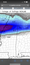
What are your thoughts on this continued suppression south of the snow band over TN/AL?I am almost 100% sure the reason that finger of snow is trending south is related to models being to weak with the TPV over the northern plains/Montana until go time, and it’s starting to translate. Remember, that moves east and suppresses the height field. So it makes sense things are going south, because it’s stronger at go time then what models have View attachment 141996


Globals have been struggling with this the last 2 days. Initializing to weak. Id say if it continues, it’s possible it continues to trend south, but the jumps overall probably slow down Quickly soonWhat are your thoughts on this continued suppression south of the snow band over TN/AL?
I spoke too soon.
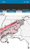
Highly unlikely that every single model, including all of their Ensemble members are missing the snow that bad. If anything, maybe hwy 278 gets caught off guard in the eastern parts of ALI-20 corridor in Alabama could be caught off guard if this thing shifts south at the last minute. What a close call..
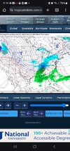
Interesting considering it did the same thing as the GFS with the Montana TPV, it has been struggling far worse with it. looks like more western Atlantic ridge that cmc runCMC ticked north lol
View attachment 142000
Cmc always has a north biasCMC ticked north lol
View attachment 142000

1-20 is gonna be freezing rain . If you want snow gotta go northHighly unlikely that every single model, including all of their Ensemble members are missing the snow that bad. If anything, maybe hwy 278 gets caught off guard in the eastern parts of AL
I believe we hit the southern limit.. they will adjust north slightlyGlobals have been struggling with this the last 2 days. Initializing to weak. Id say if it continues, it’s possible it continues to trend south, but the jumps overall probably slow down Quickly soon
100%1-20 is gonna be freezing rain . If you want snow gotta go north
Dang that is ugly. CMC is definitely bringing the moisture/precip.Cmc ZR
Check out the snow in the moderating thread when you have a sec1-20 is gonna be freezing rain . If you want snow gotta go north
Like where you and I are.Feels like the money for NC is in being far enough north and west for the original band yet east enough for the late band
Not really that close for snow… maybe some light pingers and a little ZRI-20 corridor in Alabama could be caught off guard if this thing shifts south at the last minute. What a close call..
Sleet and freezing rain are very much a concern all the way into that area. just one model:Highly unlikely that every single model, including all of their Ensemble members are missing the snow that bad. If anything, maybe hwy 278 gets caught off guard in the eastern parts of AL


Not really that close for snow… maybe some light pingers and a little ZR