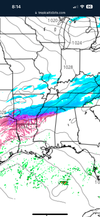
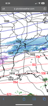
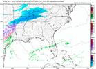
• Hello, please take a minute to check out our awesome content, contributed by the wonderful members of our community. We hope you'll add your own thoughts and opinions by making a free account!

Wintry January 14-16th storm potential.

Ha, I've been saying the opposite. I want the ridge to rollover in SW Canada to give us a little more positive tilt on the trough, then have it yank to neutral just in time. If not, we get the inland solution of the UKMet. Also, the Euro has more press southeast with the heights thru Ohio and PA, so both are factors. Mid-South areas will want the UKMet solution
My mental pic Im drawing is like the 12z GFS. I hear you though. Wanted the SW back out over the pacific

gfs_z500a_namer_21.png
 
Ha, I've been saying the opposite. I want the ridge to rollover in SW Canada to give us a little more positive tilt on the trough, then have it yank to neutral just in time. If not, we get the inland solution of the UKMet. Also, the Euro has more press southeast with the heights thru Ohio and PA, so both are factors. Mid-South areas will want the UKMet solution

VmhZHAD.gif


WqYRFcB.png

I'm confused with how the UK is giving us an inland solution. I thought a cutter, amped or not, was pretty much off the table because of the massive block that will be in place and the LP that will be in front of the system in the NE. I guess maybe the UKMET is placing the LP too far North to prevent the storm from cutting.
 
Last edited:
I mentioned this previously, but you can thank the block for that. I would like for everyone reading this board to just step back, take a deep breath, and behold a true, west-based NAO block. We've gone years and years without seeing this. I think we should pause for a moment to enjoy.

So many winters, we just hope and pray for a little ridging up there somewhere. A block like this is not going to be quick to break down and move out. It's good to remember that, because as long as it's there and of that magnitude, things in the modeling are going to have more of a tendency to press south than they usually do, as we move in closer...up to a point, at least.

View attachment 141481
I remember Matthew East talking a lot about this exact look back in the winter of 2009-10. Anytime the largest heights are set up over Baffin Bay, he said was the best for Carolina winter storms
 
Back
Top