Storm5
Member
These cmc totals are gonna be nuts . It’s trying to really crank. Gfs had 10 hours plus of snow in Huntsville, cmc is gonna have even longer
So which model do you believe?? Heck it almost like pick the model showing the most in your backyard. lolGfs gonna have some fat totals for Huntsville


Will this make the precip trend further south for the western areas of the southeast?Another trend I'm noticing in all guidance is the core of the TPV is trending south each run. This probably partly responsible for some of the south trends seen overall, but could also really change things for further east areas if this could continue.
View attachment 141897
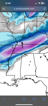
 CMC ice

I don’t know how many times…also not to be a buzzkill but if you're in MS/AL and the nam spit out sleet for you, and you think it's overdoing things... i feel like this meme
seen a lot of forecasts go sour from people not respecting the nam's thermals
IMO - if this trend continues then more south trends overall will continue.Will this make the precip trend further south for the western areas of the southeast?
That would be lights out
Dang, it amazing with the swath of snow that the GFS and CMC has. Almost identical.These cmc totals are gonna be nuts . It’s trying to really crank. Gfs had 10 hours plus of snow in Huntsville, cmc is gonna have even longer

I could that being a possibility considering this is an arctic airmass that’s coming in.
I honestly think a blend wouldn’t be a bad idea at the moment. Even with a more positive tilt trough the gfs you would think the gfs would still have a larger precip field like the rgem and cmc have. But not apples to apples at H5 . Still being 54 hours plus out so much can go wrong lol . So get out your lucky coin , flip it and call heads or tailsSo which model do you believe?? Heck it almost like pick the model showing the most in your backyard. lol
I figure Huntsville will be putting most of North Alabama of winter storm watches in their morning package.
Starting tomorrow 12z some of the short range models will be coming in good range and will see what happens.
That’s the thing just a little more tilt and it’s a bigger deal for 80 percent of the boardModels really elongating the energy, which is a right direction for areas east, now add the cherry on top and tilt it
Yea I just thinking the same thing. Kinda strange on how narrow that precip field is. You usually don’t see that much.I honestly think a blend wouldn’t be a bad idea at the moment. Even with a more positive tilt trough the gfs you would think the gfs would still have a larger precip field like the rgem and cmc have. But not apples to apples at H5 . Still being 54 hours plus out so much can go wrong lol . So get out your lucky coin , flip it and call heads or tails
Got 2 1/2 days to make it happen. Point of no return would probably be 12z runs Sunday.That’s the thing just a little more tilt and it’s a bigger deal for 80 percent of the board

Another version of what has already been posted, but south trend with initial precip band and colder in recent runs. Arctic air doing its thang I guessAnother trend I'm noticing in all guidance is the core of the TPV is trending south each run. This probably partly responsible for some of the south trends seen overall, but could also really change things for further east areas if this could continue.
View attachment 141897
View attachment 141898


 ??. I don’t think would have said that on air. Of course he said the track so go further north or south.

As an EMS worker I hear you brother! Amen! Light rain is enough for 10 overturns to go out and wipe out all ambulances and keep us running our tails off all night! Tell em!YALL CAN KEEP THE SNOW AND ICE.. I WORK IN PUBLIC SAFETY AND AT A 9-1-1 DISPATCH CENTER. PEOPLE CANT DRIVE WHEN IT'S DRY AND THE'RE ALL WANTING SNOW.. ILL HAVE TO WORK 9-1-1 WHEN THIS IS HAPPENING AND IF THE FZR VERIFIES THEN ILL BE SPENDING MONDAY AND TUESDAY AT WORK THEN POSS MY OFF DAYS WEDNESDAY AND THURSDAY HERE...
Yes it looks in line with GFS. About a 25 mile shift south vs the 18z GEFS.Gefs snow meanView attachment 141914
That’s the 12z cmc ensembles


It actually went a little southUkmet is north of other guidance
Grit - do you think this trend will continue and that initial band will keep trending south? Not sure if you have any thoughts on the cold pressAnother version of what has already been posted, but south trend with initial precip band and colder in recent runs. Arctic air doing its thang I guess
Feeling really good for bigUkmet is north of other guidance