SimeonNC
Member
This is gonna sound weird but I wonder if the warm gulf will affect precip for those in the Mid-South. Whether it be more qpf or more of a warm-nose or both
Yes it’s a weenie statement but it’s also true. I mean was just saw it happen two years ago in about half the time we’re at now.It’s the weenie in me I know BUT we have come back from worse with less lead time so I’ll keep a sliver of hope
Hm true, always screwed me in Raleigh w 850s but wonder if it can help those folks w more expansive precipThis is gonna sound weird but I wonder if the warm gulf will affect precip for those in the Mid-South. Whether it be more qpf or more of a warm-nose or both
Good chance at iceIs there anything showing hope of over performing possibilities for central AL(I-20 south) or is this just not the one.
I do think a lot of us south of northern AL, northern MS, TN, and AR will have an ice event. Maybe some of us will get some sleet to mix in to. But it's just not a deep south snow event, unfortunately.Is there anything showing hope of over performing possibilities for central AL(I-20 south) or is this just not the one.
Interesting that the NAM has snow that far northTorturing myself at this point
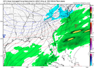
View attachment 141848
Is it digging more. So what does that mean on the surface??View attachment 141851
Lololol the NAM is digging more this run.
That the euro is king.Is it digging more. So what does that mean on the surface??
One sliver of hope is all those years droughts ended in late January or February. But that is just pathetic imo to go that long without even a trace.From Brad p. Unreal
View attachment 141850
Just wow
good for far nwest bama?That the euro is king.
Seriously though its a tough look for your guys slightly more WAA and the best fgen potentially getting tucked right against the TN/Al/ms border
There's a lot of WAA aloft I'm afraid that a lot of you guys in Bama are sleet/freezing rain that might end as a little snow especially north and westgood for far nwest bama?
oh well maybe nam being nam...lets see what other guidance saysThere's a lot of WAA aloft I'm afraid that a lot of it guys in Bama are sleet/freezing rain that might end as a little snow especially north and west
am i right in saying nam tends to overdo waa??There's a lot of WAA aloft I'm afraid that a lot of it guys in Bama are sleet/freezing rain that might end as a little snow especially north and west
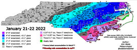
So similar to jan 2022, having to rely on tilting energy to throw precip back west
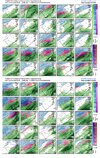
View attachment 141858View attachment 141860
View attachment 141857View attachment 141855

Can’t remember how did the models look this far out then? Cant remember if they ever showed a hit and backed off or if it was slight adjustments to go timeSo similar to jan 2022, having to rely on tilting energy to throw precip back west
View attachment 141858View attachment 141860
View attachment 141857View attachment 141855
If it's warmer aloft versus the rest it's usually a red flag that it might be on to something but it does have a tendency to over amp/overdo waaam i right in saying nam tends to overdo waa??
Went from weenie runs, to suppression under 100, to runs showing nothing except for freezing drizzle back on the coast, back to a solid snow event under 48. Biggest flop ever from the NAM and HRRR. @jackendrickwx has the nam trend gif when it came backCan’t remember how did the models look this far out then? Cant remember if they ever showed a hit and backed off or if it was slight adjustments to go time
thanksIf it's warmer aloft versus the rest it's usually a red flag that it might be on to something but it does have a tendency to over amp/overdo waa
Yea I think literally the day before I had no hope for us in clt and then the hrrr started a massive shiftWent from weenie runs, to suppression under 100, to runs showing nothing except for freezing drizzle back on the coast, back to a solid snow event under 48. Biggest flop ever from the NAM and HRRR. @jackendrickwx has the nam trend gif when it came back
It was a storm that was just basically going to be for coastal sections only until about 36 hours before the stormCan’t remember how did the models look this far out then? Cant remember if they ever showed a hit and backed off or if it was slight adjustments to go time
NAM was the first model to show an all ZR event here last weekend. Agree, it over amps sometimes but the warning shots can't be totally ignored.If it's warmer aloft versus the rest it's usually a red flag that it might be on to something but it does have a tendency to over amp/overdo waa
Arctic is often very shallow. I was on a business trip to Denver one time and the temperature in town was near zero while at the ski resorts at higher elevations just to the west, it was in the lower 30sI’m not buying zr/ip as precip type here in AL. Too much arctic air rushing south.
Sent from my iPhone using Tapatalk
That and the cold can't get over the pass. I've experienced the same thing, 25 in Breck, drove down to Denver and it was 8. It was bizarre.Arctic is often very shallow. I was on a business trip to Denver one time and the temperature in town was near zero while at the ski resorts at higher elevations just to the west, it was in the lower 30s
Fantastic storm in the upstateSo similar to jan 2022, having to rely on tilting energy to throw precip back west
View attachment 141858View attachment 141860
View attachment 141857View attachment 141855


