accu35
Member
Yes very possible.so ice, freezing rain in the picture for central Alabama ?
Yes very possible.so ice, freezing rain in the picture for central Alabama ?
was this Snowmageddon of 2014 ?I would be willing to wager a bunch a Mets are crapping bricks right now. This one is giving off huge January 2014 vibes. I will leave everyone with this nugget of wisdom. Even if the precip is light "those who fail to learn from history are doomed to repeat it"
I’m gonna look at the short ranges.For Alabama and B'ham area, expect the forecast to change up until Sunday or Monday when the models have better data?
Northwest trend?Sickening how close
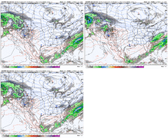
View attachment 141794
It’s not really a NW trend that we need based on the EURO and GFS… we need that to go neutral and then negative tilt few hours earlier so that it pulls moisture inland over the CarolinasNorthwest trend?
Something that won’t be known until the wave is on land and honestly probably not until 24-36 hours out from us out here also. It’s a wait and see game at this pointIt’s not really a NW trend that we need based on the EURO and GFS… we need that to go neutral and then negative tilt few hours earlier so that it pulls moisture inland over the Carolinas

Very true. It reminds a little but of the 1/21-22/2022 storm that the models didn’t start catching on to the tilt of the trough until about 48 hours or so out.Something that won’t be known until the wave is on land and honestly probably not until 24-36 hours out from us out here also. It’s a wait and see game at this point
Not everyone ?
At least it's not just here..... it's the entire multi-state area.24 hours GEFS mean trending drier.
View attachment 141809
This tweet is interesting and echoes your statement.Something that won’t be known until the wave is on land and honestly probably not until 24-36 hours out from us out here also. It’s a wait and see game at this point
This tweet is interesting and echoes your statement.
Yeah you might get some as it is pulling off the coast. Probably an inch or 2. Probably an inch or so up to DC/Baltimore as well.Not everyone ?
Don’t even worry about the NAM at that rangeWill be interesting to see how this plays out. The Canadian/EURO and GFS have a nice hit of Winter for Northwest MS. NAM 12K says, hold up! ?
View attachment 141813
Yeah I was wondering if it wasn’t truly in its wheelhouse of accuracy yet.Don’t even worry about the NAM at that range
I hope not here for sure. ??Yeah I was wondering if it wasn’t truly in its wheelhouse of accuracy yet.
One thing I noted is the cold 850 and surface temps. You wouldn’t likely need a whole lot to squeeze out something from the atmosphere.Continuing to see small gains at H5 for redevelopment over the east. Now seeing the beginning of the surface reflections to go with it on the 18z Euro control. It ain't much, but it's a start. Check out that Outer Banks swath...
View attachment 141824
View attachment 141823
Nope. Right at the tail end the 18z euro control really tried to get precip redevelopment going (thus that slightly enhanced swath along the coast line). Just a little bit more of the same and a 2-4 inch "spire-like" event would be on the table.One thing I noted is the cold 850 and surface temps. You wouldn’t likely need a whole lot to squeeze out something from the atmosphere.

It’s the weenie in me I know BUT we have come back from worse with less lead time so I’ll keep a sliver of hopeContinuing to see small gains at H5 for redevelopment over the east. Now seeing the beginning of the surface reflections to go with it on the 18z Euro control. It ain't much, but it's a start. Check out that Outer Banks swath...
View attachment 141824
View attachment 141823
That's for sure. This might be noise or it might be the beginning of a trend, time will tell.It’s the weenie in me I know BUT we have come back from worse with less lead time so I’ll keep a sliver of hope
Something is there for sure. Just need to see what enhances...or disappearsThat's for sure. This might be noise or it might be the beginning of a trend, time will tell.
