JLL1973
Member
ECMWF is also going to be a good hit for northern ms and midsouth areas
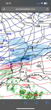
Strange because typically the 3k is slower with the cold pushNot only are dew points ridiculously different, but surface temps much colder as well on the 3km.View attachment 141736View attachment 141737
12z euro was close - it held positive tilt longer which allowed more of a cold press, then it almost made the turn. This is the only path for those in the RDU corridor.Euro is probably the closest best option because it still lags behind the second vort, after the first initial one, which people east in ATL/CLT/RAH want. But problem is getting a favorable tilt. And this euro run looks like it’s not going to get that done
No one sent me a copy of the memo that said we could start drankin'....but you aren't wrong.Euro is a buzz kill
.png")
Do you think the models are too less with QPF for the NC mountains? Weird the piedmont of TN jackpots while the mountains get nothing.12z euro was close - it held positive tilt longer which allowed more of a cold press, then it almost made the turn. This is the only path for those in the RDU corridor.


i don't disagree and this is a similar look to those dud NAM runs from that jan 2022 storm before the qpf kicked back up. a situation with a lot of leverage where small tweaks have big ramificationsIf the trough had began to tilt in the time frame below, all of that moisture along the coastal front would have been pulled inland. Regardless of how it ultimately ends, this is not over yet.
View attachment 141743
View attachment 141745

It was actually about 36 hours out with that January 2022 storm that we saw things adjust and more QPF getting pulled west. So certainly still time for things to change and personally I would definitely rather have the EURO where it is with the cold push.i don't disagree and this is a similar look to those dud NAM runs from that jan 2022 storm before the qpf kicked back up. a situation with a lot of leverage where small tweaks have big ramifications
on the other hand, i'll tell ya, when you get a model suite like this it begins to feel like a canoe taking on water quicker than you can bail it out
hope the ensembles show some promise
No doubt you would think watches would go up for much of their area by tonightAs some of the models are showing this storm moving into the Mid-South Sunday evening, I'm thinking we should start to see winter weather headlines out of Memphis overnight.
Agreed! Going to watch to see if they pull the trigger in their afternoon package.No doubt you would think watches would go up for much of their area by tonight

I can’t handle even a 20 mile jog to the north, I’m on the edge.Good luck to those west of the apps View attachment 141766
You’re in a good spot the main axis shifted south that run . Northern Mississippi looks greatI can’t handle even a 20 mile jog to the north, I’m on the edge.
I don’t even need to look at the models to see if snows coming to Nashville Monday. If there’s barely any new posts in the storm thread then I know we making snow angels soon ?Exactly. I think I can count on 2 hands the number of posting members this may effect (major snow) based on todays trends so far.
Don’t worry. I am going to be rooting for you on the next storm. This looks like an Interstate 20/59 north storm.Good luck to those west of the apps View attachment 141766
YesIs it still looking like icing possible south of the snow areas or does the map above include sleet/freezing rain?
I would love to see this shift about 50 miles south but I know that’s like pulling teeth in a world of NW trends. Nashville is golden in this set up it would seem.12z Canadian is a classic Miller A setup with low pressure tracking Panama City to Savannah to Wilmington. Total nuke job for TN. BUT...its only one run,

most likely in the morning sometimesAgreed! Going to watch to see if they pull the trigger in their afternoon package.

Here are the panelsAnyone have the EPS snow members available for us further west?


Does it have the ice map?
Thanks!