Mahomeless
Member
- Joined
- Oct 17, 2023
- Messages
- 900
- Reaction score
- 2,158
Maps?Canadian comes up through central Ga
Maps?Canadian comes up through central Ga

Don’t focus on one run.
Get on the board and then we focus on the rest of the season. According to the statistics, that is mission critical at this point.For us in Raleigh I would absolutely take this...we haven't seen a trace of snow in 2 years.
View attachment 141703
That's why i posted a four day trend.Don’t focus on one run.
Was that Canadian or gfs??Hard pass
Is that the GFS?Hard pass
CanadianWas that Canadian or gfs??
Storm been waiting on you to chime in. I been waiting on your intake on the winter weather.Hard pass
Looks ok for far NW AL
We haven't had one that bad since 1982... unfortunately we are overdue. Would be lights out for a few days!Hard pass

Honestly GEFS don't really seem to agree too much with Control run alot of members with snow and Ice thru AL/GA not as suppressed12z gefs looks more like a ice storm for Alabama. Good members

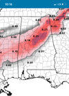
Our friend the northwest trendLooks great for TN and N MS, but not N AL, according to GFS four day accumulation trends.
To be clear, i'd love to see any flakes, but its the tease from earlier in the week.
View attachment 141702
Looks pretty good for TN, AR, northern MS and AL and not bad for western VA.Not starting the day off good for 95% of the board!

True. Seems most of the board lives in NC or GA.Exactly. I think I can count on 2 hands the number of posting members this may effect (major snow) based on todays trends so far.
This is not counting the ice which is further south
I hate to hear that....Do you happen to have any ZR/Sleet maps?This is not counting the ice which is further south

for real, do not understand the funeral vibes on here. i'm not as sanguine as last night but certainly don't feel shot down, and that's not a product of my latitude. a lot of the SE is in the running for a solid, "yearly climo" satisfying storm. still think there's potential for the carolinas (despite not great steps in this particular suite). not to mention we're still waiting on the euro's take


I figure the same five people every time must really enjoy throwing funerals ?for real, do not understand the funeral vibes on here. i'm not as sanguine as last night but certainly don't feel shot down, and that's not a product of my latitude. a lot of the SE is in the running for a solid, "yearly climo" satisfying storm. still think there's potential for the carolinas (despite not great steps in this particular suite). not to mention we're still waiting on the euro's take


For any chance of ice/sleet east of the mountains we're going to need the 3km NAM/hi-res GFS to be correct in their depictions at hr60.
The regular GFS and 12km NAM don't have that cold/dry air push.
The hi-res GFS is at 34/5 in my back yard at 7pm Sunday, the regular GFS is 38/18.


for real, do not understand the funeral vibes on here. i'm not as sanguine as last night but certainly don't feel shot down, and that's not a product of my latitude. a lot of the SE is in the running for a solid, "yearly climo" satisfying storm. still think there's potential for the carolinas (despite not great steps in this particular suite). not to mention we're still waiting on the euro's take!