Follow along with the video below to see how to install our site as a web app on your home screen.
Note: This feature may not be available in some browsers.
Hello, please take a minute to check out our awesome content, contributed by the wonderful members of our community. We hope you'll add your own thoughts and opinions by making a free account!
regarding "i would expect more precip from that!", i've thought that a lot too about trailing waves before. my thinking is that the lead "impulse" wave creates subsidence in its wake and CAA pulls in stabler air at the surface, so the trailing wave is fighting both of those things. it makes cyclogenesis harder since the boundary is further offshore and the lift generated from the trailing wave is fight an preceding airmass promoting sinking air
so the MS valley shortwave is fighting subsidence behind the NE wave
This site uses cookies to help personalise content, tailor your experience and to keep you logged in if you register.
By continuing to use this site, you are consenting to our use of cookies.
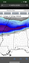
 Icon first ice map for south bama


 (11).png")