Stormlover
Member
Going to be a sweet spot just north of the rain/sleet/fr rain/rain line and it's looking more and more like far northwest and north central ala might be in it


was aboit to say...it still north of other guidance but south of its previous runIt actually went a little south
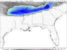
Don't have a strong opinion on it, but here on the CMC Ens, you can see here on the trend loop for Monday morning how the weak wave over OK is separating itself from the trailing wave over Montana. Also, the height lines change their orientation thru the SE and Mid-Atlantic (pointed farther south). So, these changes are moving the initial snow band south some and helping to crank some precip back inland with the trail wave diving down a little later and sharperGrit - do you think this trend will continue and that initial band will keep trending south? Not sure if you have any thoughts on the cold press

Lots of Chattanooga members here hoping to break our snow drought.
9 years since you’ve had a 6” snowfall is nothing. It’s been 41 years for Atlanta....
Yep. 22 months since we officially had a 1"+ snowfall, and 9 years since we had a 6"+ snowfall. Have to go back 13 years to find a snowpack that lingers for a whole week. Just sad lol. This setup has plenty of potential to overperform, BUT, plenty of potential to go poof. Always a game of chance.
We've had a few good snows here in the last 10 years but no staying power. 2 overnight thumpers, 1 in 2014, and 1 in 2015. They both melted off the next day. On February 8th in 2020, we picked up 3" under a ULL around 7am, and it was completely melted off by noon. Here are 2 pictures from the 2020 snow that stuck around for about 4 hours.Lots of Chattanooga members here hoping to break our snow drought.


Maybe that much ice is like the high wind forecast (70 mph) that never happens.


THEY JUST GAVE THE 3 COUNTIES A BIG MIDDLE FINGERLOL Huntsville you leave the 3 counties in white out and they should also be in the winter storm watch. Euro shifted south also with accumulation. Nam showing ice. Euro accumulation picture .View attachment 141933View attachment 141934
Yea can’t figure that out. Heck the Goofy (GFS) was definitely enough to put them in the watch too. Oh well, I sure they will include them on the midday guidanceTHEY JUST GAVE THE 3 COUNTIES A BIG MIDDLE FINGER
Such a tight gradientLOL Huntsville you leave the 3 counties in white out and they should also be in the winter storm watch. Euro shifted south also with accumulation. Nam showing ice. Euro accumulation picture .View attachment 141933View attachment 141934
Oh yea. It is definitely tight and I don’t see nothing set in stone until about 12 hours before the event.Such a tight gradient


I don’t think it’s really a south trend. It’s the tilt on the trough beginning to turn earlier and pulling the moisture back inland from the coastal low that’s getting going. By the time it’s showing that snow going over the Piedmont, the cold air is that and you can see that from the soundings as 850s are very supportive of snow. Certainly a good trend with the tilt of the trough and if it can back up just a tad sooner, this could be a bigger deal with more of NC and SC in playGFS with basically Winter Storm in portions of the Triad of NC & decent event for a chunk of NC. You can see the obvious South trend. I really wish that Arctic can over the Apps faster.
Well, I guess this still over 48 hours out from when precip would begin in the shafted counties, so they have plenty of time to add them later today or tonight if warranted.LOL Huntsville you leave the 3 counties in white out and they should also be in the winter storm watch. Euro shifted south also with accumulation. Nam showing ice. Euro accumulation picture .View attachment 141933View attachment 141934
Kuchera totals for day 4:Congrats Raleigh on the 06Z GFS! A nice 3 to 4 inch snowfall!

Honestly surprised those aren’t a bit higher back over CLT metro and the southern Piedmont. The radar depiction showed a solid 6+ hours of snowfall in those spots. Probably not great rates but falling overnight with temperatures mainly in the upper 20s it should have no trouble sticking. This could be a case where the surface output is still trying to catch up to the H5 changes

Very fickle setup. Type of setup that’s gonna be tough to nail down even at hour 48Just the slightest change in orientation of that trough from 0z to 06z GFS, made the difference in a few flurries to a couple of inches in C/ENC.
View attachment 141946
Yep and honestly I like where we (especially ENC) sit right now better than a coastal already along the coast. I mean too much digging, amplification and it can get pulled west quick too. Don't think there's time for that thoughVery fickle setup. Type of setup that’s gonna be tough to nail down even at hour 48