 Little more s with snow than 6z
-
Hello, please take a minute to check out our awesome content, contributed by the wonderful members of our community. We hope you'll add your own thoughts and opinions by making a free account!
You are using an out of date browser. It may not display this or other websites correctly.
You should upgrade or use an alternative browser.
You should upgrade or use an alternative browser.
Wintry January 14-16th storm potential.
- Thread starter TheBatman
- Start date
12z RGEM

buckinbronco
Member

WRF coming in further south with the initial finger of precip than other short range guidance…I know I’m grasping
iGRXY
Member

ICON is digging the energy further west and is stronger vs 6z
rburrel2
Member
Icon has a finger of light snow in the upstate Monday morning. Surface temps aren't great though. Possiblity of some mood flakes at least.
GFS and euro are showing more/less the exact same thing with that band barely making it far enough south and east to clip us Monday morning.
SW mountains are looking great for this front end hit now.
GFS and euro are showing more/less the exact same thing with that band barely making it far enough south and east to clip us Monday morning.
SW mountains are looking great for this front end hit now.

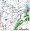
I can see this shifting another 50 miles south with the trends of all the models before go time.View attachment 141972Little more s with snow than 6z
Twister
Member
850s look iffy to meCold isn’t the issue
Sent from my SM-S911U using Tapatalk
I know I am going to keep wish casting for that southern trend.
I’m an EMT too so I hope people heed the warning and stay off the roads but it always goes the people who call are the first ones to argue with anything for the most part!As an EMS worker I hear you brother! Amen! Light rain is enough for 10 overturns to go out and wipe out all ambulances and keep us running our tails off all night! Tell em!
We could only dreamView attachment 141973
WRF coming in further south with the initial finger of precip than other short range guidance…I know I’m grasping
ChattaVOL
Member
Chattanooga could break the streak with this storm… but fully prepared to be heartbroken.
Sent from my iPhone using Tapatalk
Sent from my iPhone using Tapatalk
iGRXY
Member
850’s are an issue because the trough is too progressive not allowing for any lift to generate precip and slowing it down to allow more colder air to get in place. If the trough goes neutral tilt it will slow allowing the cold air to filter in and precip to drive dynamic cooling. The temps aren’t the issue here because they will be colder just from the slowing of the trough and precip being driven. Everything is dependent on a neutral tilted trough further west850s look iffy to me
Sent from my SM-S911U using Tapatalk
JLL1973
Member
NWMSGuy
Member
Should start seeing Warnings issued this afternoon/evening.Icon about same placement as 6Z and a little heavier precip. Northwest ms is probably gonna get dumped on.
Usmeagle2005
Member
It’s just weird how it shows between 23-27 here but rain.??Icon about same placement as 6Z and a little heavier precip. Northwest ms is probably gonna get dumped on.


JLL1973
Member
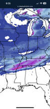
I think that model has surface product issues. If your in Tupelo that’s probably going to be snow or sleetIt’s just weird how it shows between 23-27 here but rain.??View attachment 141981View attachment 141982
WXinCanton
Member

WXinCanton
Member
NAM came in a tick north
On Pivotal, that rain in MS is sleet/freezing rain. TT doesn’t depict sleet/freezing as a separate thing for the ICON for some reason. It seems to classify that precip as “rain”.It’s just weird how it shows between 23-27 here but rain.??View attachment 141981View attachment 141982
Blue_Ridge_Escarpment
Member
On tropical tidbits the surface map only shows rain or snow. I believe the ICON on pivotal weather has snow, rain, and sleet/freezing rainIt’s just weird how it shows between 23-27 here but rain.??View attachment 141981View attachment 141982
Looks like a dud for NC. At least it will be dry if we don't get any snow. Rather have that than more rain.
NBAcentel
Member
GFS pushing WAA band way down into the Piedmont this run ?
Looks like a dud for NC. At least it will be dry if we don't get any snow. Rather have that than more rain.

A dud? The GFS looks even better for y’all & that’s BEFORE any low development.
Keep coming south baby

NWMSGuy
Member

GFS is further south in GA

Will be interesting to see which are right.. globals or hi rezGFS is further south in GA
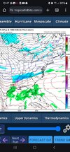
View attachment 141987
 I’m
I’m5 run trend

- Joined
- Jan 23, 2021
- Messages
- 4,603
- Reaction score
- 15,199
- Location
- Lebanon Township, Durham County NC
?

NBAcentel
Member


ForsythSnow
Moderator
All it needs to do is do this at least a couple more times and so many more of us would be in. A day ago and this was all the way in TN too, so fingers crossed this keeps sinking. It's all in the energy still offshore too.GFS is further south in GA
View attachment 141987
So if it keeps coming south is that going to hurt the low developing and brining in more precip off the coast?View attachment 141984
A dud? The GFS looks even better for y’all & that’s BEFORE any low development.
- Joined
- Jan 23, 2021
- Messages
- 4,603
- Reaction score
- 15,199
- Location
- Lebanon Township, Durham County NC
Boy that’s a big run for Murphy and Nantahala down in SW NC
Mahomeless
Member
- Joined
- Oct 17, 2023
- Messages
- 900
- Reaction score
- 2,158
So Globals holding serve (maybe shifted 20 miles south or so over the past few runs), but the short range HiRes models really moving this north....I know which basket im putting my eggs in.
GFS doing to me again
And not often we see a south trend. Usually we're hoping for a north trend off the coast.All it needs to do is do this at least a couple more times and so many more of us would be in. A day ago and this was all the way in TN too, so fingers crossed this keeps sinking. It's all in the energy still offshore too.