
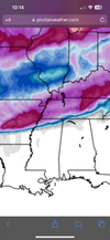
Just for anyone that wants to know, a lot of this ZR is *barely ZR by like the slimmest of margins and could easily be snow.
-
Hello, please take a minute to check out our awesome content, contributed by the wonderful members of our community. We hope you'll add your own thoughts and opinions by making a free account!
You are using an out of date browser. It may not display this or other websites correctly.
You should upgrade or use an alternative browser.
You should upgrade or use an alternative browser.
Wintry January 14-16th storm potential.
- Thread starter TheBatman
- Start date
That was good. Need a cigarette now and i dont smoke. Anyway, it can get better, a lot. And it can also head other direction. Fine line, jury is still out.
NBAcentel
Member
This sort of reminds me of the jan 2022 2nd weekend event, just without a stout wedge to introduce a lot more frozen precip 

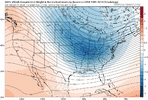
Diff in canadian verse gfs. Gfs tracks low across GOM, Canadian way inland. High stakes
accu35
Member

iGRXY
Member
CMC sends us a nice inland cutter and the only model remotely showing that which should tell you we got something to actually tract.
LukeBarrette
im north of 90% of people on here so yeah
Meteorology Student
Member
2024 Supporter
2017-2023 Supporter

LOL CMC
Interested in ukmet. Its been a 1000 miles away from all other guidance past 2 runs.CMC sends us a nice inland cutter and the only model remotely showing that which should tell you we got something to actually tract.
NBAcentel
Member


If you live in south Central AL through Atlanta. Take this run and run like you stole it. Probably a ZR glaze then a very respectable 2-4” snow event. Definitely would like to see the cooler trend continue because dang that is razors edge.
Blue_Ridge_Escarpment
Member
Did the UK hold that look at 0Z? Haven’t seen anything update for that product.CMC with a @SD tornado setup. Worth noting the UK isn’t far off ?View attachment 141600View attachment 141601
JLL1973
Member
iGRXY
Member
While the UK is respected, having the CMC as the only model on your side is not the hill a model wants to be onCMC with a @SD tornado setup. Worth noting the UK isn’t far off ?View attachment 141600View attachment 141601
Pretty much,yesDid the UK hold that look at 0Z? Haven’t seen anything update for that product.
accu35
Member

Anyone for round 2?
rburrel2
Member
Just to recap:
00z Icon is more/less a complete whiff with no storm
12z Euro was mostly a whiff as well.
00z GFS is a perfect track dream scenario.
00z Ukmet is a slightly inland tracking nuke job that's rain east of the apps.
00z CMC is close to an apps cutter with severe weather threat on the coastal plain.
place your bets?
Just to recap:
00z Icon is more/less a complete whiff with no storm
12z Euro was mostly a whiff as well.
00z GFS is a perfect track dream scenario.
00z Ukmet is a slightly inland tracking nuke job that's rain east of the apps.
00z CMC is close to an apps cutter with severe weather threat on the coastal plain.
place your bets?
Honestly based of the past years, my bet would have to be on a complete whiff/no storm at all.
Folks lets post about the rest of the systems in the January thread please or this is going to get really confusing
SimeonNC
Member
The 00z UK hasn't come out yet I think, at least not on pivotal. It's still the 12z
Stormlover
Member
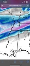
short range canadian, this is ONLY through 6am central monday

going to sounds really greedy
but i actually think there's a lot of room for improvement on the gfs. so far the trend hasn't stopped.
cmc i think is eating rocks. i don't think it digs the trough far enough and i think is fair to call an outlier
(also on the ukmet i've only ever viewed it from pivotal and members posting paysites that spit out weather maps that look like they were used in WWII. don't think it's out yet)
accu35
Member

These members looks like the Control/Eps earlier
accu35
Member
Man there are some nice gefs members out there
NBAcentel
Member
Love to see it ?? mean continues to go 

NorthGaWinter4
Member
GEFS looks great. Best look in a while.
0z Ukmet got on board with rest of model world. Wound up a good storm

Blue_Ridge_Escarpment
Member
Much colder run. Playing catchup
JLL1973
Member
Stormlover
Member
canadian ensemble chance of at least an inch

How much better could it get? I feel like it probably took everything it had to get to that point lol.That was good. Need a cigarette now and i dont smoke. Anyway, it can get better, a lot. And it can also head other direction. Fine line, jury is still out.
NBAcentel
Member
UKMeT taking giant leaps lol 

That's 12zcanadian ensemble chance of at least an inch
It came light years in that direction. We still need another bump. But atleast we get to swing the bat. If we whiff,we whiffMuch colder run. Playing catchup
NBAcentel
Member
UKMeT actually has an ice/sleet event for CAD regions now. Keeps trending significantly colder 


Stormlover
Member
Thanks. My bad. 0z is coming out nowThat's 12z
We are all on the line,barely inside line,just outside the line. Gonna see a lot of wobbeling all ops, ens, short range models for another day or 2. That 0Z gfs run I had 4-5, but less than hour drive due east was zilch. You notice the clown maps all have v shapes off to the NE. This shows you that they are all seeing a storm, forming, deepening. Just depends on timing, when,where it starts,track etc. 25 to 50 miles one way or the other, even with our block, NE features,changes everything a lot for your backyard.How much better could it get? I feel like it probably took everything it had to get to that point lol.
NBAcentel
Member
CMC ens ?
NBAcentel
Member
The CMC ens is way colder than it’s OP. Lots of UK looking members, with some CAD region ice events
LukeBarrette
im north of 90% of people on here so yeah
Meteorology Student
Member
2024 Supporter
2017-2023 Supporter
The CMC ens is way colder than it’s OP. Lots of UK looking members, with CAD region ice events

Stole this image but yes the OP is out to lunch