Shaggy
Member
Showers moving 2 different directions here. Just goes to show how much shear there is.
Showers off myrtle beach are headed NW
Showers off myrtle beach are headed NW
That one looks like a monster!
The highest I've seen at ATL was a gust of 36mph. So, yeah, a big nothing burger...so far.Strong winds have mostly been a no show?


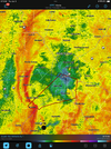
That might be the nastiest couplet I’ve ever seen tbh

Did y'all have much wind?Warm front moved through here east of athens within the past half hour and there was a 10 degree temp rise in 10 or 15 minutes. Still hasn't reached athens though with temps in the upper 40s. Unusual but not unheard of to see my local break through vs areas to the west.
A few gusts to 15 to 20 or so but nothing impressive yet. Washington is reporting winds gusting into the 30s. Athens has now broken through and is up to 57.Did y'all have much wind?
Sent from my SM-S911U using Tapatalk
Hopefully us up in the upstate is gonna dodge the biggest part of it other Than Tons of water. Looks like high winds and severe weather gonna go below upstateA few gusts to 15 to 20 or so but nothing impressive yet. Washington is reporting winds gusting into the 30s. Athens has now broken through and is up to 57.
Radar velocities are impressive aloft though with 90 to 95mph showing up around at 4500 to 5000 feet.
Yea its stout. Very Cold Rain ,hardly any wind recognizable at all. I had a feeling it would not erode like models kept saying. Well know in a few hours who winsI feel good about wedge holding on here. well I hope im right.
We should bump up to low to mid sixties - if not a little higher before the main front moves through early this afternoon.A few gusts to 15 to 20 or so but nothing impressive yet. Washington is reporting winds gusting into the 30s. Athens has now broken through and is up to 57.
Radar velocities are impressive aloft though with 90 to 95mph showing up around at 4500 to 5000 feet.

Just a regular Tuesday at
Yep. Nothing to see hear so far.Just a regular Tuesday at CAE
Still 44 here to your wsw. Wedge hanging on and the squall line is only an hour or so away. Meh.We should bump up to low to mid sixties - if not a little higher before the main front moves through early this afternoon.
View attachment 140811