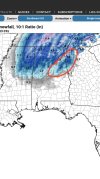
• Hello, please take a minute to check out our awesome content, contributed by the wonderful members of our community. We hope you'll add your own thoughts and opinions by making a free account!

Wintry Jan 2-4 2022 Winter Weather Event/Obs

I know Charlotte through Greensboro isn’t expected to see much, but the trend today for the 85 corridor from CLT-GSO has been pretty apparent, that’s where models most support the ULL moving over tomorrow, there’s a little bit of bust potential on the high side imo, I don’t see why some areas along that corridor don’t see a dusting tomorrow FD8DB420-63A2-439B-8A06-82C927E6382D.png 3799029B-210B-4E1C-936B-E54DDCE406FA.png380CDA8F-F613-41E2-BCD8-CB935B3E8C2C.png
 
Lots of blue starting to show on the back side of the precip . Cold air really diving SE now as H5 digs


Sent from my iPhone using Tapatalk
Should help also we are past peak heating of the day. The snow really should start expanding east in next hour or so.
 
I was surprised the RGEM didn’t tick south. Definitely gives me pause. I’m just hoping to see a nice burst of flakes in the air. Looks like you should get at least an inch on the ground? What are you thinking for your area?
Unless it shifts south another 50 miles, I'll see some light snow as the dying deform band rolls through. To close to the low and then that dry slot are problematic but we shall see. I think you out perform me with this one
 
Areas upstream are proving that rates CAN overcome very warm soil temps. But that doesn't mean the clown maps are right either. I'm not sold on any accumulations here but if we can manage to stay under that deformation band for 3 hours then maybe we can get a dusting.
 
Back
Top