• Hello, please take a minute to check out our awesome content, contributed by the wonderful members of our community. We hope you'll add your own thoughts and opinions by making a free account!

Wintry Jan 2-4 2022 Winter Weather Event/Obs

Monger, just checking in from the southern social circle burbs (just N of i20). Really hoping we can get this thing to hang together long enough to scratch out something before it pivots north!! I’m hoping for a 3/09 scenario?
Welp, we're not getting a 3/09 and any accumulations for our backyards is a stretch. That said, yeah, I'll be up late watching obs and radar lol. You know, hoping for that tail end of the deform band to thump is for an hour or so.
 
Welp, we're not getting a 3/09 and any accumulations for our backyards is a stretch. That said, yeah, I'll be up late watching obs and radar lol. You know, hoping for that tail end of the deform band to thump is for an hour or so.
I've just got a feeling that staying up late tonight could be a waste of time. But then again, with my luck i'd sleep all night and it would snow and then I'd wake up and it would already be melted.
 
Let these South Trends continue tonight and you watch NWS GSP will issue Advisories for the upstate north of 85. I'd bout bet on it cause that's way they handle things around here.

Sent from my SM-A526U using Tapatalk
 
HSV AFD mentioned thunder snow!

Models have trended up with snowfall amounts for this evening, so
that's the main change. Right now rain is spreading eastward across
Northern Alabama and Middle Tennessee. The feature we are watching
closely is the developing surface low over southwest Alabama, which
will track just southeast of our area. This puts us in the best area
for frontogenesis banding. Looking at model cross sections, all the
models show CSI as well, which will only help to enhance snowfall
rates over the area during the 7-11 PM timeframe. Can't rule out
thundersnow. The only limiting factor keeping us from very
significant snowfall amounts will be how long it takes for
temperatures to drop below freezing, and how long it takes for the
ground temperatures to drop below freezing. With significant snowfall
rates, don't think it will take too long after 00Z for northwest and
north-central Alabama and southern Middle Tennessee. Areas across
northeast Alabama probably won't drop below freezing before around 10
PM, which may keep snowfall amounts lower. For these reasons, I have
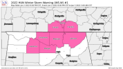
upgraded the Winter Weather Advisory for this evening to a Winter
Storm Warning for our north-central counties, including our counties
in Middle Tennessee. This is the area where the heaviest snowfall
rates will occur, and where we are expecting 2 to 3 inches of snow.
Elsewhere, amounts of 0.5 to 1.5 are more likely, but everyone should
at least see snow.
 
I've just got a feeling that staying up late tonight could be a waste of time. But then again, with my luck i'd sleep all night and it would snow and then I'd wake up and it would already be melted.
I retired just so I don't have to go in after looking for flurries in the street lights all night long.
 
WSW for the N GA mountains and they extended the advisory down a bit.
URGENT - WINTER WEATHER MESSAGE
National Weather Service Peachtree City GA
355 PM EST Sun Jan 2 2022

GAZ032-042-043-030500-
/O.EXA.KFFC.WW.Y.0001.220103T0500Z-220103T1400Z/
Cobb-Carroll-Douglas-
Including the cities of Marietta, Carrollton, and Douglasville
355 PM EST Sun Jan 2 2022

...WINTER WEATHER ADVISORY IN EFFECT FROM MIDNIGHT TONIGHT TO
9 AM EST MONDAY...

* WHAT...Wet snow expected with light snow accumulations from a
dusting up to one inch. Winds gusting as high as 35 mph.

* WHERE...Cobb, Carroll and Douglas Counties.

* WHEN...From midnight tonight to 9 AM EST Monday.

* IMPACTS...Plan on slippery road conditions. The hazardous
conditions could impact the morning commute.

PRECAUTIONARY/PREPAREDNESS ACTIONS...

Slow down and use caution while traveling.

&&
URGENT - WINTER WEATHER MESSAGE
National Weather Service Peachtree City GA
355 PM EST Sun Jan 2 2022

GAZ005>009-030500-
/O.UPG.KFFC.WW.Y.0001.220103T0500Z-220103T1400Z/
/O.NEW.KFFC.WS.W.0001.220103T0500Z-220103T1400Z/
Murray-Fannin-Gilmer-Union-Towns-
355 PM EST Sun Jan 2 2022

...WINTER STORM WARNING IN EFFECT FROM MIDNIGHT TONIGHT TO 9 AM
EST MONDAY...

* WHAT...Heavy wet snow expected with total snow accumulations of
one and a half to four inches forecast with locally higher
amounts possible, especially in areas 2000ft above sea level.
Winds gusting as high as 45 mph.

* WHERE...Murray, Fannin, Gilmer, Union and Towns Counties.

* WHEN...From midnight tonight to 9 AM EST Monday.

* IMPACTS...Travel could be very difficult. The hazardous
conditions could impact the morning commute.

PRECAUTIONARY/PREPAREDNESS ACTIONS...

If you must travel, keep an extra flashlight, food, and water in
your vehicle in case of an emergency.

&&

$$
 
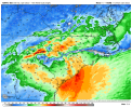
Is the moisture too fast for the change over?
fa770ae5552990509be35bac08300aa3.jpg


Sent from my motorola one 5G UW ace using Tapatalk
 
It's been a long while since I last posted on here. Been really busy with work. But I have been watching and am definitely intrigued by this system. I am not expecting much if anything in regards to accumulation but it will be nice to see the first flakes of the season falling. I also wanted to chime in on some of you who are expecting 6-inch+ totals. Not going to happen except for those folks in the mountains and MA. Definitely could see some 2-3 inch totals if you end up under the deformation band and are able to get some good rates. But we need to be more realistic when it comes to these clown maps. They hardly play out. Not trying to be a Debbie Downer. Edit-Unless a low did form in the Gulf that could change everything. Still rooting for everyone who wants snow to get it.
Welcome back!!!
 
Back
Top